


Assessing the Impact of Using Different Land Cover Classification in Regional Modeling Studies for the Manaus Area, Brazil
lượt xem 1
download
 Download
Vui lòng tải xuống để xem tài liệu đầy đủ
Download
Vui lòng tải xuống để xem tài liệu đầy đủ
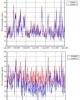
Land cover classification is one of the main components of the modern weather research and forecasting models, which can influence the meteorological variable, and in turn the concentration of air pollutants . In this study the impact of using two traditional land use classifications, the United States Geological Survey (USGS) and the Moderate-resolution Imaging Spectroradiometer (MODIS), were evaluated. The Weather Research and Forecasting model (WRF, version 3.2.1) was run for the period 18 - 22 August, 2014 (dry season) at a grid spacing of 3 km centered on the city of Manaus. The comparison between simulated and ground-based observed data revealed significant differences in the meteorological fields, for instance, the temperature. Compared to USGS, MODIS classification showed better skill in representing observed temperature for urban areas of Manaus, while the two files showed similar results for nearby areas. The analysis of the files suggests that the better quality of the simulations favorable to the MODIS file is straightly related to its better representation of urban class of land use, which is observed to be not adequately represented by USGS.
Bình luận(0) Đăng nhập để gửi bình luận!


Chịu trách nhiệm nội dung:
Nguyễn Công Hà - Giám đốc Công ty TNHH TÀI LIỆU TRỰC TUYẾN VI NA
LIÊN HỆ
Địa chỉ: P402, 54A Nơ Trang Long, Phường 14, Q.Bình Thạnh, TP.HCM
Hotline: 093 303 0098
Email: support@tailieu.vn
Giấy phép Mạng Xã Hội số: 670/GP-BTTTT cấp ngày 30/11/2015 Copyright © 2022-2032 TaiLieu.VN. All rights reserved.

