ISSN 1859-1531 - TP CHÍ KHOA HC VÀ CÔNG NGH - ĐẠI HỌC ĐÀ NẴNG, VOL. 23, NO. 1, 2025 1
ADVANCE PATH LOSS MODEL FOR LORAWAN COVERAGE ESTIMATION
HÌNH SUY HAO NÂNG CAO TRONG ƯỚC TÍNH VÙNG PHỦ MẠNG LORAWAN
Van Lic Tran*, Tran Dang Khoa Phan, Tran Thi Minh Hanh, Vu Van Thanh,
Thai Van Tien, Thai Vu Hien, Tran Anh Kiet
The University of Danang - University of Science and Technology, Vietnam
*Corresponding author: tvlic@dut.udn.vn
(Received: October 25, 2024; Revised: December 18, 2024; Accepted: December 26, 2024)
DOI: 10.31130/ud-jst.2025.456E
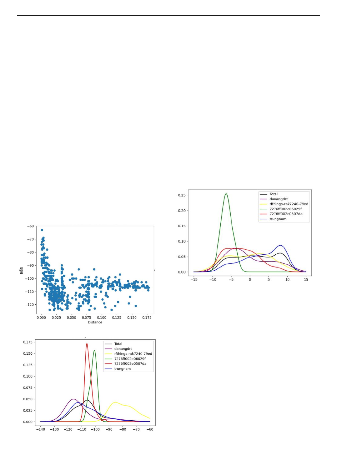
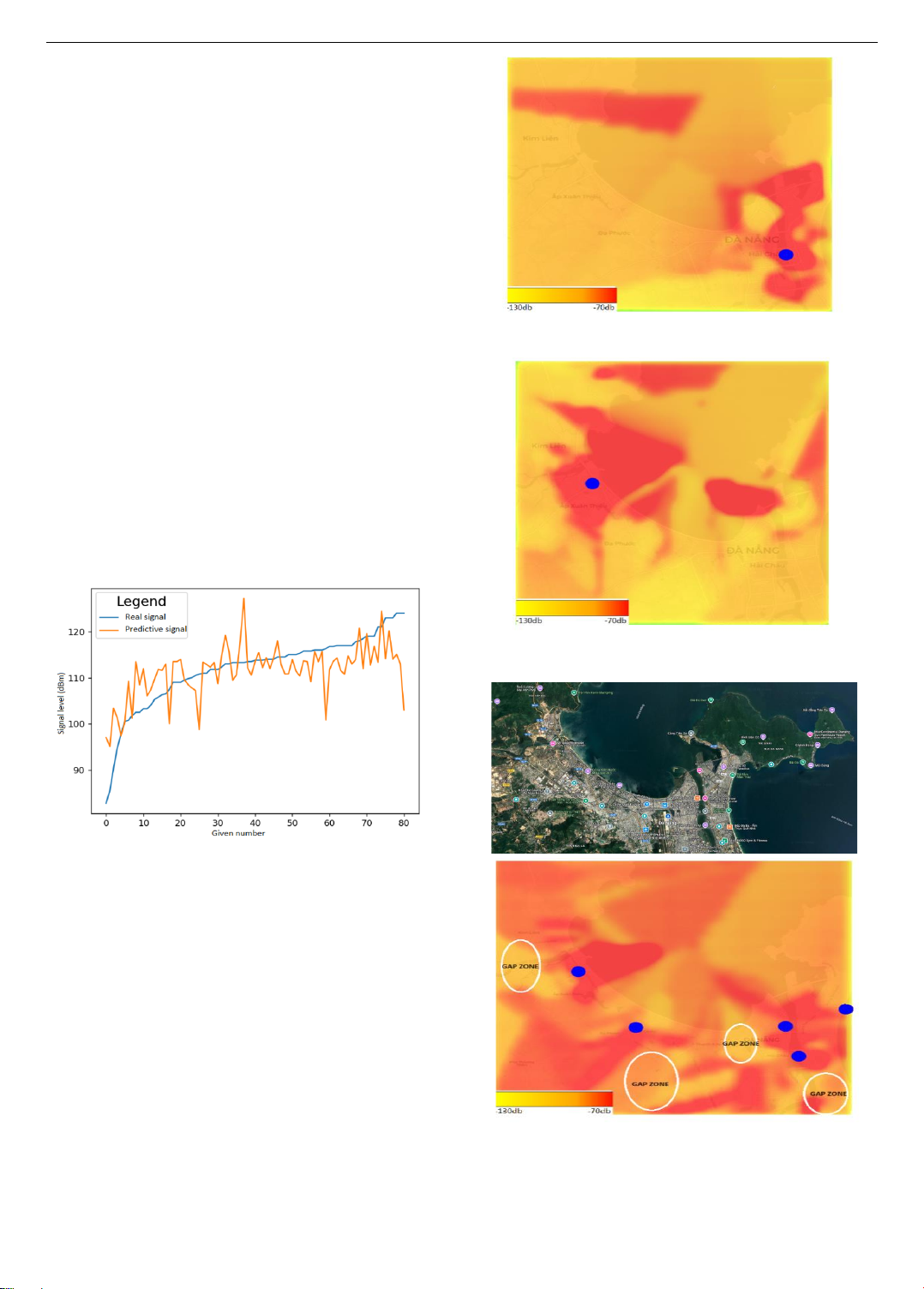
Abstract - This paper demonstrates that, using multiple data
points around each gateway allows for the creation of accurate
coverage heat maps by using a proposed LoRaWAN coverage
estimation algorithm. This method effectively identifies areas
with varying signal strength across Da Nang City, highlighting
where additional gateways are needed to improve network
reliability. Unlike previous studies, this research considers
environmental factors such as topography and urban structures,
enhancing prediction accuracy. This technique would be essential
for optimizing essential for optimizing LPWAN deployments and
ensuring efficient resource utilization. Future efforts will focus on
refining neural network models and integrating real-time data to
support scalable Smart City solutions and a more robust
connectivity infrastructure, with this work planned for future
research.
Tóm tắt - i báo này chứng minh rằng, việc sử dng nhiều điểm
dữ liệu xung quanh mỗi gateway cho phép tạo ra các bản đồ nhiệt
thể hiện vùng phủ ng chính xác nhờ thuật toán ước lượng phủ
sóng LoRaWAN được đề xuất. Phương pháp này được áp dụng
để xác định hiệu quả các khu vực cường độ tín hiệu khác nhau
tại thành phố Đà Nẵng, làm nổi bật những vị trí cần thêm gateway
để cải thiện độ tin cậy của mạng. Khác với các nghiên cứu trước
đây, nghiên cứu này xem xét các yếu tố như môi trường, địa hình
cấu trúc đô thị, giúp nâng cao độ chính xác của dự đoán vùng
phủ sóng. Kỹ thuật này rất quan trọng để tối ưu hóa việc triển khai
mạng LPWAN đảm bảo sử dụng tài nguyên hiệu quả. Các
nghiên cứu trong tương lai sẽ tập trung vào việc tinh chỉnh các
hình mạng -ron ch hợp dữ liệu thời gian thực để hỗ trợ
các giải pháp thành phố thông minh thể mở rộng sở hạ
tầng kết nối một cách nhanh chóng.
Key words - LPWAN; LoRaWAN; LoRa; path loss; coverage.
Từ khóa - LPWAN; LoRaWAN; LoRa; suy hao; vùng phủ.
1. Introduction
Low Power Wide Area Networks (LPWANs) have
recently garnered significant attention in Southeast Asia
due to their distinctive qualities, including low power
consumption, extensive coverage, and cost-effective
deployment. Among these, LoRaWAN stands out as a
globally standardized LPWAN technology, thanks to the
efforts of the LoRa Alliance. LoRaWAN is particularly
suitable for various IoT applications such as Smart
Tourism, Smart Agriculture, and Smart Cities [1]. Da
Nang, the fifth-largest city in Vietnam with over one
million inhabitants, serves as the commercial and
intellectual hub of Central Vietnam and is an ideal
candidate for implementing such technologies.
To deploy numerous LoRaWAN gateways around a
city, for example in a smart city application, accurately
estimating LoRaWAN network coverage is crucial for
effective planning and deployment, especially in urban
and large areas. This estimation allows for the strategic
placement of gateways to ensure optimal network
performance and coverage. By understanding the
coverage areas and potential signal gaps, planners can
determine the most efficient locations for gateways to
maximize connectivity and minimize interference. This
approach not only improves the reliability and quality of
the network but also ensures cost-effectiveness by
preventing the over-deployment of gateways.
Furthermore, accurate coverage estimation helps
anticipate and address environmental factors and
topographical challenges that may affect signal strength
and reliability. Ultimately, thorough coverage estimation
is essential for the successful implementation and
scalability of LoRaWAN networks, supporting various
IoT applications and enhancing the infrastructure of smart
cities [1].
A critical aspect of deploying the Smart City model
involves ensuring comprehensive network coverage across
the entire city. The study in [2] investigates LoRaWAN
network coverage through real-life measurements
conducted in Oulu, Finland. This research measured the
received signal strength from various locations within the
city, demonstrating a maximum communication range of
over 15 km on land and nearly 30 km on water. Another
study [3] employs a combination of real-world
measurements and high-fidelity simulations to show that
three gateways are sufficient to cover a dense urban area
within an approximately 15 km radius.
Research by [4] adopts a different approach by
evaluating multiple simulation tools, including Xirio,
Coverage Prediction and Analysis Software, Radio
Mobile, and Tower Coverage, to determine the most
suitable tool for LPWAN networks. Their findings indicate
that the Xirio tool offers the most accurate coverage
simulation for LoRaWAN technology. However, they
suggest that the final evaluation should integrate
simulation results with real-world measurements.
The study in [5] focuses on the coverage and capacity
analysis of LoRaWAN for typical massive IoT applications
in both urban and suburban areas, utilizing the simulation
tool Forsk Atoll 3.3.2. Similarly, the research in [6]
2 Van Lic Tran, Tran Dang Khoa Phan, Tran Thi Minh Hanh, Vu Van Thanh, Thai Van Tien, Thai Vu Hien, Tran Anh Kiet
deploys a LoRaWAN network and assesses signal quality
and coverage to identify blank spots on the map.
In another study, [7-8] introduces a cost-effective,
open-source technical solution and measurement
procedure for evaluating LoRaWAN network coverage in
dense urban environments. By assessing connection link
quality parameters, they developed a testing methodology
to determine the operational coverage of the deployed
network. The study by [9] implements an assessment of
radio network coverage, aiming to propose a new
methodology for selecting measurement points during
coverage and signal quality assessments. Finally, the
research in [10] provides recommendations for more
effective network deployment by optimizing the use of
LoRaWAN features, while the study in [11] analyzes
LoRaWAN network signal coverage and quality
parameters in real-time, using a case study of water quality
monitoring along the Cikumpa River in Depok City.
Most of the research has concentrated on LoRaWAN
network coverage using simulations and real-world
measurements. However, these studies do not fully account
for environmental factors influenced by topographical
conditions. Additionally, the estimation of LoRaWAN
network coverage based on real environmental conditions
has not been thoroughly examined.
In this research, an estimation algorithm is proposed
based on sparse coverage measurements to estimate
LPWAN coverage, specifically for LoRaWAN networks.
These new results are expected to assist in the network
planning process, which is a crucial step before deploying
a large number of gateways throughout a city.
2. LoRaWAN Deployment and Data Collection
The first step to obtaining a good estimation of network
coverage is to collect data. To achieve this, an end device
was used to record the RSSI (Received Signal Strength
Indicator), SNR (Signal-to-Noise Ratio), and its own
position. Then, a route through the city was created, which
is a specific route was planned and mapped through the city
to facilitate data collection and testing, aiming to gather the
most relevant data for prediction. To maximize the value
of the data, we tried to cover the entire city without
retracing the same roads. While we aimed to maximize the
spatial coverage by exploring diverse areas of the city, we
also recognize the importance of collecting multiple
measurements in the same locations under different
environmental conditions, including varying weather,
noise, and topographical influences, to better understand
their impact on network reliability.
In this experiment, five LoRaWAN gateways were
installed in the high building and top of mountain, and
Gateways were operated on AS923-2 band, which includes
Rak7240 and Kerlink iBTS with 3dBi Fiberglass Antenna.
These gateways were installed around Da Nang City with
location and altitude as shown in Table 1.
End device use in this experiment is a home-made UCA
board as shown in Figure 1. This PCB was developed to
ease connection between an Arduino Mini Pro, and an
RFM95 LoRa module, an AA battery. The antenna on this
PCB is a miniaturized, low-cost printed antenna, based on
a meandered F antenna (IFA) structure with a peak
directivity of 2.1 dBi and a peak gain of 0.9 dBi.
Table 1. List of gateways in Da Nang City
Gateway ID
Location
Altitude
Brand
Danangdrt
DRT Da Nang
building
45m
Rak7240
rfthings-rak7240-79ed
DUT building
35m
Rak7240
7276ff002e06029f
DSP building
90m
Kerlink iBTS
7276ff002e0507da
Son Tra
mountain
810m
Kerlink iBTS
trungnam
Trung Nam
building
80m
Rak7240
Figure 1. UCA board for data collection in Da Nang City
Figure 2. Data collection and terrain information
Data collection, as described in Figure 2, involved
traversing the city on a motorbike equipped with a
calibrated reference antenna, which was modified to be
suitable for the 920-923 MHz band. The UCA device is
held by the hand of the person sitting behind. This method
ensured accurate measurement of RSSI and Signal-to-
Noise Ratio (SNR) across various locations. The
motorcycle route was meticulously planned to cover
ISSN 1859-1531 - TP CHÍ KHOA HC VÀ CÔNG NGH - ĐẠI HỌC ĐÀ NNG, VOL. 23, NO. 1, 2025 3
diverse urban landscapes, including areas characterized by
tall buildings, open spaces, and potential signal
obstructions.
Our approach focused on capturing comprehensive data
to support accurate prediction models. By avoiding
duplicate routes and ensuring geographical diversity in our
data collection, we aimed to provide a holistic view of
network performance across Da Nang. This detailed
dataset serves as the foundation for our ongoing efforts to
optimize network deployment strategies and enhance
connectivity reliability in urban environments.
3. Proposed algorithm
RSSI ranging methods commonly used are based on
theoretical models such as the free space propagation path
loss model and the logarithmic normal shadowing model
[9]. However, the application environment of wireless
sensor signals is not in free space but in real-world settings
such as industrial sites or indoor buildings. In these
environments, it is necessary to consider factors such as
shading, obstacle absorption, and interference from
scattered reflections. The attenuation characteristics of
channels over long distances follow a lognormal
distribution, which is commonly modeled using the
logarithmic normal block model. The path loss model is as
follows [9]:
𝑃𝐿 (𝑑0)=𝑃𝐿(𝑑)+10𝑛𝑙𝑜𝑔(𝑑
𝑑0)+𝑋
(1)
In this formula, PL(d) represents the path loss of the
received signal at a distance d (meters). It is given as an
absolute power value in dBm. PL(𝑑0) denotes the path loss
of the received signal at the reference distance 𝑑0. The term
n is the path loss exponent specific to the environment,
indicating the rate at which path loss increases with the
distance d. 𝑋
is in dB and accounts for the shadowing
effect, with a standard deviation typically ranging from 4
to 10 and a mean value of 0. A larger value of implies
greater model uncertainty. The signal strength at the
receiving nodes is given by:
𝑅𝑆𝑆𝐼 =𝑃𝑡𝑃𝐿(𝑑) (2)
In this formula, 𝑃𝑡 represents the signal transmission
power, and 𝑃𝐿(𝑑) indicates the path loss at a distance d,
both are measured in dBm. Let A represents the signal
strength received from reference nodes at the distance 𝑑0.
The expression for A is as follows:
𝐴=𝑃𝑡𝑃𝐿(𝑑0) (3)
The path loss model, measured at the actual distance d
(meters), is as follows:
𝑃(𝑑)=𝑃(𝑑0)10𝑛𝑙𝑜𝑔(𝑑
𝑑0)𝑋
(4)
In this formula, PL(d) represents the received signal
strength when the actual distance measured is d (meters).
PL(𝑑0) represents the received signal strength at the
reference distance 𝑑0. The term 𝑋
denotes a random
variable following a normal distribution with mean 0 and
variance
2.
We set the reference distance 𝑑0 = 1 m, as derived from
formulas (3) and (5).
𝑅𝑆𝑆𝐼 =𝐴10𝑛𝑙𝑜𝑔(𝑑
𝑑0)𝑋
(5)
The distance can be calculated using the formula:
𝑑=10𝐴−𝑅𝑆𝑆𝐼
10𝑛 (6)
In our proposed algorithm, we work with each gateway
separately. For each gateway, we choose an arbitrary point.
We denote 𝑅𝑆𝑆𝐼𝑟𝑒𝑓 and 𝑑𝑟𝑒𝑓 as its values.
Let n be the environmental variable related to a point
and a gateway. Based on the formula (5), the core of the
algorithm is as follows:
𝑅𝑆𝑆𝐼 =𝑅𝑆𝑆𝐼𝑟𝑒𝑓 10𝑛𝑙𝑜𝑔( 𝑑
𝑑𝑟𝑒𝑓) (7)
It means that for any point, if we know its
environmental variable we can determine its RSSI. To
determine the environmental variable, we separate the
dataset on two groups:
The training dataset and the testing dataset. For each
training data we can calculate the environmental variable
because we know its position and its RSSI.
We use the following equation for the training dataset:
𝑛𝑡𝑟𝑎𝑖𝑛 =𝑅𝑆𝑆𝐼𝑟𝑒𝑓𝑅𝑆𝑆𝐼
10log( 𝑑
𝑑𝑟𝑒𝑓) (8)
Now that we know the environmental variable of the
training set, we can estimate the environment variables for
each data of the testing set with this equation:
𝑛𝑡𝑒𝑠𝑡 = 𝐶𝑜𝑒𝑓𝑓(𝑖)∗𝑛(𝑖)
𝑛
𝑖=0
𝐶𝑜𝑒𝑓𝑓(𝑖)
𝑛
𝑖=0 (9)
With n(i) is the environmental variable of the training
data number i. Coeff(i) is calculated as follow:
𝐶𝑜𝑒𝑓𝑓(𝑖)=𝑒(800−𝐷𝑖𝑠𝑡𝑎𝑛𝑐𝑒𝑚𝑖𝑛)2−(800−𝐷𝑖𝑠𝑡𝑎𝑛𝑐𝑒(𝑖))2 (10)
𝐷𝑖𝑠𝑡𝑎𝑛𝑐𝑒(𝑖) is the distance between training data
number i and the testing data. 𝐷𝑖𝑠𝑡𝑎𝑛𝑐𝑒𝑚𝑖𝑛 is the distance
between our testing data and its nearest training data.
This way of calculating 𝑛𝑡𝑒𝑠𝑡takes into account all the
𝑑𝑎𝑡𝑎𝑡𝑟𝑎𝑖𝑛 but will highly prioritize the nearest points,
where the environment should be similar.
Now that we have 𝑛𝑡𝑒𝑠𝑡, we can easily calculate
𝑅𝑆𝑆𝐼𝑡𝑒𝑠𝑡 with Equation (8). We can use the same method
to calculate the SNR and we get:
𝑆𝑖𝑔𝑛𝑎𝑙 = 𝑅𝑆𝑆𝐼 𝑖𝑓 𝑆𝑁𝑅 >0 (11)
𝑆𝑖𝑔𝑛𝑎𝑙 =𝑅𝑆𝑆𝐼+ 𝑆𝑁𝑅 𝑖𝑓 𝑆𝑁𝑅 <0 (12)
To get the total signal we take the maximum signal of
all gateways:
𝑆𝑖𝑔𝑛𝑎𝑙𝑡𝑜𝑡𝑎𝑙 =max (𝑠𝑖𝑔𝑛𝑎𝑙(𝑖)) (13)
The proposed algorithm was implemented using a
Python script, which is publicly available on GitHub at the
following the link: https://github.com/Lic-Tran-
Van/LoRaWANCoverageEstimation.git
The RSSI depends on the distance between the gateway
and the measurement point, as shown in Figure 3, and this
relationship is used in our prediction models. In this figure,
RSSI typically decreases as the distance between the
gateway and the end device increases. However, the
4 Van Lic Tran, Tran Dang Khoa Phan, Tran Thi Minh Hanh, Vu Van Thanh, Thai Van Tien, Thai Vu Hien, Tran Anh Kiet
relationship between RSSI and distance is not strictly
linear. This means that for each doubling of the distance,
the signal strength does not simply halve but decreases by
a certain factor, often modeled logarithmically. This
relationship is influenced by free-space path loss,
obstacles, environmental interference, and other factors
that cause signal attenuation [2].
In the context of a path loss model, "n" refers to the
path loss exponent, a key parameter that characterizes
how the signal strength decays as it propagates through
the environment. The value of n depends on the specific
environmental conditions and is influenced by factors
such as topography, urban structures, and other physical
obstacles. In free space (i.e., an unobstructed
environment), n is typically 2, as the signal strength
decreases proportionally to the square of the distance
from the transmitter (i.e., inverse square law). In urban or
indoor environments, n is usually greater than 2, ranging
from 2.7 to 4 or higher, because of the increased signal
attenuation caused by factors like buildings, walls, and
other obstructions. Additionally, n can be influenced by
weather conditions (e.g., rain or fog), which can further
attenuate the signal. For instance, in a rainy environment,
the path loss exponent can increase because the signal is
absorbed or scattered by raindrops. Similarly, noise from
other devices or environmental factors can add
uncertainty to the signal strength, impacting the accuracy
of path loss models.
Figure 3. Distance vs RSSI
Figure 4. Density plot of RSSI
The data stored in a CSV file via TTN Mapper was used
to generate the density plots of RSSI and SNR for each
gateway. Figure 4 shows the density plot of RSSI
(Received Signal Strength Indicator) values for each
gateway, as depicted in the attached image, illustrates the
distribution and concentration of RSSI measurements
across different gateways. The plot includes six different
gateways: 'Total', 'danangdrt', 'rfthings-rak7240-79ed',
'7276ff002e06029f', '7276ff002e0507da', and 'trungnam',
each represented by a unique color. The black line,
representing the 'Total' distribution, provides an overall
view of RSSI values across all gateways, showing a broad
peak around -110 dBm. 'danangdrt' (purple) and 'trungnam'
(blue) display similar distributions with peaks slightly left-
shifted relative to the 'Total' distribution, suggesting
somewhat stronger signals. The 'rfthings-rak7240-79ed'
(yellow) shows a much wider distribution with a notable
peak around -95 dBm, indicating varied signal strengths
with a tendency towards stronger RSSI values. The
gateways '7276ff002e06029f' (green) and
'7276ff002e0507da' (red) exhibit the highest peaks around
-100 dBm and -105 dBm, respectively, indicating very
strong and concentrated signal strengths.
Figure 5. Density plot of SNR
These variations highlight the differences in signal
reception quality among the gateways, with some capturing
stronger and more consistent signals compared to others.
The overall shape and spread of the density plots provide
insights into the reliability and performance of each
gateway in terms of RSSI.
The density plot of SNR (Signal-to-Noise Ratio)
values for each gateway, as shown in Figure 5 illustrates
the distribution and variability of SNR measurements
across different gateways. The 'Total' distribution,
represented by the black line, shows a broad spread of
SNR values with peaks around -5 dB and another smaller
peak around 7 dB, indicating a diverse range of signal
qualities. 'danangdrt' (purple) and 'trungnam' (blue) have
more dispersed distributions with peaks at different
points, suggesting varied signal-to-noise environments.
Specifically, 'trungnam' has a notable peak around 10 dB,
indicating better signal quality in some instances.
'Rftthings-rak7240-79ed' (yellow) displays a broad
distribution with multiple peaks, particularly around
-7 dB and slightly above 0 dB, reflecting fluctuations in
ISSN 1859-1531 - TP CHÍ KHOA HC VÀ CÔNG NGH - ĐẠI HỌC ĐÀ NNG, VOL. 23, NO. 1, 2025 5
signal quality. The gateways '7276ff002e06029f' (green)
and '7276ff002e0507da' (red) show more defined peaks,
with '7276ff002e06029f' having a prominent peak around
-7 dB, indicating consistent signal reception within a
narrower range. '7276ff002e0507da' displays multiple
peaks, with the highest around -6 dB, suggesting it
experiences various levels of signal quality. The
gateway's SNR (Signal-to-Noise Ratio) plays a critical
role in network performance. A high SNR (above 20 dB)
indicates strong, clear signals, resulting in reliable
communication, higher throughput, and low latency. A
moderate SNR (10-20 dB) suggests acceptable
performance but may experience occasional packet loss
or slower speeds due to some interference. A low SNR
(below 10 dB) indicates poor signal quality, leading to
higher error rates, reduced throughput, increased latency,
and connection instability, which negatively impacts
overall network performance.
The dataset comprises 400 data points divided into two
subsets: 80 % of the data serves as training data, and the
remaining 20 % is allocated for testing purposes. The
prediction model's accuracy, depicted in Figure 6 shows a
mean error of 4.5, indicating its effectiveness in estimating
signal strengths across Da Nang City. While this error is
evident, additional data acquisition is anticipated to notably
reduce it.
Figure 6. Results of the prediction on the testing data for
over 400 data points
To achieve a more uniform and detailed coverage map,
additional steps in data processing are crucial. This
includes employing advanced algorithms to refine signal
predictions based on factors such as topography, building
density, and environmental conditions. By integrating
more comprehensive data sets and leveraging sophisticated
analytical techniques, we aim to enhance the accuracy and
reliability of our coverage maps.
Figures 7 and 8 visually display the predicted data
points for the gateways danangdrt and trungnam,
respectively. The total coverage of all gateways was
estimated using Formula 13 and is depicted in Figure 9,
showing predictions across 10,000 points scattered
throughout the city. These maps provide a broad
overview of the predicted coverage, demonstrating that
our model accurately captures the general signal
distribution.
Figure 7. Da Nang coverage estimation by the Gateway danangdrt
Figure 8. Da Nang coverage estimation by
the Gateway trungnam
Figure 9. Da Nang coverage estimation with all gateways and
Identification of gap zones
Based on the coverage estimation with all gateways, it
is easy to identify gap zones, also known as coverage holes
or dead zones, where the LoRaWAN signal is weak or