
EURASIP Journal on Applied Signal Processing 2005:20, 3272–3292
c
2005 Gerhard Krieger et al.
Spaceborne Polarimetric SAR Interferometry:
Performance Analysis and Mission Concepts
Gerhard Krieger
Microwaves and Radar Institute, German Aerospace Centre (DLR) e.V., P.O. Box 1116, 82230 Wessling, Germany
Email: gerhard.krieger@dlr.de
Konstantinos Panagiotis Papathanassiou
Microwaves and Radar Institute, German Aerospace Centre (DLR) e.V., P.O. Box 1116, 82230 Wessling, Germany
Email: kostas.papathanassiou@dlr.de
Shane R. Cloude
School of Electrical and Electronic Engineering, The University of Adelaide, Adelaide, SA 5005, Australia
Email: scloude@eleceng.adelaide.edu.au
Received 30 July 2004; Revised 3 January 2005
We investigate multichannel imaging radar systems employing coherent combinations of polarimetry and interferometry (Pol-
InSAR). Such systems are well suited for the extraction of bio- and geophysical parameters by evaluating the combined scattering
from surfaces and volumes. This combination leads to several important differences between the design of Pol-InSAR sensors
and conventional single polarisation SAR interferometers. We first highlight these differences and then investigate the Pol-InSAR
performance of two proposed spaceborne SAR systems (ALOS/PalSAR and TerraSAR-L) operating in repeat-pass mode. For this,
we introduce the novel concept of a phase tube which enables (1) a quantitative assessment of the Pol-InSAR performance, (2) a
comparison between different sensor configurations, and (3) an optimization of the instrument settings for different Pol-InSAR
applications. The phase tube may hence serve as an interface between system engineers and application-oriented scientists. The
performance analysis reveals major limitations for even moderate levels of temporal decorrelation. Such deteriorations may be
avoided in single-pass sensor configurations and we demonstrate the potential benefits from the use of future bi- and multistatic
SAR interferometers.
Keywords and phrases: synthetic aperture radar, polarimetric SAR interferometry, bistatic radar, remote sensing, temporal decor-
relation, forest parameter inversion.
1. INTRODUCTION
One of the key challenges facing synthetic aperture radar
(SAR) remote sensing is to force evolution from high-
resolution qualitative imaging to accurate high-resolution
quantitative measurement. However, quantitative estimation
of relevant physical parameters from SAR data is in gen-
eral nontrivial due to the fact that the radar measurables are
not directly related to the desired parameters. Thus, the ex-
traction of bio- and geophysical parameters often requires
the inversion of scattering models that relate the radar ob-
servables to physical parameters of the scattering process.
Due to the complexity of electromagnetic (EM) scattering
This is an open access article distributed under the Creative Commons
Attribution License, which permits unrestricted use, distribution, and
reproduction in any medium, provided the original work is properly cited.
processes, even simple scattering models contain more pa-
rameters than the number of observables offered by a con-
ventional single-frequency, single-polarisation SAR acquisi-
tion. One approach to reduce the number of unknowns is
to utilise aprioriinformation about the occurring scattering
process and/or to introduce simplifying assumptions. The
price to be paid is the restricted applicability in terms of va-
lidity range or transferability of the resulting inversion algo-
rithms. A more promising approach is to extend the dimen-
sion of the observation vector by means of multiparameter
SAR data acquisitions.
One very promising way to extend the observation space
is the combination of interferometric and polarimetric ob-
servations. SAR interferometry is today an established tech-
nique for estimation of the height location of scatterers
through the phase difference in images acquired from spa-
tially separated apertures at either end of a baseline [1,2,3].

Spaceborne Polarimetric SAR Interferometry 3273
The sensitivity of the interferometric phase and coherence
to spatial variability of vegetation height and density make
the estimation of vegetation parameters from interferomet-
ric measurements at lower frequencies (C-, L-, or P-band) a
challenge [4,5,6,7]. On the other hand, scattering polarime-
try is sensitive to the shape, orientation, and dielectric prop-
erties of scatterers. This allows the identification and separa-
tion of scattering mechanisms of natural media by employing
differences in the polarisation signature for purposes of clas-
sification and parameter estimation [8,9]. In polarimetric
SAR interferometry (Pol-InSAR), both techniques are coher-
ently combined to provide sensitivity to the vertical distribu-
tion of different scattering mechanisms [10,11,12]. Hence,
it becomes possible to investigate the 3D structure of vol-
ume scatterers such as vegetation and ice, promising a break-
through in radar remote sensing problems.
Regarding the range of natural volume scatterers, forest
scatterers are the ones that obtained most of the scientific
attention over the last years leading to impressive results.
Indeed, accurate estimation of forest height from model-
based inversion of Pol-InSAR data has been demonstrated
and validated over a large range of temperate and boreal re-
gional test sites using airborne sensors [12,13,14,15]. The
fact that forest height is the most important single forest
parameter for ecological as well as for commercial applica-
tions [16,17,18,19] and that it allows an unbiased forest
biomass estimation [20,21] makes its estimation in terms of
Pol-InSAR a key SAR technique. However, in order to evolve
from local/regional to large-scale/global demonstrations and
products—not only in forest applications—the implemen-
tation of Pol-InSAR technology in a spaceborne scenario is
essential.
For Pol-InSAR applications, the performance criteria
that apply to space-borne missions/sensors are different from
the ones used in conventional and differential InSAR topo-
graphic mapping applications. For conventional InSAR DEM
generation, the system performance is measured against the
final height error—referred to a surface—that is composed of
(a) the standard deviation dictated by the overall system co-
herence for a given imaging geometry and scatterer structure
and (b) the height error introduced by the imaging geometry
estimation. Pol-InSAR applications now deal with parameter
estimation of natural volume scatterers based on the polari-
metric diversity of InSAR observations (i.e., coherence and
phase). Accordingly, one key criterion for the performance
of a Pol-InSAR configuration is how strong the InSAR co-
herence and phase vary with polarisation, and how accurate
this variation can be estimated. The actual level of the In-
SAR coherence affects the overall performance through the
possible estimation accuracy of the observables rather than
in a direct way. The variation of InSAR coherence and phase
with polarisation and the uncertainty in their estimation—
as a consequence of nonunity coherence—depend on system
parameters as well as on structural properties of the volume
scatterer under consideration.
In Section 2, the individual decorrelation contributions
induced by the system, the imaging geometry, and the
scattering process are discussed with respect to Pol-InSAR
volume parameter inversion. The main system parameters
that impact the overall interferometric coherence are re-
viewed. The random volume over ground (RVoG) scattering
model is used to describe the effect of the scatterer on the
InSAR observables as a function of system parameters. Even
if the discussion is held in a more general frame, the main
scenario considered in this paper is forest scattering at L-
band. Section 3 investigates the achievable performance of
a repeat-pass Pol-InSAR mission scenario. For this, two ac-
tual L-band missions will be considered as illustrative ex-
amples (ALOS/PalSAR and TerraSAR-L). It is shown that
the achievable performance will be strongly affected even
by moderate levels of temporal decorrelation. Hence, sev-
eral single-pass Pol-InSAR mission scenarios will be inves-
tigated in Section 4. Such systems use multiple satellites fly-
ing in close formation and allow for the acquisition of in-
terferometric and polarimetric data during one satellite pass,
thereby minimizing the distortions from temporal decorre-
lation [22,23,24]. The performance analysis for a poten-
tial TerraSAR-L cartwheel configuration illustrates the ex-
cellent Pol-InSAR parameter inversion accuracy to be ex-
pected from such a polarimetric single-pass interferometer.
Section 5 concludes the paper with a general discussion of
the potentials and limitations of the investigated Pol-InSAR
mission scenarios for the acquisition of polarimetric and in-
terferometric data on a global scale.
2. PERFORMANCE ANALYSIS
In this section, we discuss the major system and scatterer pa-
rameters which affect the accuracy of the Pol-InSAR volume
parameter inversion. A key quantity in estimating the perfor-
mance of any interferometric SAR system is coherence. As-
suming additive and statistically independent error sources,
the total coherence γtot including both the interferometric
correlation coefficient and the interferometric phase is given
by the product
γtot =γSNR ·γQuant ·γAmb ·γCoreg ·γGeo ·γAz ·γVol ·γTe m p ,(1)
where the right-hand side describes the individual error con-
tributions:
(i) γSNR: finite SNR due to thermal noise (scalar contribu-
tion),
(ii) γQuant: quantization errors (scalar contribution),
(iii) γAmb: range and azimuth ambiguities (scalar contribu-
tion),
(iv) γCoreg: coregistration and processing errors (scalar con-
tribution),
(v) γGeo: baseline decorrelation (scalar contribution),
(vi) γAz: decorrelation due to Doppler shift (scalar contri-
bution),
(vii) γVo l : volume decorrelation (complex contribution),
(viii) γTe m p : temporal decorrelation (complex contribution).
The first six terms are decorrelation contributions due to sys-
tem, processing, and acquisition geometry effects. They are

3274 EURASIP Journal on Applied Signal Processing
scalar quantities as they contribute only to the overall inter-
ferometric correlation coefficient.Thelasttwotermsarein-
troduced by the scatterer and reflect its structural and tem-
poral stability properties. They are complex contributions as
they also affect the measured interferometric phase. In the
following, the individual contributions will be discussed.
2.1. Volume decorrelation
The penetration into and through natural volume scat-
terers (such as vegetation, sand, and ice) at longer wave-
lengths makes volume decorrelation an important decorre-
lation contribution. At the same time, it is γVol that contains
the physical information about the vertical structure of the
volume scatterer as it is directly related—after range spectral
filtering—to the Fourier transform of the vertical distribu-
tion of the effective scatterers ρV(z)as[
4,7,13]
γVol =ρV(z′)expiκzz′dz′
ρV(z′)dz′,(2)
where κzis the effective vertical interferometric wavenumber
after range spectral filtering, which depends on the imaging
geometry and the radar wavelength
κz=κ∆θ
sin θinc(3)
with κ=4π/λ for a repeat-pass mission scenario (κ=2π/λ
for a single-pass mission scenario), the reference incidence
angle θinc, and the incidence angle difference ∆θbetween
the two interferometric images induced by the baseline. To
perform a quantitative evaluation of γVol , a scattering model
describing the vertical distribution of the effective scatterers
ρV(z) has to be introduced. An appropriate model for this is
the random volume over ground (RVoG) model [7,12,13]
which has been successfully exploited over the last years for
quantitative forest parameter estimation from multiparame-
ter InSAR data. The RVoG is a two-layer model (vegetation
layer and ground) that expresses the interferometric coher-
ence and phase as a function of four scatterer parameters: (1)
the volume thickness that corresponds to vegetation height,
(2) the volume extinction coefficient that describes the atten-
uation through the vegetation layer, (3) the effective ground-
to-volume amplitude ratio, defined as the ratio of the ground
scattering amplitude attenuated by the volume to the vol-
ume scattering amplitude, and (4) the phase related to the
underlying topography. According to the RVoG model, the
complex interferometric coherence γVol (
w) after range spec-
tral filtering is given by [12,13]
γVol (
w)=exp iφ0γV+m(
w)
1+m(
w),(4)
where
wis a unitary vector that defines the polarisation of the
interferogram and indicates the polarimetric dependency. γV
denotes the coherence for the volume alone, which depends
on the extinction coefficient σfor the random volume and
the volume thickness hVas
γV=I
I0
,
I=hV
0exp iκzz′exp 2σz′
cos θ0dz′,
I0=hV
0exp 2σz′
cos θ0dz′,
(5)
where φ0is the phase related to the ground topography, and
mis the effective ground-to-volume scattering ratio account-
ing for the attenuation through the volume
m(
w)=mG(
w)
mV(
w)I0
,(6)
where mGis the scattered return from the ground seen
through the vegetation (including direct surface and dihe-
dral scattering contributions) and mVis the direct volume
scattering return [12].
The extinction coefficient σcorresponds to a mean ex-
tinction value for the vegetation layer expressing scattering
and absorption losses. It is a function of the density of scat-
terers in the volume and their dielectric constant, and is as-
sumed to be independent of polarisation [12,13]. Changes of
polarisation influence the interferometric coherence through
the variation of the ground-to-volume amplitude ratio m
that is the only model parameter that depends on the polari-
sation of the incident wave
w. In the limit of zero extinction
coefficient, γVbecomes the well-known sin(x)/x decorrela-
tion function:
γV=exp iφ0+iκzhV
2sin κzhV/2
κzhV/2.(7)
According to (4), the effective phase center is located above
the ground at a height that depends on the ground-to-
volume amplitude ratio mas well as the attenuation length
of the vegetation layer.
Figure 1 shows the variation of the interferometric phase
(Figure 1a) and the interferometric coherence (Figure 1b)as
predicted by the RVoG model for a volume thickness hV=
20 m, with an extinction coefficient σ=0.3 dB/m, and an
interferometric configuration with a vertical wavenumber of
κz=0.15 rad/m (corresponding to a 2πheight of 40 m) as
a function of the ground-to-volume amplitude ratio mthat
varies from −20 dB to 20 dB. For illustration, we have as-
sumed 16 independent looks in deriving the interferometric
phase errors. Looking at the interferometric phase variation
(bluecontinuousline),onecanseethatthephasecenterfor
practically zero ground contribution (at m=−20 dB) is lo-
cated two thirds of the total volume height (indicated by the
red dashed line) above ground (indicated by the blue dashed
line) and moves monotonically with increasing ground con-
tribution towards ground level that is reached at mhigher
than 10 dB.

Spaceborne Polarimetric SAR Interferometry 3275
−20 −10 0 10 20
0
1
2
3
4
hVκz
∆m
Ground-to-volume ratio (dB)
Interferometric phase (rad)
(a)
−20 −10 0 10 20
0
0.2
0.4
0.6
0.8
1
|˜
γV|
Ground-to-volume ratio (dB)
Interferometric coherence
(b)
Figure 1: (a) Interferometric phase and (b) interferometric coherence as a function of the ground-to-volume amplitude ratio m(hV=20 m,
σ=0.3 dB/m, κz=0.15 rad/m, 16 looks).
In contrast to the phase behaviour, the interferomet-
ric coherence variation, shown in Figure 1b,isnotmono-
tonic with m: starting from almost no ground contribution
(m=−20 dB) with a coherence corresponding to the vol-
ume layer alone (in this particular case at 0.7), the coher-
ence decreases with increasing ground contribution: due to
the scattering contribution at the bottom of the volume, the
overall (volume + ground) scattering center moves towards
ground. This way, the effective volume seen by the interfer-
ometer increases, which in turn increases volume decorre-
lation. Further amplification of the ground contribution—
beyond a certain level—leads now to rising coherence values
as the ground becomes more and more the dominant scat-
tering contribution, and finally, for very strong ground con-
tributions, the coherence converges to one.
The separation of the phase centers at the different polar-
isations (i.e., for different values of m) depends on both the
variation of the phase center with mand the standard devi-
ation of the phase estimate associated to the corresponding
interferometric coherence value. In the phase variation plot
(Figure 1a), the red tube indicates the phase ±1 standard de-
viation region defined by the corresponding coherence vari-
ation (Figure 1b ) for 16 looks [25,26,27]: the standard de-
viation reaches its maximum in the lower coherence region
(−7dB <m<2 dB) and its minimum in the high coherence
area (m>10 dB).
The ability of a system configuration to separate the
phase centers at the different polarisations (for a given scat-
terer configuration) can be expressed as the amount of the
ground-to-volume ratio variation ∆mrequired to cause a
phase variation larger than the phase standard deviation at
a given reference point on the m-axis. It becomes obvious
that thinner and/or steeper tubes correspond to a better
Pol-InSAR performance, as a vertical phase center separa-
tion larger than the standard deviation can be achieved by
smaller ∆m. Note that in Figure 1 the tube is only due to the
effect of volume decorrelation (assuming an ideal InSAR sys-
tem). Any of the system-induced decorrelation contributions
of (1) will further reduce the coherence values leading to a
thicker tube. In this sense, system configurations that provide
overall thin and steep tubes—and keep the system-induced
tube contribution small compared to the volume decorrela-
tion contribution—are better suited for Pol-InSAR applica-
tionsthanbroadtubeswithsmallphasevariation.
On the other hand, scattering scenarios in which the vari-
ation of polarisation leads to a wide range of mvalues located
in the sensitive area of the phase tube allow optimal parame-
ter inversion. The range of mvalues depends on the strength
of the underlying scattering process and its attenuation by
the vegetation layer.
2.1.1. Imaging geometry parameters
The choice of the spatial baseline has always to be opti-
mised with respect to the individual applications. In con-
ventional DEM generation, for example, large baselines that
provide high phase to height sensitivity are desired, lim-
ited only by the available system bandwidth (range spectral
decorrelation) and the terrain conditions. The baseline re-
quirements are different in the case of Pol-InSAR applica-
tions over volume scatterers. Especially at longer wavelengths
volume decorrelation dictates the maximum useful baseline
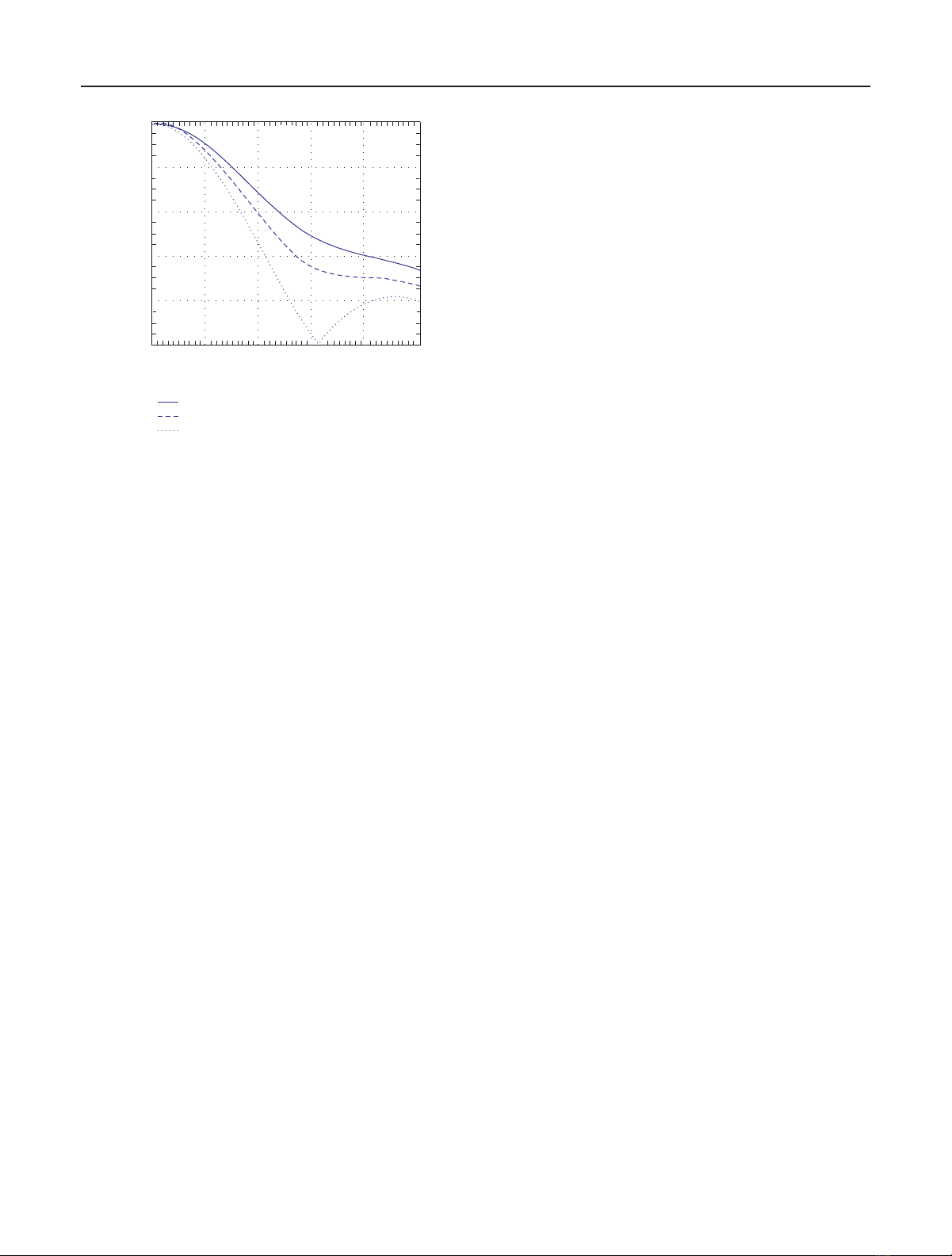
length. Figure 2 shows the volume decorrelation according to
(5)expectedforavolumeheightof20masafunctionofthe
vertical wavenumber κzfor different volume extinction val-
ues. The coherence drops below the critical mark of 0.3 for a
κzvalue on the order of 0.2–0.3 rad/m. This corresponds to
about 40% of the critical baseline of ALOS-PalSAR and about
7% of the critical baseline of TerraSAR-L (assuming 80 MHz
bandwidth).
However, note that even if a larger baseline increases vol-
ume decorrelation, it still provides a higher phase to height
sensitivity that may compensate (up to a certain baseline) the
3276 EURASIP Journal on Applied Signal Processing
0
0.2
0.4
0.6
0.8
1
00.10.20.30.40.5
σ=0.6dB/m
σ=0.3dB/m
σ=0dB/m
Ve r ti ca l w a ve n um b e r
Interferometric coherence
Figure 2: Volume decorrelation.
loss in coherence. In other words, the error in height caused
by a given phase standard deviation at a small baseline may
be finally larger than the error for a larger baseline, even if
for the larger baseline the phase standard deviation is larger
due to the higher volume decorrelation. The realisation of
small baselines, in order to keep volume decorrelation low
and to allow high coherence levels, can be a promising con-
cept as long as the system-induced decorrelation effects are
kept small. If this is not the case, the system-induced decorre-
lation becomes large relative to the underlying volume decor-
relation and the small baseline concept fails due to the ad-
verse phase-to-height uncertainty transformation. The vari-
ation of the Pol-InSAR performance with different baseline
lengths will be demonstrated in Sections 3and 4.Asafirst
rule of thumb, the baselines should be chosen such that the
magnitude of the system-induced height errors is compara-
ble to the errors from volume decorrelation.
Another geometric parameter that affects the perfor-
mance of a Pol-InSAR configuration is the incident angle. In
general, an increase of the incident angle leads to a reduc-
tion of the backscattered signal and thus to an increase of the
SNR decorrelation contribution. According to [28], the vari-
ation of backscattering (at X-, C-, and L-band) from forest
is in average 3–5 dB for incident angles in the range between
20 and 50 degrees. This affects—as already discussed—the
estimation performance due to the additional decorrelation
contribution, and—if not accounted for—introduces a bias
in the parameter estimates.
Even more important is the dependency of the ground
attenuation on the incident angle. With increasing incident
angle, the travelled distance of the transmitted and scattered
waves through the vegetation layer increases, thereby increas-
ing the attenuation of the wave and making the effective
ground contribution weaker. Figure 3a shows the wave at-
tenuation as a function of incidence angle assuming a vol-
ume height of hV=20 m for three different extinction
coefficients: σ=0.3, 0.6, and 0.9 dB/m. It is characteristic
that a variation of the incident angle from 20 to 50 degrees
has the same effect as an increase of vegetation height from 20
to 30 meters. Assuming that in first order the (polarimetric)
dynamic range of the ground scattering is independent of the
incident angle, the range of the effective ground-to-volume
ratios remains constant with increasing incident angle but is
shifted towards lower mvalues as indicated in Figure 3b.At
35 degrees, the effective ground-to-volume ratios are about
3 dB lower than at 25-degree incidence—for a mean extinc-
tion of 0.6 dB/m. In this sense, steeper incident angles are
favourable as they lead to higher mvalues. A variation of the
(polarimetric) dynamic range of ground scattering with in-
cident angle will additionally affect the performance.
2.1.2. Reference scenario
The discussion above makes clear that the performance of a
Pol-InSAR system depends strongly on the parameters of the
scattering scenario. Data derived from simulations of a Scots
pine forest stand [29] will be used to define an appropriate
reference for the performance analysis (cf. Tabl e 1 ). Note that
the parameters in [29] have been derived for an incident an-
gle of 45◦. In order to be compatible with the incident an-
gle range of the radar sensors considered in Sections 3and
4(the maximum incident angle for TerraSAR-L operating
in full polarimetric mode is 36◦), the parameter set had to
be adapted appropriately. The major difference relates to the
lower incident angle that will increase the ground-to-volume
amplitude ratios where a shift of the mvalues by +5 dB has
been assumed. This increase seems to be justified by the
lower total extinction in the volume, the stronger ground
contributions for steeper incident angles, and the fact that
the vegetation model in [29] did not account for the scat-
tering from understory. Furthermore, equal scattering coef-
ficients of −11 dB m2/m2will be assumed for all polarisa-
tions. By this, we avoid different SNR values that would lead
to different performance predictions for the different polar-
isations. Note that the number of independent radar pulses
recorded in the cross-polar channel is twice the number of
pulses recorded in each copolar channel. This increase of in-
dependent samples corresponds to an improvement of the
SNR by 3 dB which compensates in part the lower scattering
in cross-polarisation. The chosen scattering coefficient corre-
sponds hence to an effective cross-polar scattering coefficient
of −14 dB m2/m2which we regard as a lower bound for the
strength of the scattered signal. Hence, the parameters pro-
vided in Table 1 reflect rather conventional assumptions for
the investigated Scots pine forest scenario.
2.2. Temporal decorrelation
Temporal decorrelation is probably the most critical factor
for a successful implementation of Pol-InSAR parameter in-
version techniques in terms of conventional repeat-pass In-
SAR scenarios. Similar to any other system-induced decorre-
lation contribution, temporal decorrelation reduces the per-
formance of a Pol-InSAR configuration by biasing the vol-
ume decorrelation contribution that is used for parameter


%20--%3e%3cdefs%3e%3cstyle%3e%20.st0%20{%20fill:%20%23fff;%20}%20.st1%20{%20fill:%20%237800fa;%20}%20%3c/style%3e%3c/defs%3e%3cpath%20class='st1'%20d='M117.78,12.18H43.11c2.9,3.47,4.65,7.94,4.65,12.82,0,5.6-2.3,10.66-6.01,14.29h76.02l7.22-13.56-7.22-13.56Z'/%3e%3cg%3e%3cpath%20class='st0'%20d='M53.58,26.17h-.59v-1.46h.59v-4.96h2.83c1.78,0,2.67.94,2.67,2.82v5.76c0,1.87-.89,2.81-2.67,2.81h-2.83v-4.96ZM55.36,21.37v3.34h1.1v1.46h-1.1v3.34h1.01c.61,0,.91-.37.91-1.1v-5.93c0-.74-.3-1.1-.91-1.1h-1.01Z'/%3e%3cpath%20class='st0'%20d='M65.99,31.14h-1.8l-.31-2.07h-2.19l-.31,2.07h-1.64l1.82-11.39h2.62l1.82,11.39ZM65.28,18.04c-.25.46-.51.77-.75.94-.21.15-.47.22-.79.22-.26,0-.57-.07-.92-.22l-.38-.15c-.14-.05-.26-.07-.37-.07-.3,0-.53.18-.71.54l-.91-.68c.25-.46.51-.77.75-.94.21-.14.48-.21.79-.21.26,0,.57.07.92.21l.38.15c.14.05.26.07.37.07.3,0,.53-.18.71-.54l.91.68ZM61.91,27.52h1.73l-.87-5.76-.87,5.76Z'/%3e%3cpath%20class='st0'%20d='M74.53,26.89v1.52c0,1.91-.89,2.86-2.67,2.86s-2.67-.95-2.67-2.86v-5.93c0-1.91.89-2.86,2.67-2.86s2.67.95,2.67,2.86v1.11h-1.69v-1.22c0-.75-.31-1.12-.93-1.12s-.93.37-.93,1.12v6.15c0,.74.31,1.11.93,1.11s.93-.37.93-1.11v-1.63h1.69Z'/%3e%3cpath%20class='st0'%20d='M81.4,31.14h-1.8l-.31-2.07h-2.19l-.31,2.07h-1.64l1.82-11.39h2.62l1.82,11.39ZM75.9,19.2l1.52-1.91h1.71l1.51,1.91h-1.61l-.76-.95-.75.95h-1.61ZM77.32,27.52h1.73l-.87-5.76-.87,5.76ZM83.1,15.99l-1.76,1.91h-1.26l1.17-1.91h1.86Z'/%3e%3cpath%20class='st0'%20d='M84.86,19.75c1.78,0,2.67.94,2.67,2.82v1.48c0,1.87-.89,2.81-2.67,2.81h-.85v4.28h-1.79v-11.39h2.64ZM84.01,21.37v3.86h.85c.58,0,.87-.36.87-1.08v-1.71c0-.71-.29-1.07-.87-1.07h-.85Z'/%3e%3cpath%20class='st0'%20d='M93.51,19.75c1.78,0,2.67.94,2.67,2.82v1.48c0,1.87-.89,2.81-2.67,2.81h-.85v4.28h-1.79v-11.39h2.64ZM92.66,21.37v3.86h.85c.58,0,.87-.36.87-1.08v-1.71c0-.71-.29-1.07-.87-1.07h-.85Z'/%3e%3cpath%20class='st0'%20d='M98.8,31.14h-1.79v-11.39h1.79v4.88h2.03v-4.88h1.83v11.39h-1.83v-4.88h-2.03v4.88Z'/%3e%3cpath%20class='st0'%20d='M105.36,24.55h2.46v1.62h-2.46v3.34h3.09v1.63h-4.88v-11.39h4.88v1.63h-3.09v3.18ZM108.17,17.29l-1.76,1.91h-1.26l1.17-1.91h1.86Z'/%3e%3cpath%20class='st0'%20d='M112.2,19.75c1.78,0,2.67.94,2.67,2.82v1.48c0,1.87-.89,2.81-2.67,2.81h-.85v4.28h-1.79v-11.39h2.64ZM111.35,21.37v3.86h.85c.58,0,.87-.36.87-1.08v-1.71c0-.71-.29-1.07-.87-1.07h-.85Z'/%3e%3c/g%3e%3ccircle%20class='st1'%20cx='25'%20cy='25'%20r='20'/%3e%3cpath%20class='st0'%20d='M32.78,19.27c2.92,0,4.43,2.55,5.28,5.33l.71,2.17c.14.38-.33.75-.71.75h-5.61c.19-.33.24-.71.09-1.08l-.75-2.45c-.43-1.32-.99-2.64-1.79-3.77.75-.57,1.65-.94,2.78-.94h0ZM25,18.38c3.25,0,4.9,2.78,5.89,5.89l.76,2.45c.14.42-.33.8-.8.8h-11.69c-.42,0-.94-.38-.8-.8l.75-2.45c.99-3.11,2.64-5.89,5.89-5.89h0ZM25,11.35c1.74,0,3.11,1.37,3.11,3.11s-1.37,3.11-3.11,3.11-3.11-1.41-3.11-3.11,1.41-3.11,3.11-3.11h0ZM17.27,19.27c1.08,0,1.98.38,2.73.94-.8,1.13-1.37,2.45-1.74,3.77l-.8,2.45c-.14.38-.05.75.09,1.08h-5.56c-.42,0-.9-.38-.75-.75l.71-2.17c.9-2.78,2.41-5.33,5.33-5.33h0ZM17.27,12.91c1.51,0,2.78,1.27,2.78,2.83s-1.27,2.83-2.78,2.83-2.83-1.27-2.83-2.83,1.27-2.83,2.83-2.83h0ZM32.78,12.91c1.56,0,2.78,1.27,2.78,2.83s-1.23,2.83-2.78,2.83-2.83-1.27-2.83-2.83,1.27-2.83,2.83-2.83h0ZM27.07,28.56v.09c0,.57-.24,1.08-.61,1.46h0v.05c-.38.33-.9.57-1.46.57s-1.08-.24-1.46-.61h0c-.38-.38-.61-.9-.61-1.46v-.09h1.41v.09c0,.19.05.38.19.47v.05c.09.09.28.19.47.19s.38-.09.47-.19v-.05c.14-.09.24-.28.24-.47t-.05-.09h1.41ZM30.99,28.56v.09c0,1.65-.66,3.16-1.74,4.24-1.08,1.08-2.59,1.79-4.24,1.79s-3.16-.71-4.24-1.79l-.05-.05c-1.04-1.08-1.7-2.55-1.7-4.2v-.09h1.41v.09c0,1.27.47,2.4,1.27,3.25h.05c.85.85,1.98,1.37,3.25,1.37s2.4-.52,3.25-1.37c.85-.8,1.37-1.98,1.37-3.25v-.09h1.37ZM34.99,28.56v.09c0,2.78-1.13,5.28-2.92,7.07-1.79,1.79-4.29,2.92-7.07,2.92s-5.23-1.13-7.07-2.92c-1.79-1.79-2.92-4.29-2.92-7.07v-.09h1.41v.09c0,2.4.94,4.53,2.5,6.08,1.56,1.56,3.72,2.5,6.08,2.5s4.52-.94,6.08-2.5c1.56-1.56,2.5-3.68,2.5-6.08v-.09h1.41Z'/%3e%3c/svg%3e)