TNU Journal of Science and Technology
229(06): 32 - 40
http://jst.tnu.edu.vn 32 Email: jst@tnu.edu.vn
DISTRIBUTION AND GEOCHEMISTRY OF LEAD IN TIDAL CREEK
SEDIMENT IMPACTED BY ANTHROPOGENIC ACTIVITIES
Le Quang Huy1, 2, To Thi Hong Chuyen1, Nguyen Van Dong1, Le Thi Huynh Mai1, Nguyen Thanh Nho2*
1University of Science - Vietnam National University, Ho Chi Minh City
2Institute of Applied Technology and Sustainable Development - Nguyen Tat Thanh University
ARTICLE INFO
ABSTRACT
Received:
28/11/2023
Mangrove-dominated estuaries could play an important role in
mitigating pollutants from the land to the sea. However, changes in the
physicochemical characteristics of water and sediment could affect the
spatiotemporal distribution of pollutants, including heavy metals which
may induce ecological risks to organisms during tidal cycles and
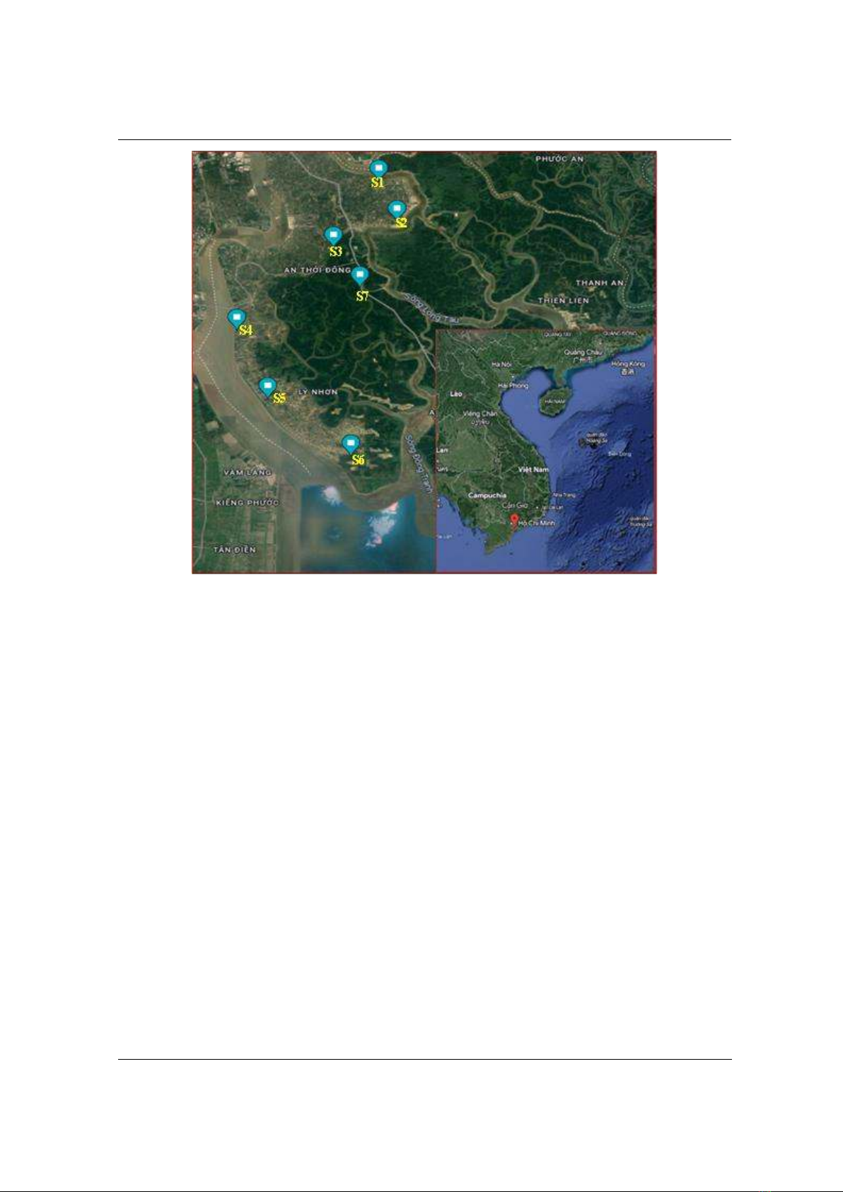
seasons. In the present study, we aimed to evaluate the lead (Pb)
partitioning and its ecological risks in tidal creek sediments within the
Can Gio mangrove estuary by using a method of sequential extraction.
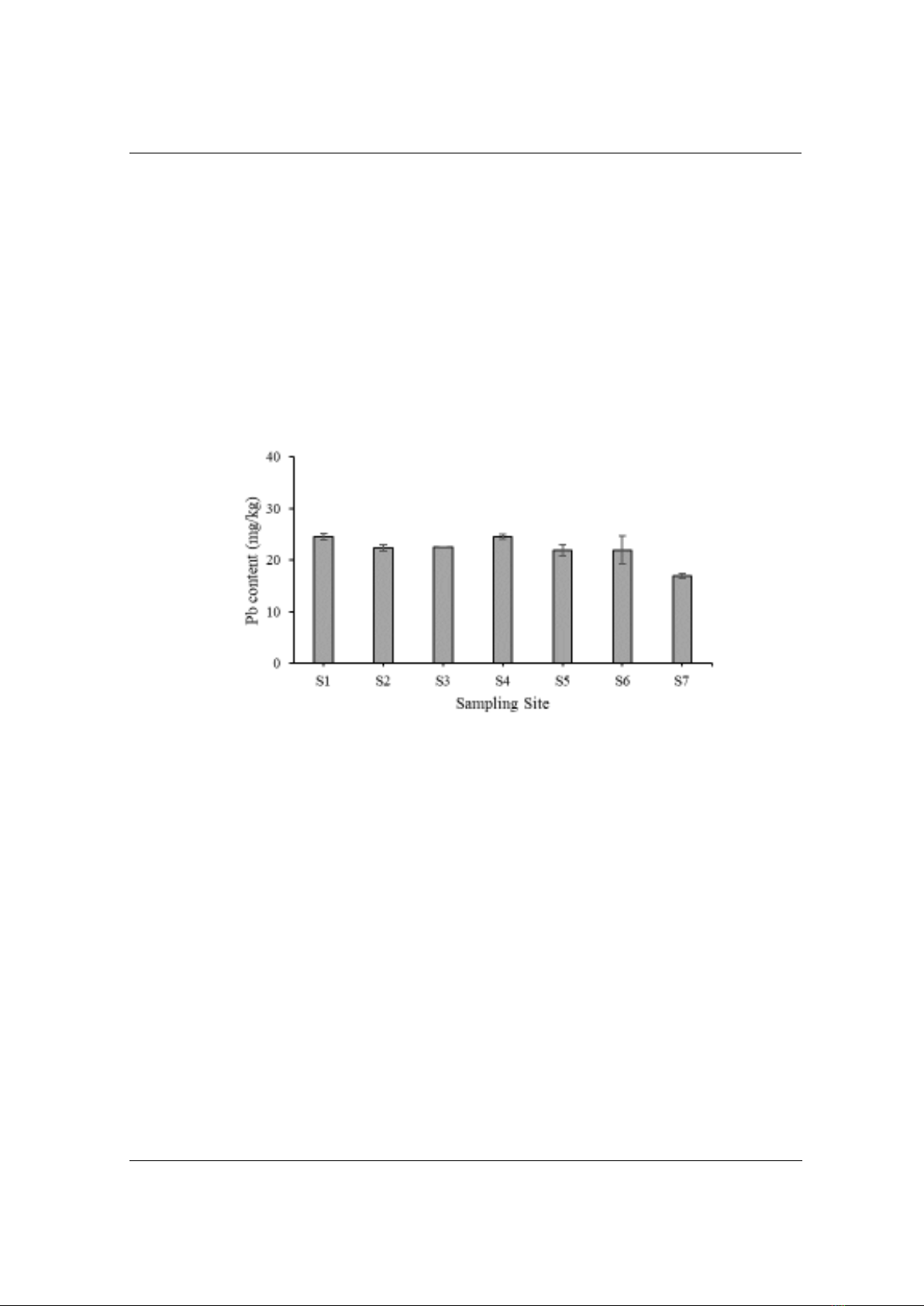
The results shown that the total lead content ranged from 16.92 24.55
mg/kg. We suggest that Pb originated mainly from natural sources
during the weathering process that could be supported by Pb
partitioning in residual fraction silicate bonding i.e., F4 > F3 > F2 >
F1 and geoaccumulation index (Igeo) < 0. The risk assessment code
(RAC) was less than 10% at the sampling sites which indicated low
ecological risks and anthropogenic activities were minor factors that
may influence Pb geochemistry.
Revised:
22/3/2024
Published:
22/3/2024
KEYWORDS
Lead
Sequential extraction
Metal
Sediment
Can Gio
PHÂN BỐ VÀ ĐỊA HÓA CỦA CHÌ TRONG TRẦM TÍCH KÊNH RẠCH
B ẢNH HƯỞNG BI HOẠT ĐỘNG DÂN SINH
THÔNG TIN BÀI BÁO
TÓM TẮT
Ngày nhận bài:
28/11/2023
Các cửa sông có rừng ngp mặn đóng vai trò quan trọng gim thiu cht
ô nhiễm t đất lin ra biển. Tuy nhiên, những thay đổi v tính chất hóa
của nước trầm tích thể nh hưởng đến s phân bố ca chất ô
nhim theo thời gian không gian, bao gồm c kim loi nặng, chúng
thể gây ra rủi ro sinh thái cho sinh vật theo thy triều mùa. Trong
nghiên cứu này, chúng tôi sử dụng phương pháp chiết tun t các phân
đoạn hóa học để đánh giá sự phân b của chì (Pb) rủi ro sinh thái
trong trm tích các con rch b ảnh hưởng bi chế độ thy triều vùng
cửa sông rng ngp mn Cn Gi. Kết qu cho thy m ợng c
tng s dao động trong khong 16.92 24.55 mg/kg, nguồn gc ch
yếu t các nguồn t nhiên được phóng thích tích lũy trong quá trình
phong hóa. Kết luận này thể đưc chứng minh qua hàm ng Pb
liên kết ch yếu với khoáng silicate F4, c th F4 > F3 > F2 > F1
ch s tích lũy địa lý (Igeo) < 0. đánh giá ri ro (RAC) < 10% ti
các điểm ly mu cho thy rủi ro sinh thái của Pb mc thấp các
hoạt động nhân sinh không phải nhân t chính th ảnh hưởng đến
địa hóa học ca Pb.
Ngày hoàn thiện:
22/3/2024
Ngày đăng:
22/3/2024
T KHÓA
Chì
Chiết tun t
Kim loi
Trầm tích
Cn Gi
DOI: https://doi.org/10.34238/tnu-jst.9301
* Corresponding author. Email: ntnho@ntt.edu.vn
TNU Journal of Science and Technology
229(06): 32 - 40
http://jst.tnu.edu.vn 33 Email: jst@tnu.edu.vn
1. Introduction
Estuary is considered an effective buffer zone between land and sea, receiving large amounts
of inorganic and organic matter, and protecting coastal water from pollution. Among pollutants,
heavy metals are one of the main sources that could cause negative impacts on the aquatic and
sediment ecologies [1]. The variability of trace metals is complex due to the influence of different
biogeochemical processes throughout the topography and tidal regime. Because of their potential
toxicity to biodiversity and ecological health, trace metal cycling has become an issue that
scientists have been interested in for recent decades [2].
Mangrove-dominated estuaries provide a distinctive mechanism of trapping sediment that
could carry pollutants and accelerate land-building processes in tide-dominated coastal and
estuarine environments. Industrial wastewater, agricultural and fisheries production industries,
wastewater treatment plants, and leaching from domestic and urban landfills have been reported
as (non)point sources of heavy metals in estuaries that could decrease water and sediment quality,
reproduction, biodiversity, coastal ecosystem function, and human health through the food chain
[3]. During their transport, heavy metals are often distributed in water-soluble, colloidal,
suspended, and sedimentary forms [4]. After deposition in sediments, trace metals can exist in
different mineral bonds: amorphous crystals; adsorption on clay or iron/manganese oxyhydroxide
surfaces; crystal lattice of carbonate, sulfate, or other elemental oxides; organic matter (OM) or
silicate minerals [5] - [7]. Heavy metal association and distribution in sediment depend on pH
[8], salinity [9], redox potential [10], and organic content [11], [12]. In contrast to organic
pollutants, heavy metals are not degraded biologically and chemically and could be thus
transported, deposited, and accumulated in sediments. The cycling, toxicity, bioaccumulation,
persistence, and bioavailability of heavy metals e.g., Pb, Cd, Ni, Cr, and Co, etc. in mangroves
have been studied and reported [13], [14]. However, mangrove sediments are rich in sulphide and
organic matter which modify metal geochemistry after deposition [15], [16]. Therefore,
determining the content and partitioning of heavy metals in the sediment is necessary [17].
In Viet Nam, a developing country, the capacity of water treatment factories is insufficient to
treat the pollutant load e.g., metal(loid)s which are thus discharged to tidal creeks, rivers and
estuaries, from anthropogenic activities. As most of the tropical estuaries are dominated by
mangroves, metal(loid)s can be deposited in these ecosystems. Can Gio is the biggest mangrove
reforestation area in Viet Nam. Many scientists have performed studies on various aspects of the
Can Gio mangrove ecosystem. For example, factors affecting mangrove development and
distribution, mangrove vegetation components and characteristics, and mangrove degradation
[18], [19], the ecological values [20], the impact of hydrology on mangrove structure and
function [21], accretion rates of sediment [22], [23] and also the influences of sedimentary-
physical chemical parameters on the organic nutrient cycles. However, the research on metal
geochemistry was still lacking. Costa-Boddeker et al. [24] reported the current status of metal
accumulation in sediments at the edge of the Can Gio mangrove, showing that the distribution
and accumulation of heavy metals were complex, especially in estuarine regions, where there was
a reciprocal interaction between many factors that disturbed physicochemical properties. The
problems of differences in physicochemical conditions between seasons of the year also help to
better understand the state, evolution and bioavailability of heavy metals. Thanh-Nho et al.
published research on metal content along the mangrove estuary in Can Gio mangrove estuary
[25]. However, previous publications focused only on the total content of metals with out
consideration of their various bond forms in the environment. So, the aims of the present study
were to assess metals i.e, Pb distribution and its geochemistry in tidal creek sediments impacted
by anthropogenic activities. Samples were collected at sites that receive effluents from the
aquacultural and urban activities.
TNU Journal of Science and Technology
229(06): 32 - 40
http://jst.tnu.edu.vn 34 Email: jst@tnu.edu.vn
2. Methodology
2.1. Study area
Can Gio is located in the Southeast of Ho Chi Minh City (10º22'14'' - 10º40'09''N; 106º46'12 ''
- 107º00'59''E) which is a unique district bordering the Eastsea, surrounded by an intricate river
system, such as Long Tau, Soai Rap, Cai Mep, Thi Vai, and Dong Tranh (Figure 1). The area of
Can Gio district is 70,455.34 hectares and can be divided into 3 zones: (1) the core zone has an
area of 4,720 hectares completely covered by mangrove forest which was established with the
long-term purpose of landscape conservation, species biodiversity, and research. Human
activities are prohibited in this zone; (2) the buffer zone with an area of 37,340 hectares is also
covered by mangrove forests, providing a natural landscape, and serving as a cultural and
ecological tourist destination; (3) the transition zone covers an area of about 21,331 hectares,
which is the outermost area with low to dense coverage, and is important for maintaining socio-
economic activities. For socio-economic development, a part of the Can Gio area was exploited
and converted to shrimp farming and residential areas which were considered the direct cause of
disturbing the properties of sediments. These activities can cause disturbance and increase the
content of organic substances as well as the ability to accumulate metal(loid) in sediments. The
process of forest exploitation and conversion to aquaculture leads to increasingly narrowing
forest areas and disturbed sediment properties, increasing the mobility of metals and ecological
risks. Due to their toxicity, bioaccumulation and persistence, trace metals can pose a major threat
to mangrove biodiversity and also to human health. Therefore, it is necessary to better understand
the behavior of metals in the Can Gio mangrove ecosystem.
2.2. Sample collections
The location of sampling sites are exhibited in Figure 1 and the characteristics of each sample
are shown in Table 1. Samples were collected according to TCVN 6663-3:2008 - Water quality -
Sampling - Part 13: Guidance on the sampling of water, wastewater and related sludges.
Sediment cores were collected using a specialized stainless steel tube, each core was divided into
5 sub-samples with depths (i.e., 0-10, 10-20, 20-30, 30-40, and 40-50 cm) and stored in
polyethylene bags. The samples were kept in a cool box and transported to the laboratory. The
sample was dried using a freeze-dryer for 48 hours. After that, the samples were ground and
sieved through 100 µm before analysis. Samples were analyzed at the laboratory of the
Department of Analytical Chemistry, University of Science, Vietnam National University Ho Chi
Minh City.
Table 1. Samples coordinate and characteristic.
Samples
Coordinates
Characteristic
S1
10.618574, 106.841402
The outlet area of the pond and residential area
S2
10.590105, 106.852355
Receiving effluent from shrimp farms and urban
S3
10.571295, 106.814815
The tributary, near shrimp farms and residential areas, connects
the Long Tau River.
S4
10.5127435, 106.75840
Drains, near the wastewater discharge of shrimp ponds, connect
small creeks and rivers.
S5
10.463828, 106.776430
Residential areas, near the outlets of shrimp ponds, and salt fields.
S6
10.423134, 106.825155
The mangrove forest is recovering, near the mouth of the river
adjacent to the sea, surrounded by shrimp and salt farms.
S7
10.543025, 106.830640
Location is considered as a referent sample with limitation of
anthropogenic activities collected in the buffer zone of the Can
Gio mangrove forest.
TNU Journal of Science and Technology
229(06): 32 - 40
http://jst.tnu.edu.vn 35 Email: jst@tnu.edu.vn
Figure 1.
Location of Can Gio mangrove and sampling sites
2.3. Sequential extraction process
Lead
was
divided
into
four
operationally
defined
geochemical
fractions:
an
exchangeable/carbonate fraction (acid-soluble phase), a Fe-Mn oxides fraction (reducible phase),
an
organic
fraction
(oxidizable
phase),
and
a
residual
fraction
(silicate
bonding).
Briefly,
the
various
single
extractions
were
performed
as
follows:
0.5g
of
sediments
were
put
into
50
mL
polypropylene tubes with caps, which were also used for shaking and centrifugation to minimize
the possible loss of the centrifuge washing step. For the determination of the acid-soluble fraction
(F1),
we
used
15
mL
of
0.11
M
CH3COOH/pH
=
5
at
room
temperature
for
1.5h;
for
the
reducible
fraction
(F2),
15
mL
of
0.2M
acid
ascorbic
was
used
during
1.5h;
for
the
oxidizable
fraction (F3), 5 mL of 30% H2O2
and 15 mL of 1 M CH3COONH4
were used at 85 oC during 2h;
for
the
lead
content
in
the
residual
fraction
(F4),
the
samples
was
digested
using
12
mL
of
concentrated
HNO3/HCl
(3:1v/v)
in
polytetra
fluoroethylene
(PTFE)
vessel
at
110
oC
for
24h.
After
that,
the
chemicals
were
eliminated
at
160
oC
to
approximate
a
volume
of
2
mL.
The
sample
was
filtrated
and
then
adjusted
into
25
mL
using
deionized
water,
which
was
stored
in
pre-cleaned polypropylene tubes at 4 oC until analysis [26].
3. Results and Discussions
3.1. Distribution of total lead content
The variability of total lead contents in sediments is shown in Figure 2, ranging from 16.92 to
24.55 mg/kg, in detail: 24.55 ±
0.59 mg/kg (S1), 22.31 ± 0.62 mg/kg (S2), 22.45 ± 0.11 mg/kg
(S3), 24.54 ± 0.53 mg/kg (S4), 21.94 ± 1.10 mg/kg (S5), 21.93 ± 2.71 mg/kg (S6) and 16.92 ±
0.67
mg/kg
(S7).
According
to
QCVN
43/2017
on
lead
content
in
saltwater
sediments
of
112
mg/kg,
the
lead
content
in
Can
Gio
mangrove
sediments
of
the
present
study
was
below
the
TNU Journal of Science and Technology
229(06): 32 - 40
http://jst.tnu.edu.vn 36 Email: jst@tnu.edu.vn
allowable level. The Pb content at site 7 was lower than other ones that could relate to this site
being a forest area not affected by anthropogenic activities. However, it is seen that the increase
of lead content in the study area tends to accumulate over time which could be supported by
higher Pb content than those measured in the Can Gio mangrove (i.e. the lead content was 8 -
20.4 mg/kg) published by Costa-Boeddeker, et al. [27].
In addition, comparing to the Canadian Standards for evaluating risk level of Pb pollution to
the environment, i.e., less than 32 mg/kg: unpolluted, while a higher content suggests 32 48
mg/kg: low risk; 48 64 mg/kg: medium risk; 64 96 mg/kg: high risk, 96 112 mg/kg: very
high risk and > 112 mg/kg: level of influence [28]; for US EPA [29] with Pb risks, i.e., less than
40 mg/kg: unpolluted, 40 60 mg/kg: high risk and > 60 mg/kg: very high risk, all sites of the
present study was at a weak level to no pollution. However, because of low flow and high
sedimentation rates in the tidal creeks controlled by anthropogenic activities as well as lead to
potential human health risks through food chains, it should be limited for land use change to
aquacultural farming and urbanization in the future.
Figure 2.
Variability of total lead content in the creeks
3.2. Partitioning of lead in sediments
Lead
contents
in
the
different
fractions
are
shown
in
Figure
3,
mainly
concentrated
in
a
silicate-bound
form
(F4),
decreased
in the order
F4 >
F3
>
F2
>
F1,
which
was
the form
most
tightly bound to the mineral matrix.
In the residual fraction, the Pb content ranged from 8.07
24.23 mg/kg (i.e., 46.4 -
98.4% of the total content). Lead content in the form bound to organic
matter
varied
from
0.019
-
8.94
mg/kg
(i.e.,
0.088
-
46.13%).
For
the
fraction
of
Fe-Mn
oxyhydroxide, Pb content fluctuated between 0.24
1.34 mg/kg accounting for 0.963 -
7.703%,
while
Pb
content
in
exchangeable/carbonate
phase
changed
from
0.068
-
0.991
mg/kg
corresponding to 0.308 -
5.680% which is easily exchanged under the influence of factors as
pH
[4].
The
lead
distribution
also
changed
between
sites.
At
S1,
S2
and
S4,
the
Pb
was
mainly
concentrated in a silicate-bound form with all depths, which may relate to the limit of influence
by
human
activities
[30].
However,
for
S3,
S5
and
S6,
where
directly
received
effluents
from
urban shown that Pb in the F4 fraction was more variable than those measured at S1, S2 and S4.
Particularly
at
S7,
situating
in
the
mangrove
forest
shown
that
the
lead
distribution in
different
fractions was quite similar with all depths.