Journal of Mining and Earth Sciences Vol. 65, Issue 5 (2024) 61 - 72 61
Establishment of orthophoto map using Lidar
technology combined with digital photography at Tan
Son Nhat Airport, Ho Chi Minh City
Tham Hong Thi Bui1, Nghia Viet Nguyen2, Anh Trung Nguyen3, Thu Hoai Thi Trinh1,*
1 Hanoi University of Natural Resources and Environment, Hanoi, Vietnam
2 Hanoi University of Mining and Geology, Hanoi, Vietnam
3 Survey and Aerial Mapping One Member Limited Liability Company, Hanoi, Vietnam
ARTICLE INFO
ABSTRACT
Article history:
Received 28th Feb. 2024
Revised 02nd July 2024
Accepted 19th Aug. 2024
This article presents a detailed process for generating orthophoto maps
using LiDAR technology alongside digital photography derived from
uncorrected LiDAR data, also referred to as raw data. The process consists
of five main steps: 1. Selection and establishment of control points: Choose
and establish control points for precise georeferencing; 2. Planning and
execution of LiDAR scanning flights: Plan the flight path and parameters
for efficient data collection; 3. Generation of raw point cloud: Following
data collection, the raw point cloud is generated, forming the basis for
subsequent processing and analysis; 4. Orientation and adjustment of the
point cloud data to correct distortions; 5. Creation of an orthophoto map
and accuracy evaluation: In the final phase, increase image control
density to produce orthogonal maps and evaluate accuracy.
This methodology was applied to create orthophoto maps of the Tan Son
Nhat airport area in Ho Chi Minh City, utilizing Trimble's Inpho software
suite. The research results show that the discrepancies in X, Y coordinates
and height (h) between the model values and the measured values for the
25 checkpoints have maximum values of 0.149 m, 0.167 m and 0.169 m,
and minimum values of 0.004 m, 0.005 m, and 0.002 m, respectively. The
difference in the position coordinates and height of the orthophoto map
for the Tan Son Nhat Airport area is less than 10 cm.
With images having a resolution of 0.1 m, the coordinates and heights of
the orthophoto map have small deviations. Therefore, the orthophoto map
in this study has high accuracy, ensuring the creation of maps at a scale of
1:1000 and smaller scales in the experimental area.
Copyright © 2024 Hanoi University of Mining and Geology. All rights reserved.
Keywords:
Digital image,
LiDAR,
Orthophoto map.
_____________________
*Corresponding author
E - mail: tththu@hunre.edu.vn
DOI: 10.46326/JMES.2023.65(5).07

62 Tạp chí Khoa học Kỹ thuật Mỏ - Địa chất Tập 65, Kỳ 5 (2024) 61 - 72
Xây dựng bình đồ ảnh trực giao bằng công nghệ LiDAR kết hợp
chụp ảnh số tại sân bay Tân Sơn Nhất, thành phố Hồ Chí Minh
Bùi Thị Hồng Thắm1, Nguyễn Viết Nghĩa2, Nguyễn Trung Anh3, Trịnh Thị Hoài Thu1,*,
1 Trường Đại học Tài nguyên và Môi trường Hà Nội, Hà Nội, Việt Nam
2 Trường Đại học Mỏ - Địa chất, Hà Nội, Việt Nam
3 Công ty TNHH MTV Trắc địa bản đồ, Hà Nội, Việt Nam
THÔNG TIN BÀI BÁO
TÓM TẮT
Quá trình:
Nhận bài 28/02/2024
Sửa xong 02/7/2024
Chấp nhận đăng 19/8/2024
Bài báo trình bày về quá trình xây dựng bình đồ ảnh trực giao bằng công
nghệ LiDAR kết hợp với chụp ảnh số từ dữ liệu LiDAR chưa được hiệu chỉnh
tín hiệu vật lý (còn gọi là dữ liệu thô). Quá trình thực hiện bao gồm 5 bước
chính: Bước 1. Lựa chọn, xây dựng các điểm khống chế; Bước 2. Thiết kế
bay quét LiDAR, thiết lập các tham số; Bước 3. Tạo point cloud gốc; Bước
4: Định hướng và hiệu chỉnh; Bước 5: Tăng dày khống chế ảnh, thành lập
bình đồ ảnh trực giao, đánh giá độ chính xác.
Quá trình này được áp dụng để xây dựng bình đồ ảnh trực giao khu vực
sân bay Tân Sơn Nhất, thành phố Hồ Chí Minh bằng bộ phần mềm Inpho
của hãng Trimble. Kết quả nghiên cứu cho thấy độ lệch về tọa độ X, Y và độ
cao (h) giữa giá trị mô hình và giá trị đo đạc của 25 điểm kiểm tra có giá
trị lớn nhất lần lượt là 0,149 m, 0,167 m, 0,169 m, giá trị nhỏ nhất lần lượt
là 0,004 m, 0,005 m, 0,002 m. Độ lệch vị trí tọa độ và độ cao của bình đồ ảnh
trực giao khu vực sân bay Tân Sơn Nhất nhỏ hơn 10 cm.
Với ảnh chụp có độ phân giải 0,1 m, tọa độ và độ cao của bình đồ ảnh được
xây dựng có độ lệch nhỏ, do đó bình đồ ảnh trong nghiên cứu này có độ
chính xác cao, đảm bảo cho việc thành lập bản đồ tỷ lệ 1:1000 và các tỷ lệ
nhỏ hơn tại khu vực thực nghiệm.
© 2024 Trường Đại học Mỏ - Địa chất. Tất cả các quyền được bảo đảm.
Từ khóa:
Ảnh số,
Ảnh trực giao,
LiDAR.
_____________________
*Tác giả liên hệ
E - mail: tththu@hunre.edu.vn
DOI: 10.46326/JMES.2023.65(5).07

Bùi Thị Hồng Thắm và nnk./Tạp chí Khoa học Kỹ thuật Mỏ - Địa chất 65 (5), 61 - 72 63
1. Mở đầu
Công nghệ LiDAR (Light detection and
Ranging) đã tồn tại từ những năm 1960
(Mehendale và Neoge, 2020). Công nghệ này sử
dụng tia laser để đo khoảng cách và tạo ra hình
ảnh chi tiết về địa hình, mặt đất cũng như các đối
tượng khác trên bề mặt trái đất. Đặc điểm của
công nghệ LiDAR là cho phép thu thập dữ liệu
chính xác, chi tiết cao, không cần trực tiếp tiếp xúc
với đối tượng cần khảo sát nên nó được ứng dụng
trong nhiều lĩnh vực như:
- Giao thông, cơ sở hạ tầng:
Công nghệ LiDAR được sử dụng: trong thiết
kế các đường bay dân dụng ở Malaysia (Hatta
Antah và nnk., 2021); trong kiểm tra, giám sát theo
dõi tình trạng kết cấu của các cơ sở hạ tầng dân
dụng bao gồm cầu, đường và vỉa hè, đường hầm
và cấu trúc vòm, đánh giá sự an toàn và tính toàn
vẹn của cơ sở hạ tầng dân dụng (Kaartinen và
nnk., 2022); trong khảo sát thiết kế cầu Pingtang
Grand ở Trung Quốc (Ding và Zhang, 2023); trong
giám sát toàn bộ vòng đời của đường sắt (Li,
2020); trong hỗ trợ các cơ quan vận tải trong các
giai đoạn thiết kế, xây dựng và bảo trì các dự án
giao thông (McIntosh và Rister, 2022); trong phát
triển đường cao tốc, đường dây truyền tải và đập
thủy điện (Ganendra và Mobarakeh, 2018).
- Đất đai, quản lý đô thị:
Công nghệ LiDAR được sử dụng để: đo lường
và giám sát tài nguyên đất đai theo thời gian thực
(Wei và Guo, 2018); thành lập bản đồ địa chính
khu vực nông thôn phục vụ cho công tác địa chính
tại khu vực (He và Li, 2020). Công nghệ này kết
hợp với: dữ liệu ảnh hàng không, ảnh vệ tinh, bản
đồ… để xây dựng mô hình 3D khu vực đô thị, bản
đồ không gian ba chiều khu vực đô thị tại thành
phố Bắc Giang (Đặng và nnk., 2014), tại khu vực
phường Thượng Lý, quận Hồng Bàng, thành phố
Hải Phòng (Dương và nnk., 2022); công nghệ GPS,
GIS và AI để cung cấp dữ liệu nhanh chóng và
chính xác giúp các nhà quản trị và quy hoạch đưa
ra những quyết định (Prim và nnk., 2021); ảnh
chụp mặt đất để xây dựng dữ liệu không gian địa
lý 3D theo tiêu chuẩn CityGML khu vực Hạ
Long,Quảng Ninh (Nguyễn và nnk., 2022).
- Địa chấn, địa chất:
Công nghệ LiDAR được sử dụng: xây dựng mô
hình số độ cao phục vụ cho việc xác định dạng địa
hình, đặc điểm cấu trúc địa mạo, nghiên cứu đứt
gãy, địa chấn tại khu vực rìa phía bắc của dãy núi
Qinling và vùng đứt gãy Huashan Piedmont
(Wang và nnk., 2020); xây dựng bản đồ địa hình,
tính toán độ dốc phục vụ cho thăm dò địa chấn tại
lưu vực sông Green ở Wyoming (Wagaman và
Sfara, 2005); thành lập bình đồ ảnh trực giao độ
phân giải cao giúp nâng cao việc lập kế hoạch để
thu thập địa chấn và quản lý vận hành tại hiện
trường ở phía nam Trung Quốc (Gaoming và nnk.,
2022); thành lập dữ liệu địa hình có độ phân giải
cao để xác định các đặc điểm cấu trúc vi mô và địa
mạo, phân tích hoạt động vùng đứt gãy và đánh giá
thảm họa động đất ở Tân Cương, Trung Quốc
(Wen và nnk., 2022); thu thập dữ liệu và xác định
trượt lở đất nhằm xác định sớm các mối nguy
hiểm địa chất ở khu vực núi cao (Wang và nnk.,
2020).
- Đo đạc, bản đồ:
Công nghệ LiDAR được sử dụng: đo đạc và
thành lập bản đồ địa hình có độ phân giải cao được
sử dụng đa dạng bao gồm quy hoạch phát triển,
công trình kỹ thuật, quản lý môi trường, quản lý
thiên tai, quy hoạch đô thị, thủy lợi, nghiên cứu địa
chất, nghiên cứu khảo cổ học và ứng dụng địa
chính tại Nepal (Joshi và Koirala, 2020); thành lập
mô hình số độ cao khu vực thành phố Bắc Giang
(Bùi và nnk., 2010); phân loại lớp phủ bề mặt khu
vực đô thị (Nguyễn và Nguyễn, 2022a); thành lập
ảnh trực giao, mô hình 3D của bề mặt Trái đất có
mức độ chi tiết, sắc nét và độ chính xác cao cho nhà
ga sân bay Liên Khương (Nguyễn và Nguyễn,
2022b); thành lập bản đồ và phân tích địa hình tại
Malaysia (Hassan và Syed, 2021); thành lập mô
hình số độ cao, bản đồ cấu trúc địa mạo, kết xuất
tòa nhà, tích hợp mô hình toán học, thông số thực
vật trên phạm vi rộng và độ chính xác cao (Hill và
nnk., 2020).
- Nghiên cứu khí quyển:
Công nghệ LiDAR được sử dụng: xây dựng mô
hình số độ cao hỗ trợ cho việc nghiên cứu khí
quyển ở Ấn Độ (Purwar, 2018); quan trắc ô nhiễm
không khí tại thành phố Hồ Chí Minh (Lê, 2022).
Bên cạnh đó, công nghệ LiDAR còn được sử
dụng trong rất nhiều các công việc khác như: giám
sát các tòa nhà, đê, bờ sông, đường xây dựng -

64 Bùi Thị Hồng Thắm và nnk./Tạp chí Khoa học Kỹ thuật Mỏ - Địa chất 65 (5), 61 - 72
những đối tượng có ảnh hưởng rất lớn tới động
lực học dòng chảy, lan truyền lũ để mô hình hóa lũ
phục vụ cảnh báo thiên tai (Trần, 2010); giám sát
các cuộc thử nghiệm phóng tên lửa phục vụ cho
lĩnh vực an ninh quốc phòng (Ren và nnk., 2022);
trong quản lý vận hành đường dây truyền tải điện
(Nguyễn, 2021).
Có thể thấy công nghệ LiDAR được ứng dụng
trong đa dạng các lĩnh vực. LiDAR cho phép đo đạc
độ cao của địa hình một cách chi tiết, nhanh chóng
và chính xác vì vậy bản đồ địa hình, cơ sở dữ liệu,
hình ảnh mô phỏng địa hình khu vực cũng có độ
chính xác và độ tin cậy cao. Đi kèm với các hệ
thống bay quét LiDAR là các bộ phần mềm xử lý
dữ liệu. Hiện nay tại Việt Nam tồn tại phần mềm
thương mại và phần mềm mã nguồn mở để xử lý
dữ liệu LiDAR. Tuy nhiên, cả hai loại phần mềm
này chỉ xử lý được dữ liệu sau khi đã được hiệu
chỉnh tín hiệu vật lý mà không xử lý được dữ liệu
thô từ máy quét LiDAR. Bên cạnh đó, mặc dù dữ
liệu LiDAR có mật độ điểm dày đặc chứa đựng các
thông tin về đối tượng địa lý nhưng đường viền
của các đối tượng không sắc nét trong khi đó ảnh
số lại giải quyết được vấn đề này. Chính vì vậy bài
báo này nghiên cứu đề xuất quy trình xử lý dữ liệu
LiDAR kết hợp với ảnh số từ dữ liệu thô và áp dụng
nó để thành lập bình đồ ảnh trực giao khu vực sân
bay Tân Sơn Nhất, thành phố Hồ Chí Minh.
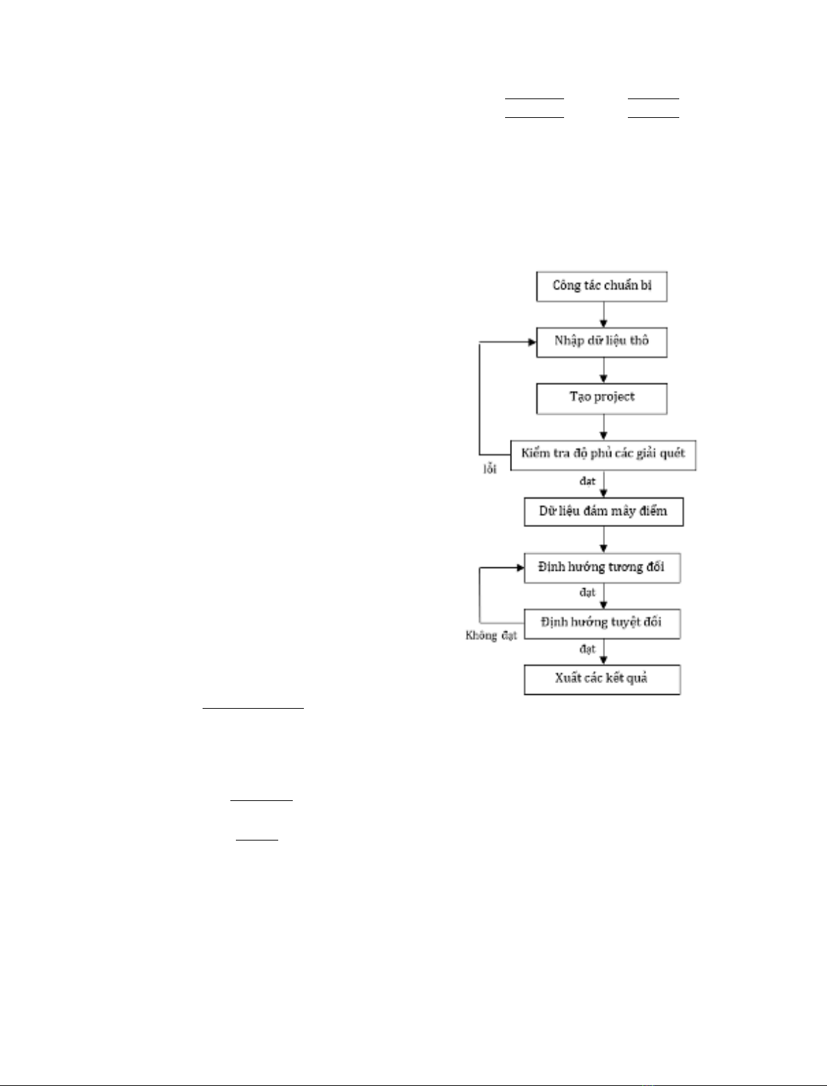
2. Phương pháp nghiên cứu
Quá trình thành lập bình đồ ảnh trực giao
được thực hiện theo các bước sau:
Bước 1: Lựa chọn, xây dựng các điểm khống chế.
Điểm khống chế tọa độ, độ cao được sử dụng
làm điểm gốc phục vụ cho việc định hướng bay
quét LiDAR, xây dựng bình đồ ảnh trực giao. Các
điểm khống chế tọa độ, độ cao được lựa chọn, bố
trí tại những nơi có nền đất vững chắc, ổn định tại
khu vực thực nghiệm, được đo nối với lưới khống
chế trắc địa quốc gia để xác định tọa độ và độ cao
trong hệ tọa độ và độ cao quốc gia.
Bước 2: Thiết kế bay quét LiDAR, thiết lập các tham
số.
- Việc thiết kế bay quét LiDAR được tính toán,
thiết kế trên bản đồ phù hợp với địa hình của khu
vực bay.
- Thiết kế đường bay, hướng bay trong khu
- Thu thập dữ liệu: Dữ liệu LiDAR gốc; dữ liệu
tính toán quỹ đạo bay quét (post-processing
solution); dữ liệu ảnh chụp; dữ liệu đo đạc bãi
chuẩn hiệu chỉnh; tham số kiểm định hệ thống bay
quét.
- Thiết lập công việc, các tham số.
- Tạo và kiểm tra độ phủ các dải quét: Tạo các
giải quét, kiểm tra độ chồng phủ của chúng để phát
hiện những vấn đề còn tồn tại về dữ liệu.
Bước 3: Tạo point cloud gốc.
Quá trình này tạo ra tập hợp các đám mây
điểm gốc từ máy quét bằng cách đọc dữ liệu LiDAR
gốc được mã hóa sau đó được chuyển đổi về hệ tọa
độ và độ cao địa phương.
Bước 4: Định hướng và hiệu chỉnh.
- Định hướng tương đối tự động: Tính toán,
hiệu chỉnh tự động khớp tất cả các dải quét có độ
chồng phủ nhất định để xử lý đưa ra mô hình độ
cao. Đây là công việc phân tích, tìm kiếm các vùng
địa vật có chênh cao (mặt nghiêng) trong phạm vi
chồng phủ sau đó tự động điều chỉnh, khớp với các
địa vật giống nhau trong các dải quét và tính toán
kết quả bù trừ để tất cả các dải quét được liên kết
với nhau một cách gần đúng nhất.
- Định hướng tương đối thủ công: Hiệu chỉnh
bình sai các dải quét kết hợp với dữ liệu bãi chuẩn
hiệu chỉnh mặt đất. Tất cả các giá trị (X,Y,H) của
từng dải bay/từng point cloud được hiệu chỉnh để
đưa về giá trị tọa độ chính xác nhất theo hệ tọa độ
yêu cầu. Việc hiệu chỉnh này được chia thành 2
công đoạn:
+ Hiệu chỉnh mặt phẳng: Hiệu chỉnh các đám
mây điểm kết hợp dữ liệu tham chiếu mặt đất.
Hình ảnh có độ phân giải cao của đám mây điểm
được hiển thị và các đa giác hình ảnh tòa nhà hoặc
các đại vật hình khối tham chiếu được phủ lên đó
một cách trực quan giúp người dùng có thể hiệu
chỉnh, xê dịch theo nó một cách dễ dàng.
+ Hiệu chỉnh độ cao: Tất cả các dải quét được
hiển thị bằng hình ảnh và được quy định các màu
sắc khác nhau dễ dàng cho việc nâng hạ cả dải quét
theo phương thẳng đứng để có được sự trùng khít
và phù hợp nhất giữa các dải quét.
- Định hướng tuyệt đối mô hình độ cao: Dựa
vào các tham số tham chiếu của bãi hiệu chỉnh độ
cao mặt đất việc bình sai và hiệu chỉnh được thực
hiện để đưa ra sai số về sự chênh lệch độ cao trung
bình giữa mô hình được tính toán và các giá trị độ
Bùi Thị Hồng Thắm và nnk./Tạp chí Khoa học Kỹ thuật Mỏ - Địa chất 65 (5), 61 - 72 65
cao thực tế. Sự chênh lệch trung bình này được bù
trừ vào mô hình tính toán để dịch chuyển toàn bộ
các dải quét theo hướng thẳng đứng một cách
chính xác nhất. Toàn bộ quá trình và các tham số
về độ lệch này được ghi trong file báo cáo chi tiết
và cụ thể giúp người dùng đưa ra đánh giá xác
thực nhất về kết quả xử lý dữ liệu.
Bước 5: Tăng dày khống chế ảnh, thành lập bình đồ
ảnh trực giao, đánh giá độ chính xác.
- Công nghệ LiDAR sẽ sử dụng trực tiếp DSM,
DEM từ dữ liệu LiDAR để nắn ảnh. Toàn bộ tâm
ảnh tuyệt đối sau hiệu chỉnh bình sai sẽ được sử
dụng cho công tác tăng dày. Làm hạn chế công tác
đo đạc khống chế ảnh ngoại nghiệp, tạo tính đồng
bộ giữa dữ liệu LiDAR và bình đồ ảnh.
- Bình đồ ảnh trực giao là một trong sản phẩm
của quá trình thực hiện nêu trên. Các sản phẩm
khác của quá trình này gồm point cloud sau hiệu
chỉnh, DSM/DTM, quỹ đạo và các tham số định
hướng tuyệt đối.
Độ chính xác của bình đồ ảnh trực giao được
xác định thông qua quá trình so sánh tọa độ, độ
cao được chiết xuất từ DSM/DTM của các điểm
khống chế được sử dụng làm điểm kiểm tra với
các giá trị tương ứng đo đạc, cụ thể như sau:
- Tính độ lệch về tọa độ (∆X, ∆Y) và độ cao
(∆h):
∆𝑋𝑖= 𝑋𝑖𝑠𝑢𝑟 −𝑋𝑖𝑚𝑜𝑑𝑒𝑙
∆𝑌𝑖=𝑌𝑖𝑠𝑢𝑟 −𝑌𝑖𝑚𝑜𝑑𝑒𝑙
∆ℎ𝑖=ℎ𝑖
𝑠𝑢𝑟 −ℎ𝑖
𝑚𝑜𝑑𝑒𝑙
(1)
- Tính độ lệch về mặt phẳng (∆XY):
∆𝑋𝑌𝑖=√(∆𝑋𝑖)2−(∆𝑌𝑖)2
(2)
- Tính giá trị trung bình độ lệch về mặt phẳng
(∆𝑋𝑌𝑎𝑣𝑒𝑟) và độ cao (∆ℎ𝑎𝑣𝑒𝑟):
∆𝑋𝑌𝑎𝑣𝑒𝑟 =∑∆𝑋𝑌𝑖
𝑛
𝑖=1𝑛
∆ℎ𝑎𝑣𝑒𝑟 =∑∆ℎ𝑖
𝑛
𝑖=1
𝑛
(3)
- Tính các giá trị hiệu chỉnh về mặt phẳng
(VXY) và độ cao (Vh):
V𝑋𝑌𝑖=∆𝑋𝑌𝑎𝑣𝑒𝑟 −∆𝑋𝑖
Vℎ𝑖=∆ℎ𝑎𝑣𝑒𝑟 −∆ℎ𝑖
(4)
- Tính sai số trung phương về mặt phẳng
(𝑚𝑋𝑌) và độ cao (𝑚ℎ):
𝑚𝑋𝑌 =√∑[𝑉𝑋𝑌
𝑛
𝑖=1 ]2
𝑛−1 ; 𝑚ℎ=√∑[𝑉ℎ
𝑛
𝑖=1 ]2
𝑛−1
⬚
(5)
Trong đó: 𝑋𝑖𝑠𝑢𝑟,𝑌𝑖𝑠𝑢𝑟,ℎ𝑖
𝑠𝑢𝑟 - tọa độ, độ cao đo
đạc của điểm kiểm tra thứ i;
𝑋𝑖𝑚𝑜𝑑𝑒𝑙,𝑌𝑖𝑚𝑜𝑑𝑒𝑙,ℎ𝑖
𝑚𝑜𝑑𝑒𝑙 - tọa độ, độ cao trên mô
hình của điểm kiểm tra thứ i.
Quá trình xử lý dữ liệu LiDAR được mô hình
hóa dưới dạng sơ đồ quy trình thể hiện tại Hình 1.
3. Dữ liệu nghiên cứu
Phạm vi nghiên cứu trong bài viết là khu vực
sân bay Tân Sơn Nhất, thành phố Hồ Chí Minh
được thể hiện tại Hình 1. Dữ liệu được sử dụng
phục vụ cho nghiên cứu gồm:
- 05 điểm khống chế ảnh và 25 điểm kiểm tra
được bố trí như sơ đồ Hình 2. Tọa độ và độ cao của
các điểm này được thể hiện tại Bảng 1.
- 432 ảnh của 7 tuyến bay được chụp từ máy
chụp ảnh Rollei AIC P45. Các tuyến bay này có độ
phủ ngang nằm trong khoảng 35÷40%,
Hình 1. Sơ đồ quy trình xử lý dữ liệu LiDAR.


![Chương trình đào tạo cơ bản Năng lượng điện mặt trời mái nhà [mới nhất]](https://cdn.tailieu.vn/images/document/thumbnail/2026/20260126/cristianoronaldo02/135x160/21211769418986.jpg)

![Chương trình đào tạo cơ bản Năng lượng gió [Tối ưu SEO]](https://cdn.tailieu.vn/images/document/thumbnail/2026/20260126/cristianoronaldo02/135x160/53881769418987.jpg)


