Vietnam Journal
of Agricultural
Sciences
ISSN 2588-1299
VJAS 2023; 6(4): 1931-1945
https://doi.org/10.31817/vjas.2023.6.4.04
1931
Vietnam Journal of Agricultural Sciences
Received: February 27, 2023
Accepted: November 18, 2023
Correspondence to
nthngoc@vnua.edu.vn
The Dispersion of Total Suspended Solids in
Seawater Following Submersion of Dredged
Material in the Vung Ang Port
Nguyen Thi Hong Ngoc1 & Tran Anh Quan2
1Faculty of Natural Resources and Environment, Vietnam National University of
Agriculture, Hanoi 131000, Vietnam
2Faculty of Environment, Hanoi University of Mining and Geology, Hanoi 130500, Vietnam
Abstract
Dredging plays a crucial role in port management, but disposing
dredged material in the ocean raises environmental concerns. In
recent years, this practice has become more prevalent in Vietnam.
This study examined the dispersion of total suspended solids (TSS)
in seawater from the submersion of dredged material in Vung Ang
Port, northern Vietnam, to evaluate the environmental impact. The
study utilized MIKE modeling to simulate the dispersion of TSS
during the 16 weeks following the submersion of dredged material
into the sea. The model was validated with observed data and
adjusted to accurately reproduce wave, water flow, and water level
fields. The simulation showed that the propagation of TSS had a
significant impact within a radius of 16-17km from the submersion
location, with the most severe impact occurring within a radius of 2-
3km. The TSS concentration is expected to exceed allowable limits,
peaking after 4-5 weeks. Seawater occupation will reach maximums
of 49.05ha and 140.66ha for depth increases above 0.5m and 0.1m.
The submersion will negatively impact the environment. It is
essential to regularly monitor TSS in affected areas during and after
dredging to evaluate long-term effects and mitigation effectiveness.
The significance of conducting additional research on the matter and
the crucial insights offered by this study to pertinent management
agencies for their decision-making processes are emphasized in
the article. The study offers crucial insights for pertinent
management agencies.
Keywords
TSS, submersion, port, MIKE, modeling
Introduction
In recent years, seabed dredging has become an increasingly
crucial aspect of port management and operations in Vietnam. The
removal of sediment, sand, and other debris from the seabed is crucial

The dispersion of total suspended solids in seawater following submersion of dredged material in the Vung Ang port
1932
Vietnam Journal of Agricultural Sciences
for maintaining or deepening navigable channels,
which ensures the safe passage of ships and the
smooth flow of goods and materials. The Vung
Ang port in northern Vietnam is a critical hub for
the region, and its dredging and maintenance
activities play a crucial role in ensuring its
efficient operation. The 2020 Vung Ang shipping
channel dredging project was designed to
improve navigational safety and accessibility
within the port by removing 205,215m3 of
sediment to a depth of -12m, within the turning
basin and shipping channel from Km 2+400 to
Terminal 2. To minimize the environmental
impact of the dredging, the Ha Tinh Provincial
People's Committee approved the relocation of
the dredged material to an area 38 km away,
outside the monitoring zone for environmental
recovery. The designated dumping site, located
within a 100ha area (1km x 1km), was approved
by Decision No. 7827/UBND-GT1 dated
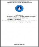
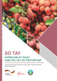
November 22, 2019 (Figure 1). The proper
implementation of this dredging project
contributed to the continued success and
development of the Vung Ang port.
One of the primary reasons for the need for
seabed dredging in Vung Ang port is the increase
in shipping traffic. With the rise in global trade
and commerce, there has been a corresponding
increase in the volume of ships entering and
leaving ports around the world. In order to
meet this demand, seabed dredging is
necessary to deepen the navigable channels and
to ensure that they are capable of
accommodating larger ships (Prumm &
Gregorio, 2016; Samsami et al., 2022).
Another factor that contributes to the need
for seabed dredging in Vung Ang port is
sedimentation. The accumulation of sediment,
sand, and other debris in the waterways can
reduce the depth of the channel and make it
difficult for ships to navigate. This sedimentation
can also cause the formation of shoals and other
navigational hazards, which pose a risk to
shipping operations in the port. To mitigate this
risk, regular dredging is necessary to remove the
accumulated sediment and to maintain the depth
and navigability of the channels (Yuwei et al.,
2022). Maintenance of navigable channels is
another key reason for the need for seabed
dredging in Vung Ang port. Dredging helps to
remove the accumulated sediment and debris,
which ensures that the channels remain free from
navigational hazards and remain navigable
(Kamal & Nahla, 2018; Vinh & Lan, 2018).
Regular maintenance dredging also helps to
ensure that the channels remain clear and free
from obstructions, which is crucial for the safety
and efficiency of shipping operations in the port
(Ren et al, 1996; Rydningen et al., 2015). Due to
the impacts of climate change, Vietnam is
considered one of the countries most affected by
global warming and sea level rise (Tran Anh &
Taniguchi, 2014; Tran-Anh et al., 2022; Tran-
Anh et al., 2023). Therefore, it is increasingly
important to thoroughly study the harmful effects
of materials sinking in the sea.
The dumping of dredged material in the
ocean is a common practice in many ports and
harbors around the world, including in Vietnam.
This process involves the disposal of sediment,
sand, and other debris that has been removed
from the sea floor during dredging operations.
The importance of dumping dredged material in
the ocean is linked to several key factors,
including the need for safe and efficient
navigation, the protection of the marine
environment, and the management of waste from
dredging operations (Bortali et al., 2023). In
recent years, mounting concern has arisen over
the environmental consequences of seabed
dredging and subsequent dumping of dredged
material into the ocean. A major focal point of
this concern revolves around the dispersion of
total suspended solids (TSS) in the water column,
which can have adverse effects on aquatic
ecosystems and human well-being. Despite the
significance of this issue, the available literature
on the subject is severely limited, emphasizing
the critical need for further research. To provide
clarity and insight into this issue, a noteworthy
study by Tran Dinh Lan et al. (2020) explored the
dispersion of TSS in the East Sea subsequent to
the dumping of dredged material from the Port of
Hai Phong. The findings revealed a substantial
increase in TSS concentrations in the vicinity of
the dumping site, with elevated levels persisting
for an extended period. Additionally, the study
underscored the influential role played by the
Nguyen Thi Hong Ngoc & Tran Anh Quan (2023)
https://vjas.vnua.edu.vn/
1933
Figure 1. Map of the study area, the small black rectangle indicates the dumping site for dredged material
size and direction of water currents in the
dispersion of TSS, enhancing our understanding
of the complex dynamics at play. Similarly, Kim
et al. (2018) conducted a study on the dispersion
of TSS resulting from the dumping of dredged
material in the East China Sea. Their findings
demonstrated a significant rise in TSS
concentrations in the water column immediately
after the dumping, with the highest
concentrations observed closest to the dumping
site. As time elapsed, TSS concentrations
gradually decreased as the material dispersed
away from the site, providing valuable insights
into the temporal aspects of TSS dispersion.
Considering the limited research available on this
critical issue, both studies have contributed
significantly to the understanding of TSS
dispersion resulting from dredged material
dumping in marine environments. Their findings
emphasize the importance of investigating
similar scenarios, such as the Vung Ang port
dredging project, to evaluate potential
environmental impacts and inform responsible
decision-makers regarding dredged material
disposal. As a result, further research in this area
is of paramount importance in promoting
sustainable practices and safeguarding the
delicate balance of maintaining marine
ecosystems and human health.
The significance of this study lies in its
investigation of the dispersion of TSS resulting
from the submersion of dredged material in the
Vung Ang Port. The study utilized the MIKE
modeling system and observed data to simulate
the TSS submersion process, offering crucial
insights into the extent and severity of pollution
propagation at the dredging and submersion
locations. By highlighting the environmental
concerns related to dredged material disposal and
the significant impacts of disposal on marine
ecosystems and water quality, the study offers
valuable information for relevant management
agencies to make informed decisions about port
dredging practices and the implementation of
effective environmental conservation measures.
Materials and Methods
Sampling
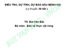
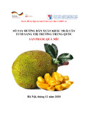
On June 15, 2019, four mud and seawater
samples were collected within the scope of the

The dispersion of total suspended solids in seawater following submersion of dredged material in the Vung Ang port
1934
Vietnam Journal of Agricultural Sciences
discharge flow, ranging from Km1+050 to buoy
PN14 before docks 3 and 4. The discharge flow
covered a total length of approximately 3.75km
and had 83 cross-sections along its path, with
cross-sections 59-73 located in the ship's turning
basin before Dock 2. To ensure accurate analysis,
the samples were collected at a depth of -11m,
with each sample weighing 200g and a reserve of
10 kg. To guarantee a fair and unbiased selection
of sample sites, all four sample sites were
randomly picked on the grid map (Figure 2),
ensuring representation of the entire flow path
and allowing for an assessment of the uniformity
of potentially polluted areas.
TSS dispersion model
In order to accurately model the processes of
sediment transport, erosion, and deposition of
non-cohesive sediment in both marine and
freshwater environments, we employed the state-
of-the-art simulation tool, MIKE 21MT (DHI,
2017). The MIKE model is a widely used
numerical modeling tool for simulating
hydrodynamic and water quality processes in
aquatic environments. In the context of studying
sediment dispersion, the MIKE model assumes
steady-state or quasi-steady-state flow
conditions, uniform sediment properties, and a
uniform bed. It may neglect small-scale
turbulence effects and sediment-fluid
interactions, while assuming constant physical
characteristics of the study area. These
simplifications enable efficient simulations while
aiming to represent real-world conditions as
accurately as possible. Calibration and validation
against real data are essential for assessing the
model's accuracy and reliability. MIKE 21MT
can be dynamically linked to the hydrodynamic
and wave modules of the Mike program, utilizing
either a finite element or rectangular finite
difference calculation mesh with the option to
perform the simulations in either 3D or 2D. The
hydrodynamic foundation of the module is based
on the MIKE 21HD FM and MIKE 3HD FM
models. Given the significance of wave impact
on the erosion process, wave parameters were
taken into consideration and were obtained from
the frequency-domain wave calculation module
Mike21SW. The sediment transport equation
utilized in Mike is outlined in Teisson (1991):
where t is the time; u, v, and w are the
velocity components of the flow; ci is the
concentration component of the sediment i; wis
is the sedimentation velocity; 𝛿𝑇𝑥
𝑖 is the Schmidt
number; 𝜐𝑇𝑥 is the viscosity coefficient; and Si
is the source term coefficient. The process of
non-cohesive sediment transport is solved by
the algorithm of the particle transport
calculation module.
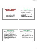
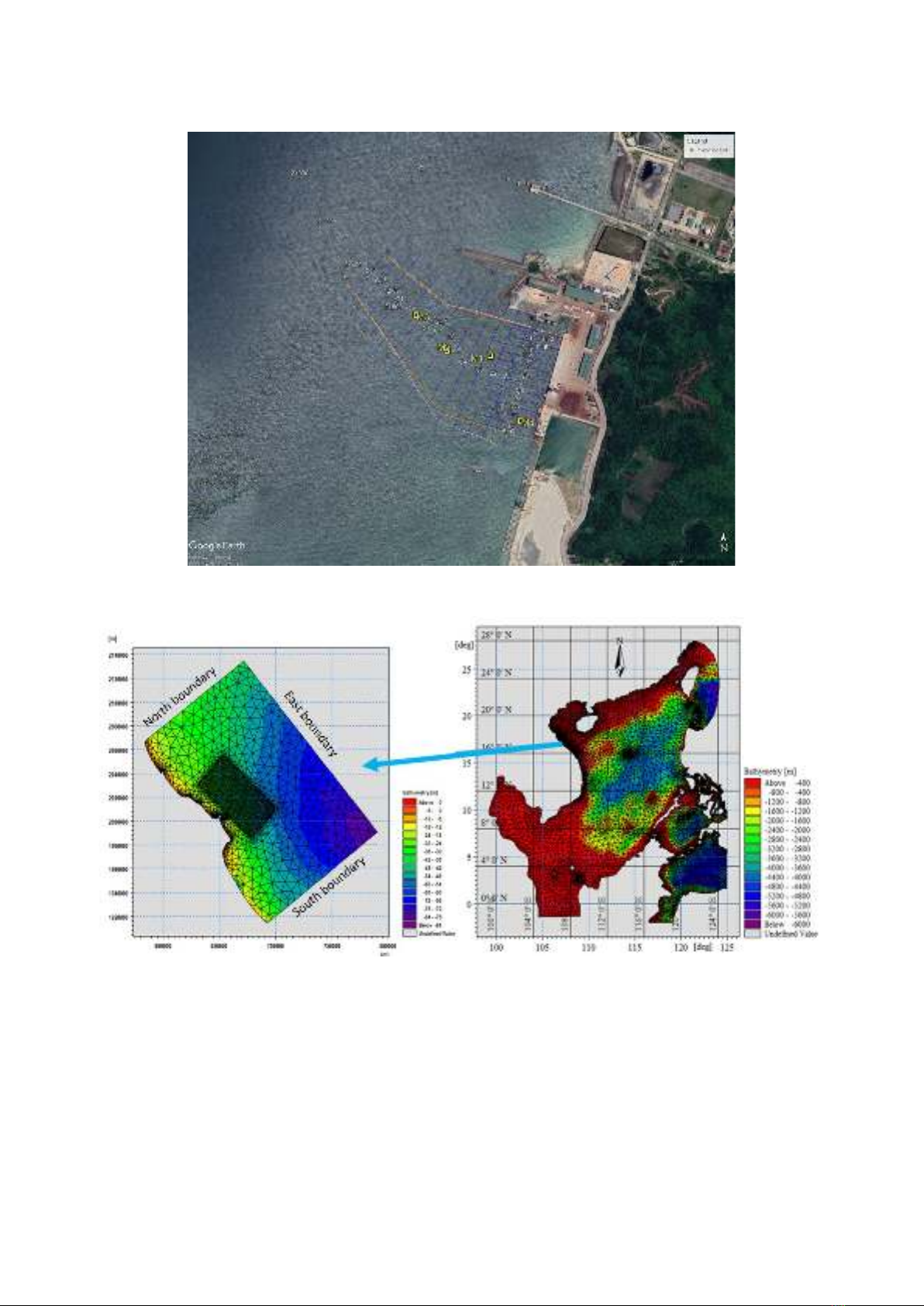
The modeling domain and boundaries of the
3D coastal model
To ensure the accuracy of the tidal
simulation in the Central Vietnam region, the
model's domain covered not only the project area
but also included the East Sea area outside,
taking into account the tidal propagation from the
various estuaries (Figure 3). The finite element
grid was applied, with finer grids in shallow areas
and coarser grids in deep areas. The smallest grid
cell size was 100m in nearshore areas where
erosion and deposition occur and the largest was
4km in the middle of the East Sea. The nested
domain encompassed the coastal region of the
Vung Ang port area, with the Formosa-Ha Tinh
plant as its central point. The nested domain
extended in both the northern and southern
directions to capture the space that had the
potential to transmit pollutants and maintain the
integrity of the boundaries.
Using the finite element method, the
computational mesh was constructed using
36,948 grid nodes and the grid resolution was
optimized to suit the area of interest. The grid
resolution varied from coarse to fine, with a
minimum grid size of 40m and a maximum grid
size of approximately 3000m in the deep-water
oceanic regions. The numerical simulations were
conducted in three vertical layers.
Hydro-dynamic boundaries
In order to predict the tidal water levels at the
coastal inlets in the East Sea, a numerical
modeling approach was employed using the
Nguyen Thi Hong Ngoc & Tran Anh Quan (2023)
https://vjas.vnua.edu.vn/
1935
Figure 2. Sampling location of mud and seawater
Figure 3. Computation grids for the East Sea (right) and the Vung Ang port (left)
advanced Mike21 Tidal tool. The surface
boundary conditions, including wind and
pressure data, taken from the ERA5 reanalysis
dataset, were analyzed using a 3-hour time step
to capture the variability of these parameters. At
the detailed scale of the nested domain, the flow
and water level boundary conditions were
represented by the MIKE 3HD FM model, which
consisted of the flux components along the
boundary elements obtained from a
comprehensive analysis of the East Sea.
The computational boundary of the Quyen
River was defined by collecting the average
monthly volume data from a hydrometric station