
Journal of Mining and Earth Sciences, Vol 66, Issue 2 (2025) 39 - 49 39
Assessment of a rock planar slide along an
expressway in Vietnam
Nghia Tuan Do 1,*, Lan Chau Nguyen 2, Tuan Quang Nguyen 1, Dinh Quoc Nguyen 3
1 Thuyloi University, Hanoi, Vietnam
2 University of Transport and Communications, Hanoi, Vietnam
3 Phenikaa University, Hanoi, Vietnam
ARTICLE INFO
ABSTRACT
Article history:
Received 24th Nov. 2024
Revised 06th Mar. 2025
Accepted 21st Mar. 2025
This paper presents an assessment of a rock planar slide, which took place at
km 108 along the Tien Yen-Mong Cai expressway, an extension of the Halong-
Vandon expressway in Vietnam. Half of the expressway has been covered by
a large volume of rock deposit after its movement. The height of the slope in
this study is 16 m and its width is 200 m. The main head scarp is about 11 m
high. The sliding angle of the failure surface is from 12÷150. The stratigraphy
mostly consists of weathered jointed siltstone, which is located in the upper
part of the Ha Coi formation (J1-2hc2). The sedimentary rocks are thick
bedded, fine-grained sandstones interbedded with medium-bedded
chocolate pink siltstones or thin-bedded shales. In general, they are medium
to thick bedded with the thickness of rock layer from 0.3÷0.8 m. The upper
rock layer is the 9b-1 layer with RQD = 0÷36% whereas the lower one is the
9b-2 layer with RQD = 0÷92%. The topsoil layer is 0.5÷2.5 m thick. Rockplane
and Plaxis computer softwares were adopted to perform stability analysis of
the slope. Results showed that the overall factor of safety of the slope before
treatment is lower than 1.0, which is in good agreement with the instability
of the slope. In order to apply the countermeasures, part of the slope will be
first excavated with an angle of 450. Then, the prestressed ground anchor
system will be installed. After treatment, the overall factor of safety of the
slope was increased to larger than 1.30, which meets the requirement by the
Vietnam code.
Copyright © 2025 Hanoi University of Mining and Geology. All rights reserved.
Keywords:
Countermeasure,
Ha Coi formation,
Rock planar slide,
Slope stability.
_____________________
*Corresponding author
E - mail: dotuannghia@tlu.edu.vn
DOI: 10.46326/JMES.2025.66(2).05
40 Nghia Tuan Do et al./Journal of Mining and Earth Sciences 66 (2), 39 - 49
1. Introduction
So far, landslides have taken place in many
countries throughout the world and become one
of the most prominent geo-hazards. In particular,
construction activity often changes the initial limit
equilibrium state of slopes along expressways and
hence trigger landslides in the vicinity of such
roads. Besides, many researchers have
considered heavy and/or long rainfall events as
one of the main causative factors. Rainfall events
can not only erode topsoils but also raise the
groundwater table in the slope, leading to a
decrease in the shear strength of subsoils (Bayer
et al., 2018; Gong et al., 2021). Many researches
have been performed on slope stability (Dang et
al., 2019; Nguyen et al., 2020). However, most of
them focus on the soil slide instead of the rock
planar slide. Besides, in order to calculate the
factor of safety of slope, the limit equilibrium
method and finite element method with reduced
shear strength are widely used. These methods
can be performed by many computer softwares,
such as Plaxis, Rockplane, Flac, Geo studio, etc. For
rock planar sliding, it seems that Plaxis and
Rockplane softwares are easier to use and model
accurate the slope conditions (Mokhtar and Rad,
2020; Oberhollenzer et al., 2018, Zheng et al.,
2009, etc.).
In this study, a rock planar slide happened at
km 108 along the Tien Yen-Mong Cai expressway,
which is an extension of the Halong-Vandon
expressway in Vietnam will be investigated.
Besides, the Plaxis and Rockplane softwares will
be adopted to estimate the effectiveness of
countermeasures proposed for this slope.
2. Study Area
2.1. Overview Of The Landslide
The location of the slope is Tan Binh
Commune, Dam Ha district, Quang Ninh Province,
which is in the northeast part of Vietnam. The rock
slope is located at the section from km108 + 150
to km108 + 350 on the left cut slope (Figure 1)
with the coordination of 21024′40″ N and
107037′55″ E. The sliding occurred after the
excavation of the slope. In order to determine
causes and put forward countermeasures, field
surveys and soil investigation have been
performed to investigate the distribution of
cracks and retrieve soil and rock samples. Figure
2 is the topographic map of the study area.
Although the debris material has been cleared, the
remaining slope still can threaten the expressway
in the long term if its stability is not guaranteed.
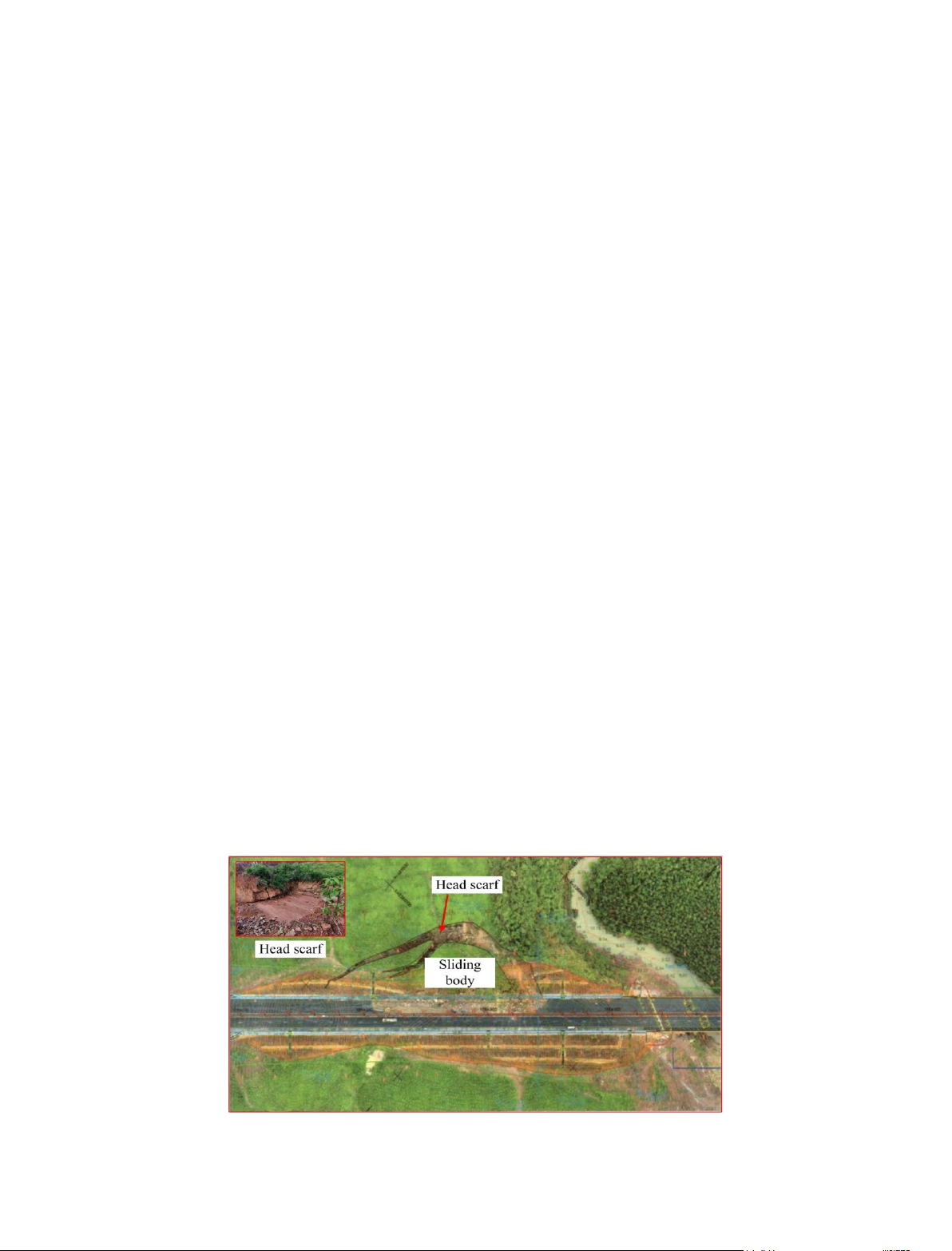
The sliding area is 7000 m2, 200 m wide,
about 70 m long, and 16 m high. The volume of
sliding rock is estimated at 70000 m3 with a
sliding direction of 1500. The sliding area locates
at the siltstone and shale of the Ha Coi formation.
The stratigraphy mainly consists of highly to
moderately weathered and interbedded siltstone
and shale. The sliding surface has occurred in
moderately weathered shale, which has low
mechanical properties, as shown in the left top
corner in Figure 1. It seems that the weak bedding
plane has played an important role in causing the
rock slide in addition to other unfavourable
factors such as rainfall and human activity, etc.
2.2. Geological Setting
Figure 1. Overview of the rock slide.
Nghia Tuan Do et al./Journal of Mining and Earth Sciences 66 (2), 39 - 49 41
2.2.1. Topographical condition
The rock slope is located at the hilly terrain.
With respect to topographical condition, the slope
surface is originally convex with the elevation of
31.0÷72.0 m. The original hill slope is southeast
facing whereas the expressway’s direction is from
southwest to northeast. The slide direction is
nearly the same as the slope aspect outward. The
height of the cut slope is 16 m. As shown in Figure
2, the arc-shaped sliding has moved from the
original slope toward the expressway and the
maximum distance of detachment is 25 m. The
main head scarp is about 11 m high. The sliding
angle of the failure surface is from 12÷150, which
matches that of the bedding plane.
2.2.2. Lithology and geological structure
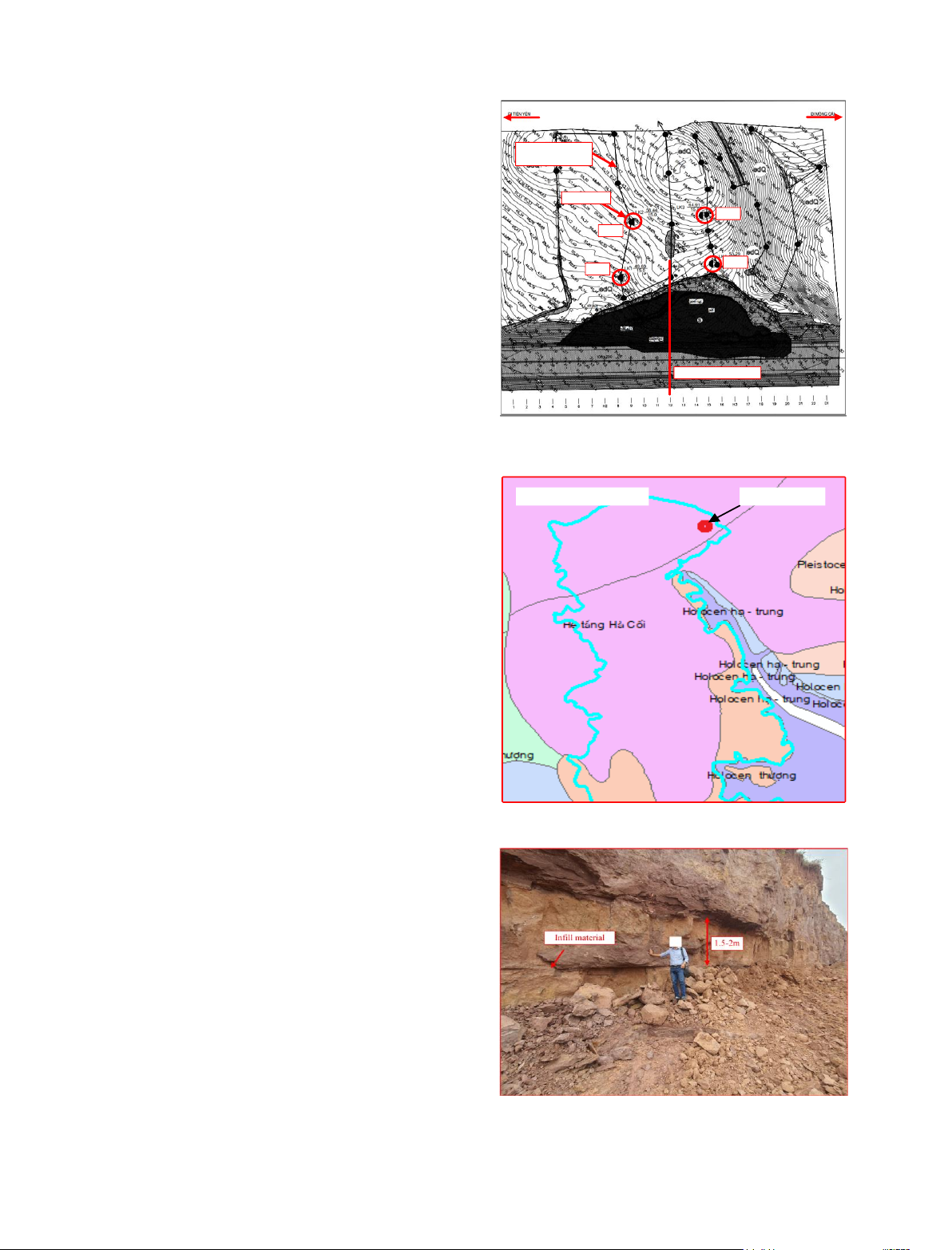
Based on the Vietnam geological map (Figure
3), the rock slide is located in the upper part of the
Ha Coi formation (J1-2hc2), which is Jurassic red
continental sedimentary rocks. Also, they are
thick bedded, fine-grained sandstones
interbedded with medium-bedded chocolate pink
siltstones or thin-bedded shales. In general, the
sedimentary rocks are medium to thick bedded
with the thickness of rock layer from 0.3÷0.8 m. At
some locations, their thickness is even greater, as
shown in Figure 4. Tectonic movements have
taken place in the area of the rocks and made
them folded and slightly foliated. The rock
bedding dip is the southeast and the dip direction
is from 140÷1800 whereas the dip angle is from
10÷120. The rocks are moderately jointed in
general, at which the bedding planes and fractures
are random and not consistent.
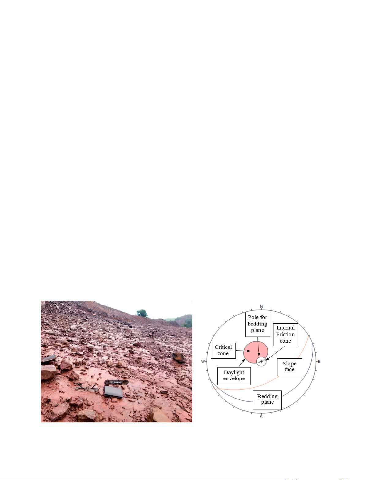
Bedding joints are the major structural
features of the rock layer in the site with a
dominant orientation (Figure 4). As shown in
Figure 5, a thin film of calcite infill could be
observed at most of bedding joints, which is
attributed to the existence of groundwater in
joints causing calcite to precipitate. This infill
material with low shear strength will contribute
to the sliding of the rock slope. In addition, strong
rock layers, including siltstone, fine quartz
sandstone, are sandwiched by highly weathered
shale layers, which are easily softened under
saturated conditions. These thin shale layers
could become potential sliding surfaces of the
Cross section 12-12
Bore hole
Site investigation
path
Tien Yen Mong Cai
LK2
LK1LK4
LK3
Figure 2. Topographic map and borehole layout of
the rock sliding area Do et al. (2024).
Ha Coi formation Study area
Figure 3. Geological map of the study area.
Figure 4. Interbedded siltstone at the head scarp of
slope failure Do et al. (2024).
42 Nghia Tuan Do et al./Journal of Mining and Earth Sciences 66 (2), 39 - 49
slope (Figure 5). Based on the rock mass quality,
two bedrock layers can be characterized,
including moderately weathered horizon and
slightly weathered horizon ones. There is a
residual and colluvium soil layer, which overlays
the bedrock. Section 2.3 will describe the
characteristics of soil and rock layers in detail.
2.2.3. Kinematic analysis of slope
The rock slide can be classified as a planar
sliding type due to its characteristics as shown in
Figs. 1, 2, 4, and 5. The study by Hoek and Bray
(1981) has addressed the kinematic conditions
for a plane mode of failure when the strike
difference between the slope face and the
potential failure surface is almost parallel (±200).
Also, the lateral surfaces on both sides of the
sliding block would not provide any resistance
against the sliding. A plane failure may occur
when a discontinuity dips in a similar direction to
the slope surface, which is smaller than the slope
angle but greater than the friction angle along the
failure plane. There is no side effect to the stability
of the slope because the slope surface is convex.
The stereographic projection slope section with
the dominant bedding planes and the cut slope
face is shown in Figure 6. Potential plane failure
can be observed in this figure. If it is assumed that
the shear strength of the bedding joint is
contributed from the friction angle only, the
planar failure will take place once the friction
angle is lower than the dip angle of bedding
planes, i.e., from 12÷150
2.3. Soil And Rock Properties
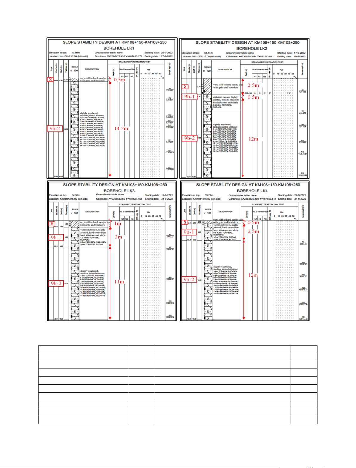
Four bore holes have been performed in the
site as marked by LK1, LK2, LK3, and LK4 in
Figure 7 to determine soil stratigraphy and
characteristics of soil and rock layers. It is
observed that the stratigraphy consists of three
soil and rock layers. The soil layer 8 is located at
the top of the slope surface, which is very stiff to
hard sandy clay with grits and boulders. This layer
is from 0.5÷2.5 m thick. Beneath this layer is the
moderately weathered layer (layer 9b-1), which is
violetish brown, highly jointed, hard to medium
hard siltstone, and shale with poor quality indexes
TCR = 25÷83% and RQD = 0÷36%. This layer is
from 0.5÷3.0 m thick. The slightly weathered,
medium-jointed siltstone (layer 9b-2) is located at
the bottom of the stratigraphy. This layer has
rather good quality indexes with TCR = 60÷97%
and RQD = 25÷92%. The thickness of this layer is
greater than the borehole depth. In general, this
layer can be characterized as good to very good
rock. It is noted that this is an inhomogeneous
layer inserted with the thin layers of soft rock or
highly fractured rock corresponding to fair to
poor rock.
Tables 1 and 2 summarize the results of
laboratory tests for the soil and rock layers,
respectively. In order to perform stability
analysis, the cohesion and friction angles at both
natural and saturated states were determined for
the soil layer 8.
Figure 5. Smooth sliding surface of the rock layer.
Figure 6. Kinematic analysis of the slope
stability Do et al. (2024).
Nghia Tuan Do et al./Journal of Mining and Earth Sciences 66 (2), 39 - 49 43
Table 1. Soil properties from laboratory tests.
Properties
Layer 8
Properties
Layer 8
Type of soil (USCS)
CL
Degree of saturation, Sr (%)
91.22
Water content, w (%)
22.1
Liquid limit, LL (%)
38.0
Natural unit weight, (kN/m3)
20.0
Plastic limit, PL (%)
22.0
Dry unit weight, d (kN/m3)
16.4
Plasticity index (%), PI
16.0
Saturated unit weight, sat (kN/m3)
20.4
Coefficient of compressibility, av,1-2 (1/kPa)
0.017
Specific gravity, Gs
2.72
Effective cohesion at natural state, c (kPa)
25.5
Porosity, n (%)
39.72
Effective internal friction angle at natural state, (0)
23005’
Void ratio, e
0.659
Effective cohesion at saturated state, c (kPa)
17.7
Effective internal friction angle at saturated state, (0)
18058’
Figure 7. Soil profiles at different boreholes.


![Đề cương bài giảng Bản đồ đại cương [mới nhất]](https://cdn.tailieu.vn/images/document/thumbnail/2026/20260323/hoatudang2026/135x160/81191774414215.jpg)
![Tài liệu giảng dạy Bản đồ và Hệ thống thông tin địa lý [chuẩn nhất]](https://cdn.tailieu.vn/images/document/thumbnail/2026/20260323/hoatudang2026/135x160/61501774414218.jpg)


