2 Journal of Mining and Earth Sciences, Vol 66, Issue 2 (2025) 2 - 14
Optimizing machine learning models for enhanced
forest fire susceptibility mapping in Gia Lai province
Hung Van Le 1,*, Duc Anh Hoang 2, Giang Truong Tran 2
1 Thuyloi University, Hanoi, Vietnam
2 Hanoi University of Mining and Geology, Hanoi Vietnam
ARTICLE INFO
ABSTRACT
Article history:
Received 24th Oct. 2024
Revised 14th Jan. 2025
Accepted 29th Jan. 2025
Forest fires pose significant risks to ecosystems, biodiversity, human health,
and the economy, with escalating global impacts. In Vietnam, particularly
during the dry season, the rising threat of forest fires necessitates accurate
predictive models for effective prevention and management. This study
advances forest fire susceptibility mapping in Gia Lai province by leveraging
optimized machine learning models. We evaluated five models - Deep Neural
Networks (DNN), Random Forest (RF), Gradient Boosting (GB), Logistic
Regression (LR), and Support Vector Machines (SVM) - using a dataset of
2,827 fire incidents (2007÷2021), an equal number of non-fire points, and 12
influencing factors: slope, aspect, elevation, curvature, land use, NDVI
(Normalized Difference Vegetation Index), NDWI (Normalized Difference
Water Index), NDMI (Normalized Difference Moisture Index), temperature,
wind speed, relative humidity, and rainfall. Among the models, RF
outperformed others and was further optimized using Genetic Algorithm
(GA), Particle Swarm Optimization (PSO), and Bayesian Optimization (BO).
The Acc-GA-Opt-RF model (Accuracy-Optimized Random Forest using GA)
achieved the best performance, with 84.4% accuracy, an AUC (Area Under
the ROC Curve) of 0.9083, PPV (Positive Predictive Value) of 88.2%, NPV
(Negative Predictive Value) of 81.2%, sensitivity of 79.3%, specificity of
89.4%, F-score of 0.8354, and Kappa of 0.687, demonstrating significant
improvements over the unoptimized RF model. Factor importance analysis,
employing Average Impurity Decrease (AID) and Permutation Feature
Importance (PFI), identified NDVI and NDWI as key predictors, highlighting
the critical role of vegetation indices in forest fire susceptibility. The optimized
RF model was utilized to generate a forest fire susceptibility map
categorizing the region into six risk levels, providing actionable insights for
targeted fire prevention and management in Gia Lai province.
Copyright © 2025 Hanoi University of Mining and Geology. All rights reserved.
Keywords:
Forest fire,
Gia Lai,
Machine learning,
Modeling,
Optimization.
_____________________
*Corresponding author
E - mail: hungvle@tlu.edu.vn
DOI: 10.46326/JMES.2025.66(2).02

Hung Van Le et al./Journal of Mining and Earth Sciences 66 (2), 2 - 14 3
1. Introduction
Forest fires are highly destructive natural
disasters that cause ecosystem damage,
biodiversity loss, forest degradation, and
greenhouse gas emissions, posing significant
threats to human health and the economy
(Anandaram et al., 2023). In Vietnam, particularly
during dry seasons, these fires are often triggered
by extreme weather and human activities such as
slash-and-burn agriculture, leading to the loss of
over 7,500 ha of forest in the past five years
(VietNamNet Global, 2022). The rising frequency
and severity of forest fires, intensified by climate
change, highlight the urgent need for accurate
predictive models to reduce environmental and
economic impacts and protect human lives
(Flannigan et al., 2009).
Machine learning (ML) models are crucial for
predicting forest fire susceptibility, utilizing
extensive datasets on weather, topography,
vegetation, and historical fire data (Abid, 2021;
Bui et al., 2018; Le et al., 2020). High-performance
models like DNN, RF, and GB have proven
effective in forest fire prediction (Le et al., 2021;
Sathishkumar et al., 2023). Ensemble models such
as RF and GB excel due to their ability to manage
complex data and enhance prediction accuracy
(Jain et al., 2020; Sarkar et al., 2024).
Optimizing hyperparameters is essential for
enhancing ML model performance, especially in
forest fire prediction (Al-Shabeeb et al., 2023; Bui
et al., 2017; Islam et al., 2023). This study focuses
on optimizing ML models to improve forest fire
susceptibility mapping in Gia Lai province,
Vietnam. We evaluated DNN, RF, GB, and
benchmark models like LR and SVM. The RF
model performed best and was further optimized
using GA, PSO, and BO. The Acc-GA-Opt-RF model
achieved superior performance with 84.4%
accuracy, an AUC of 0.9083, and marked
improvements in PPV, NPV, sensitivity, and
specificity over the unoptimized RF model.
Feature importance was assessed using AID
and PFI, with NDVI and NDWI identified as the
most influential predictors of forest fire
susceptibility. NDVI was the top factor, with
importance values of 0.221 (AID) and 0.256 (PFI),
highlighting the critical role of vegetation indices
in fire risk prediction.
The optimized RF model was used to
generate a forest fire susceptibility map for Gia
Lai, categorizing the region into six risk levels,
providing essential insights for targeted fire
prevention and management. The study
demonstrates the effectiveness of optimized ML
models in enhancing predictive accuracy and
supporting fire risk mitigation in high-risk areas.
The paper is structured as follows: Section 2
reviews the algorithms and optimization
methods. Section 3 describes the study area and
GIS database. Section 4 outlines the modeling
methodology. Section 5 presents results and
discusses model performance and factor
significance. Section 6 concludes with key
findings.
2. Background of the Algorithms Used
2.1. Benchmark Models
Benchmark models play a crucial role in
developing and refining machine learning models
by providing a baseline for comparison, helping to
determine if new models outperform existing
methods. In this study, LR, SVM, and DNN are used
as benchmark models. LR offers a straightforward
baseline for binary classifications, including forest
fire susceptibility (Chang et al., 2013). SVM is
effective for high-dimensional data, utilizing
kernel functions to adapt to various data
structures (Singh et al., 2021). DNN excels in
capturing complex patterns through multiple
hidden layers, addressing challenges beyond
simpler models (Le et al., 2021).
2.2. Ensemble Learning
Ensemble learning models combine simpler
models into a composite, providing higher
accuracy and reducing variance and bias, thereby
minimizing overfitting (Russell & Norvig, 2021).
Their enhanced performance makes them
preferred for assessing forest fire susceptibility
(Hoang et al., 2023; Singh & Jeganathan, 2024).
2.2.1. Random Forest
RF combines multiple decision trees to create
a more accurate and robust model, reducing
overfitting and enhancing prediction accuracy,
making it effective for large, complex datasets
(Breiman, 2001). Its versatility and reliability

4 Hung Van Le et al./Journal of Mining and Earth Sciences 66 (2), 2 - 14
make RF a preferred choice for predicting forest
fires (Gao et al., 2023; Singh & Jeganathan, 2024).
RF’s capability to assess feature importance also
aids in improving prediction accuracy.
Optimizing key RF hyperparameters is
crucial for maximizing classification performance,
particularly in forest fire susceptibility prediction
(Bar et al., 2023). Key hyperparameters include
(Breiman, 2001) : (1) n_estimators, which
determines the number of trees and affects
accuracy and overfitting risk; (2) max_depth,
which controls tree complexity; (3) max_features,
impacting model generalization; (4)
min_samples_split, managing the minimum
samples required to split nodes to prevent
overfitting; and (5) min_samples_leaf, reducing
overfitting by setting the minimum samples at leaf
nodes. The careful tuning of these parameters
enhances accuracy and model generalization on
new data.
2.2.2. Gradient Boosting
Boosting combines multiple weak learners
sequentially, creating a strong model where each
step corrects the previous errors. Gradient
Boosting (GB) refines models by minimizing
errors through gradient optimization. Key GB
algorithms include AdaBoost, XGBoost, and
CatBoost: AdaBoost enhances weak models'
accuracy, XGBoost offers high performance and
scalability, and CatBoost excels with categorical
data (Russell & Norvig, 2021). GB algorithms are
highly effective in classification tasks, including
forest fire prediction (Koh, 2023).
2.3. Optimization Algorithms
Common optimization algorithms include
BO, GA, and PSO. BO improves search efficiency by
using past trial data to predict future outcomes
(Islam et al., 2023). GA, inspired by evolutionary
processes like selection, crossover, and mutation,
identifies optimal hyperparameters (Al-Shabeeb
et al., 2023). PSO, modeled on animal behavior,
uses particles representing solutions that explore
the search space through shared and individual
experiences (Bui et al., 2017).
3. The Study Area and GIS Database
3.1. The Study Area
Gia Lai province (Figure 1) is situated in
south-central Vietnam, covering 15,510 km². Its
topography varies from 1,748 m at Kon Ka Kinh
mountain in K’Bang district to 80 m in Krongpa
district. In 2022, the province had a population of
1.591 million, with a density of 103 people/km².
The economy relies heavily on agriculture,
forestry, and fishing, contributing 22.2% to the
GDP, with industry and construction at 18.96%,
and retail and services at 58.84% (General
Statistics Office, 2023).
Agricultural and forested lands make up
90.14% of Gia Lai’s area, with residential areas
comprising 1.11%. The province has 648,300 ha
of forest, including 478,800 ha of natural forest
and 169,500 ha of planted forest (General
Statistics Office, 2023). Frequent forest fires over
the last decade have put 216,153 ha at high
susceptibility, especially in planted, deciduous,
and mixed bamboo forests (Nguyen, 2021).
Gia Lai experiences a tropical monsoon
highland climate with high humidity and
significant rainfall (Van et al., 2014). The rainy
season spans from May to October, while the dry
season runs from November to April. The average
annual temperature ranges from 22 to 25°C, with
annual rainfall between 2100 and 2200 mm (Le et
al., 2021).
3.2. Forest Fire Inventory
This study utilizes a database of 2,827 forest
fire incidents recorded from 2007 to 2021 (Figure
1c), originally compiled by Le et al. (2020) and
Figure 1. (a) and (b) Location of Gia Lai province,
(c) Gia Lai province and forest fire locations map.
Hung Van Le et al./Journal of Mining and Earth Sciences 66 (2), 2 - 14 5
subsequently updated with recent data. Fire
locations were sourced from the Forest
Protection Department's database
(http://www.kiemlam.org.vn). The 2020-2021
dry season saw increased fire activity, with ten
major fires affecting over 177 ha (Nguyen, 2021).
Statistical analysis indicates that around 80% of
fires occurred during the dry season, mainly
between January and April. Severe fires were
particularly noted in 2010, 2013, 2015, and 2016,
largely driven by El Niño–Southern Oscillation
events, causing droughts and a 12% reduction in
rainfall (Sutton et al., 2019). In contrast, La Niña
years, like 2011, experienced minimal fire activity
(Le et al., 2021).
3.3. Influencing Factors
Forest fires result from ignition sources and
various factors, including topography, vegetation,
climate, and human activities (Cary et al., 2009).
Identifying these influencing factors is essential
for modeling forest fire susceptibility. This section
outlines the factors considered in this study, with
detailed descriptions available in (Le et al., 2021).
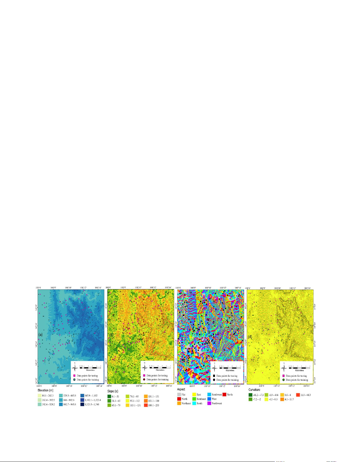
3.3.1. Topographical factors
Topography significantly influences forest
fires through indirect and direct effects. Terrain
variations create microclimates that affect
temperature, vegetation cover, and tree species
distribution, indirectly impacting fire occurrence
and spread (Mermoz et al., 2005). Key factors like
slope, aspect, elevation, and curvature directly
influence fire spread and flammability. Slopes
accelerate fire spread compared to flat areas
(Dupuy & Maréchal, 2011), aspect affects solar
radiation and vegetation moisture (Bennie et al.,
2008), higher elevations with cooler
temperatures and more precipitation reduce fire
risk (Chen et al., 2018), and curvature alters soil
conditions, affecting ignition probability (Hilton et
al., 2016).. This study utilized a 30 m-resolution
DEM of Gia Lai province to extract and analyze
these factors (Figure 2) to evaluate their impact
on forest fire behavior.
3.3.2. Human-Induced and Vegetation Factors
Human activities are a primary driver of
forest fires globally, as population growth
increases pressure on ecosystems, leading to
deforestation and intensified land use, which
elevate fire risks, especially in certain tree species
(Viedma et al., 2017). Therefore, land use is a
critical factor in forest fire prediction. In this
study, we developed a land use map (Figure 3)
with eleven categories based on district-level land
use plans from Gia Lai province, provided by the
People's Committee at a 1:50,000 scale.
For vegetation factors, we used the
Normalized Difference Vegetation Index (NDVI)
to assess vegetation health and fire fuel potential
(Carlson & Ripley, 1997). Additionally, the
Normalized Difference Water Index (NDWI) and
Normalized Difference Moisture Index (NDMI)
Figure 2. (a) Elevation map, (b) Slope map, (c) Aspect map, and (d) Curvature map.
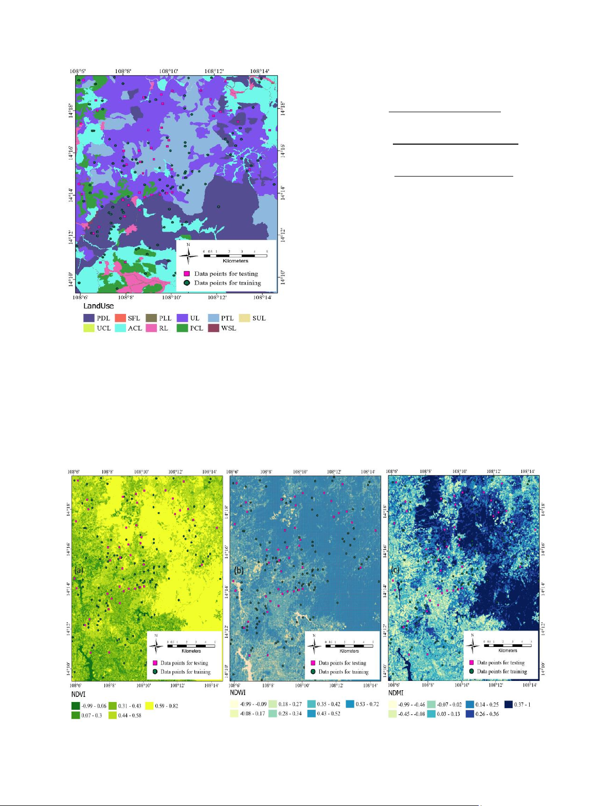
6 Hung Van Le et al./Journal of Mining and Earth Sciences 66 (2), 2 - 14
were used to evaluate vegetation water content
and fuel moisture. These indices are crucial in
predicting fire behavior due to their influence on
fuel conditions. NDVI, NDWI, and NDMI were
derived from 2021 Landsat-8 OLI satellite images
with a 30 m resolution from the USGS
EarthExplorer portal, following methods by
(Tucker, 1979), (McFeeters, 1996), and (Wilson &
Sader, 2002):
𝑁𝐷𝑉𝐼 = 𝑁𝐼𝑅 𝑏𝑎𝑛𝑑 − 𝑅𝑒𝑑 𝑏𝑎𝑛𝑑
𝑁𝐼𝑅 𝑏𝑎𝑛𝑑 + 𝑅𝑒𝑑 𝑏𝑎𝑛𝑑
𝑁𝐷𝑊𝐼 = 𝐺𝑟𝑒𝑒𝑛 𝑏𝑎𝑛𝑑 − 𝑁𝐼𝑅 𝑏𝑎𝑛𝑑
𝐺𝑟𝑒𝑒𝑛 𝑏𝑎𝑛𝑑 + 𝑁𝐼𝑅 𝑏𝑎𝑛𝑑
𝑁𝐷𝑀𝐼 = 𝑁𝐼𝑅 𝑏𝑎𝑛𝑑 − 𝑆𝑊𝐼𝑅 𝑏𝑎𝑛𝑑
𝑁𝐼𝑅 𝑏𝑎𝑛𝑑 + 𝑆𝑊𝐼𝑅 𝑏𝑎𝑛𝑑
Where NIR and SWIR represent the Near-
Infrared and Short-Wave Infrared spectral bands,
respectively. The maps of NDVI, NDWI, and NDMI
are presented in Figure 4.
3.3.3. Meteorological Factors
Research has shown a strong link between
climate change and forest fire patterns (Lacroix et
al., 2020), highlighting the need to include
climate-related factors in our analysis.
We selected four key climatic variables:
temperature, wind speed, relative humidity, and
rainfall (Figure 5), with data from 2007÷2021
sourced from https://www.ncdc.noaa.gov/.
Temperature impacts soil moisture and directly
influences plant combustion (Pourtaghi et al.,
2016), and rising temperatures reduce vegetation
moisture, elevating fire risk (Gillett et al., 2004).
Wind speed affects fire spread by altering fuel
moisture and supplying oxygen (Alexandridis et
Figure 3. Land use map.
Figure 4. (a) NDVI map, (b) NDWI map, and (c) NDMI map.


![Tài liệu Vi sinh vật môi trường [Mới nhất]](https://cdn.tailieu.vn/images/document/thumbnail/2025/20251123/ngkimxuyen/135x160/21891763953413.jpg)
![Sổ tay truyền thông Phân loại chất thải rắn sinh hoạt trên địa bàn tỉnh Quảng Nam [Chuẩn nhất]](https://cdn.tailieu.vn/images/document/thumbnail/2025/20251114/kimphuong1001/135x160/1701763094001.jpg)


![Quản lý chất thải nguy hại: Sổ tay Môi trường [Chuẩn nhất]](https://cdn.tailieu.vn/images/document/thumbnail/2025/20251029/kimphuong1001/135x160/9011761720170.jpg)