
Vietnam Journal
of Agricultural
Sciences
ISSN 2588-1299
VJAS 2020; 3(4): 817-830
https://doi.org/10.31817/vjas.2020.3.4.05
https://vjas.vnua.edu.vn/
817
Received: March 11, 2020
Accepted: December 18, 2020
Correspondence to
nguyenhuuthanh@vnua.edu.vn;
hlhuong@vnua.edu.vn
Assessment of Land Resources Potentials
for Orientation of Agriculture Land Use in
Ham Thuan Bac district, Binh Thuan
province
Nguyen Huu Thanh1, Hoang Le Huong2, Ngo Thanh Son1,
Luyen Huu Cu1, Nguyen Duc Hung1, Nguyen Tho Hoang1 &
Nguyen Van Thao1
1Faulty of Land Management, Vietnam National University of Agriculture, Gia Lam, Hanoi
131000, Vietnam
2Consulting Center of Technological Sciences for Natural Resources and Environment,
Vietnam National University of Agriculture, Gia Lam, Hanoi 131000, Vietnam
Abstract
Land resources potential assessment is a valuable method for
orienting land use planning in the world as well as in Vietnam. This
study aimed to (1) assess land suitability and (2) orient the effective
use of agricultural land in the study area. Results indicated that Ham
Thuan Bac had 107 land mapping units (LMUs) with 11 main land-
use types (LUTs) such as rice, cassava, vegetables, dragon fruit, and
other trees. Agricultural land with high (S1) and moderate suitability
(S2) for most LUTs was small; however, marginal (S3) and not
suitability (N) lands were quite large. Results of land suitability
evaluation on current land use showed that land area of annual crops
was mainly found at the S3 suitability level, specifically for the rice
area, 67.75% was marginally suitable and 23.29% of the area was
unsuitable; In terms of perennial trees, except for dragon fruits which
were mainly cultivated at the S2 suitability level (78.28%), the others
such as cashew and other fruit trees were S3 and N levels. Based on
land suitability classification, for mainstay LUTs, we proposed to
keep 8550.0ha with S1, S2, and a part of S3 area to be irrigated for
cultivating rice; 9071.7ha of dragon fruit land including 694.67ha of
S1 and 8377.03ha of S2 land; only cultivate annual crops, fruit trees
and grazing grass on the land with suitable levels from S1 to S3 of
the current status; and the remaining areas of S3 and N levels for rice
and areas of S2, S3, or N levels for dragon fruit would be converted
to lands for annual crops, fruit trees, or grass for livestock.
Keywords
Agricultural land use, land resources potentials, land suitability, Ham
Thuan Bac district
Introduction
Assessment of land resource potentials is a fundamental step in

Assessment of land resources potentials for orientation of agriculture land use in Ham Thuan Bac district, Binh Thuan
818
Vietnam Journal of Agricultural Sciences
the process of land use planning (LUP) when
land resources are limited (Bandyopadhyay et
al., 2009). The rapid population growth, as well
as human activities, has created pressure on
agricultural land. Intensified farming activities
without proper land management practices lead
to the degradation of land (Abdelrahman et al.,
2016). Land evaluation approach allows for
identifying fundamental limiting factors for
agricultural production, provides information in
terms of constraints and opportunities for the
utilization of land, and then guides decisions
based on the optimal prerequisite for land use
planning and development (Motuma et al., 2016;
Truong et al., 2014; Pham Quang Vinh & Pham
Thi Thanh Huong, 2012). Thus, land evaluation
is implemented before recognizing the need for
some changes in land use such as agricultural
development or forestry plantation schemes.
Land suitability assessment plays an
important role in agricultural development and
future planning (Belal et al., 2014). This has been
implemented to help decision-makers and
agriculture development planners determine the
optimal use of the land. Assessing land suitability
for various crops is necessary to choose the right
crop and variety for the area based on matching
the suitability of the area with the crop. Various
methods of land evaluation have been developed
throughout the years (FAO, 1976; Sys, 1985).
The Food and Agricultural Organization (FAO,
1976) recommended an approach for land
suitability evaluation for crops in terms of
suitability ratings ranging from highly suitable to
not suitable based on climatic and terrain data
and soil properties. Sys (1985) proposed a range
of capability indexes to denote soil limitations
for crop production. A land suitability
assessment could be viewed from three different
perspectives: (i) productivity; (ii) workability;
and (iii) sustained use of the land (Baja et al.,
2001). With advances in information and
communication technology, land evaluation
through map analysis techniques based on the
theoretical framework from FAO has been
completed using a geographical information
system (GIS) to analyze land capability to sustain
a defined land use.
Ham Thuan Bac, a mountainous district of
Binh Thuan province, has an agricultural land
area of approximately 124 thousand hectares.
Land resources are playing an important role in
the economic development of the district.
However, a serious constraint in this district is
the lack of irrigation water during the dry season.
Drought is one of the major factors limiting crop
production in the area. Therefore, to maximize
the effectiveness of the land resources, it is
necessary to assess land suitability for
agricultural production in Ham Thuan Bac
district (Ngo Thanh Son et al., 2018; Hoang Le
Huong et al., 2018). In drought-affected
conditions, irrigation restricted areas are not
suitable for crops that require water such as rice.
Hence, it is an important step for the orientation
of agricultural land use planning in the future.
The objectives of the study were: (1) to
assess land suitability; and (2) to orient an
effective use of agricultural land in Ham Thuan
Bac district. The results of the study could help
to estimate the potential conversion of
agricultural land and to recommend an effective
agricultural land use system.
Study Area
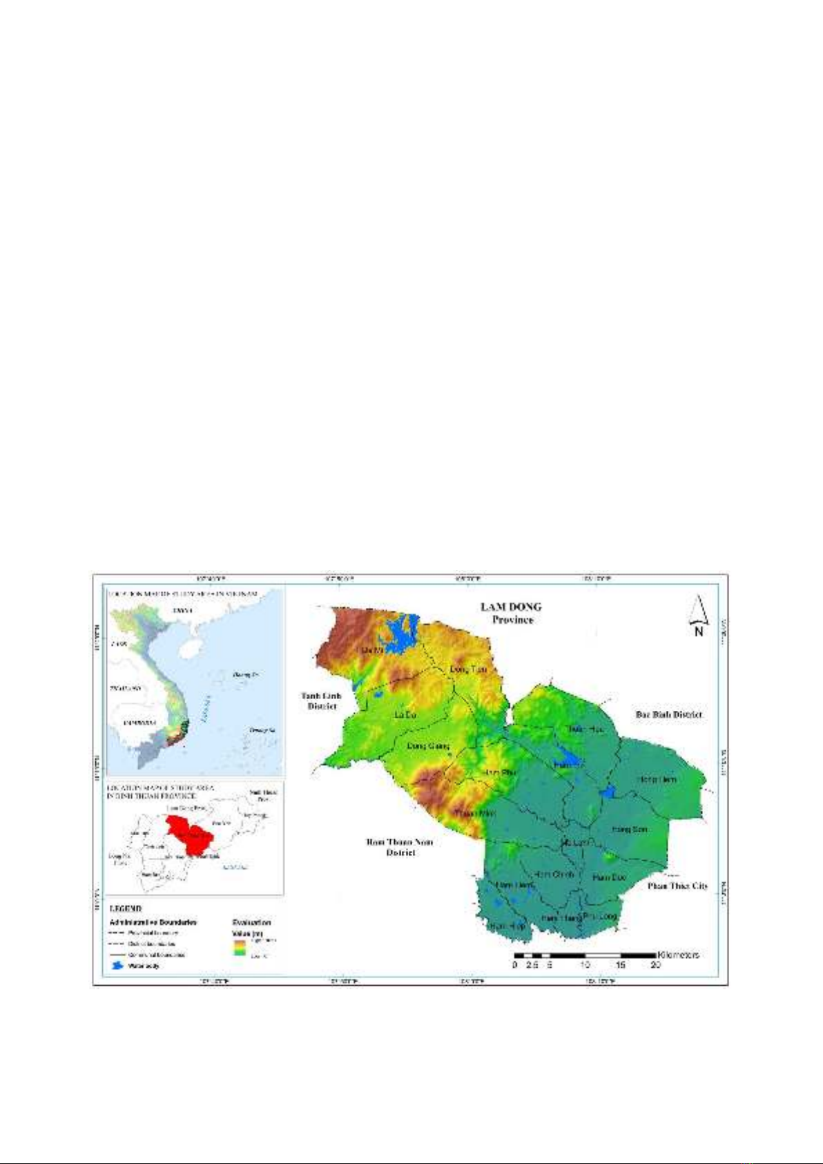
Ham Thuan Bac district is located in Binh
Thuan province, Southern Central Coast of
Vietnam (Figure 1). The natural area is
1347.21km2 (Figure 1) with a population of
173,253 people (2017). In this area, the
topography is quite diversified including semi-
mountainous terrain, alluvial plain, and coastal
sand. The climate, characterized by the tropical
monsoon region, is divided into two seasons,
namely the rainy season from May to October
and the dry season from November to April. The
average temperature is approximately 26oC to
28oC and the annual total precipitation varies
from 1070mm (delta areas) to 1995mm (high
mountains). However, precipitation is highly
variable and unevenly distributed. Due to
reduced rainfall in the dry season (11% of the
total annual rainfall), the dry season often causes
serious water shortages for food production and
people's daily needs. According to reports from
the Department of Agriculture and Rural
Nguyen Huu Thanh et al. (2020)
https://vjas.vnua.edu.vn/
819
Development at Ham Thuan Bac district (2017),
agricultural activities in many areas still depend
on rain.
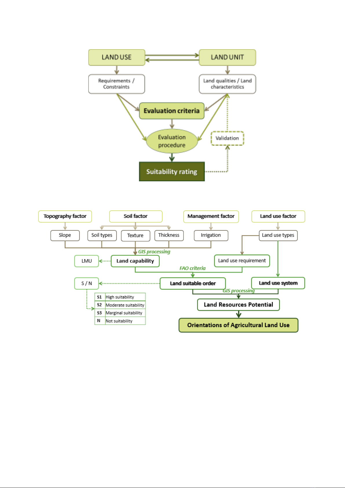
Methodology
The assessment of land quality for a specific
type of land use is based on land use
requirements and constraints. Such requirements
and constraints are then used as the basis for
establishing what is termed ‘evaluation criteria’
(Figure 2).
Regarding these ‘evaluation criteria’, a set of
algorithms is then employed to match the
existing quality of land and the requirements of
that particular type of land use.
The matching procedure (FAO, 1976 and
after) then establishes a ranking of the potentials
of land for a given purpose. The final result of the
land evaluation is a map that portrays the
divisions of the area of interest into suitability
classes or land unit indices for nominated land
use. The first is produced from an approach
called a categorical system and the second from
a continuous method of land suitability
evaluation.
There are at least two important groups of
land attributes for land suitability analysis:
inherent qualities of soils and external
characteristics. In this study, soil attributes,
topographic elements, and management were
used to represent all groups.
Land-use factors are land use characteristics
in the study area such as land-use type or land
cover, thereby helping to define the land
attributes requirements appropriately. This study
focuses on agricultural land uses (annual and
perennial crops), identified through data
collection and field surveys.
The analytical procedure developed
consisted of the following steps (Figure 3):
Figure 1. Study site - Ham Thuan Bac district, Binh Thuan Province
Assessment of land resources potentials for orientation of agriculture land use in Ham Thuan Bac district, Binh Thuan
820
Vietnam Journal of Agricultural Sciences
Figure 1. Components of land suitability assessment
Source: Baja et al. (2001)
Figure 2. Methodological framework
Step 1. Determination of individual ratings
of land characteristics
Each of the land attributes within variables
in each group (i.e., soils, topography, and
management) was first independently examined
and rated from the collected data. The rating of
soil attributes was done based on the available
soil map which had ‘crisp’ boundaries, irrigation
areas identified from water resources data, while
that of topography was based on the DEM which
had continuous values.
Inherent qualities of soils
Soil types in Ham Thuan Bac included 8
groups with 17 soil types from G01 to G17
corresponding to the following specific soil types
(National Institute of Agricultural Planning and
Projection, 2003) (Table 1).

Nguyen Huu Thanh et al. (2020)
https://vjas.vnua.edu.vn/
821
Table 1. Soil types in Ham Thuan Bac district
Sym.
FAO soil classification
Vietnam soil classification
Area (ha)
G01
ARl
Luvic Arenosols
Cc
Sand dune soil
12,237.36
G02
ARg
Gleyic Arenosols
Cg
Glay Sandy
867.97
G03
SCh
Haplic Solonchaks
Mn
high saline soils
53.38
G04
FLe
Eutric Fluvisols
P
Alluvial soils without deposited
7,591.98
G05
FLb
Cambic Fluvisols
Pf
Alluvial soil with the variegated horizon
5,810.88
G06
FLu
Humic Fluvisols
Py
Stream alluvial soil
3,872.60
G07
AC
Acrisols
X
Gray soils
23,893.09
G08
ACg
Gleyic Acrisols
Xg
Glay gray soils
175.83
G09
FRx
Xanthic Ferralsols
Fa
Yellow-red soils on acid magma
30,950.05
G10
NTr
Rhodic Nitisols
Fk
Red-brown soil on basalt
13,717.42
G11
FRp
Plinthic Ferralsols
FL
Yellow-red soil changes due to rice cultivation
555.43
G12
FRx
Xanthic Ferralsols
Fp
Yellow-brown soil on ancient alluvial and sandstone
10,876.45
G13
FRx
Xanthic Ferralsols
Fs
Yellow red soil on clay rock
8,626.00
G14
NTh
Haplic Nitisols
Ft
Purple brown soil on basalt
2,205.56
G15
Fru
Humic Ferralsols
Ha
Red yellow humus on acid magma
2,226.21
G16
FLe
Eutric Fluvisols
D
Valley soil formed from accretion products
4,680.59
G17
LPq
Lithic Leptosols
E
Eroded soil is exposed to gravel
1,724.23
Water
W
Waterbody
4,386.19
Soil thickness varied from 0 to 30cm
(14,812.18ha), 30÷50cm (55.09ha), 50÷70cm
(17,249.08ha), 70÷100cm (49,668.55ha), and the
rest was greater than 100cm (4164.80ha).
Soil texture in Ham Thuan Bac district was
mainly light texture (sand, loamy sand, and
sandy loam) occupying 82,924.30ha (61.68%).
Heavy soil texture (clay loam, silty clay, and
clay) occupied 34,342.36ha (25.54%). The area
of medium soil texture (sandy clay loam, loam,
silty loam, silty, silty clay loam, and sandy clay)
was approximately 6,383.36 ha (4.75%).
External characteristics
The slope was divided into 6 levels with
approximately 50% of the natural land of Ham
Thuan Bac having a very gentle slope ranging
from 0 to 3o and 3 to 8o accounting for
54,043.51ha (40.20%) and 13,459.75ha
(10.01%), respectively. The semi-mountainous
area of the district has steep slope (>25o)
accounting for 31,598.28ha (23.50%). Gentle
slope (8÷15o), moderate slope (15÷20o), and
moderately steep slope (20÷25o) occupied
10,468.92ha; 4,032.87ha; and 11,667.48ha,
respectively.
The irrigation area was determined based on
the irrigation map of Binh Thuan province in
combination with the collected primary data.
There were 88,676.01ha (65.95% of agricultural
and forest land) which depended on rain (or
irrigation regime from rainwater), about
23,998.99ha (17.85%) that was actively
irrigated, and the remaining 12,595.81ha
(9.37%) that was a semi-active irrigation regime.
Step 2. Group ratings of land
characteristics
Land attributes within each group were then
combined using a ‘combination’ function. The
result was land capability or land mapping units
indicating areas with qualities that differed
sufficiently from other land units to affect their
suitability for different land uses (FAO). Land
Mapping Units (LMUs) of the Ham Thuan Bac
district were built in the area of agricultural land
and unused land by overlaying thematic maps
including soil types, slope, thickness, soil
texture, and irrigation regime (Figure 4). These

![Quy trình thao tác chuẩn canh tác xoài xuất khẩu: Tài liệu [mới nhất]](https://cdn.tailieu.vn/images/document/thumbnail/2026/20260515/baobinh_011/135x160/3451778818824.jpg)


%20--%3e%3cdefs%3e%3cstyle%3e%20.st0%20{%20fill:%20%23fff;%20}%20.st1%20{%20fill:%20%237800fa;%20}%20%3c/style%3e%3c/defs%3e%3cpath%20class='st1'%20d='M117.78,12.18H43.11c2.9,3.47,4.65,7.94,4.65,12.82,0,5.6-2.3,10.66-6.01,14.29h76.02l7.22-13.56-7.22-13.56Z'/%3e%3cg%3e%3cpath%20class='st0'%20d='M53.58,26.17h-.59v-1.46h.59v-4.96h2.83c1.78,0,2.67.94,2.67,2.82v5.76c0,1.87-.89,2.81-2.67,2.81h-2.83v-4.96ZM55.36,21.37v3.34h1.1v1.46h-1.1v3.34h1.01c.61,0,.91-.37.91-1.1v-5.93c0-.74-.3-1.1-.91-1.1h-1.01Z'/%3e%3cpath%20class='st0'%20d='M65.99,31.14h-1.8l-.31-2.07h-2.19l-.31,2.07h-1.64l1.82-11.39h2.62l1.82,11.39ZM65.28,18.04c-.25.46-.51.77-.75.94-.21.15-.47.22-.79.22-.26,0-.57-.07-.92-.22l-.38-.15c-.14-.05-.26-.07-.37-.07-.3,0-.53.18-.71.54l-.91-.68c.25-.46.51-.77.75-.94.21-.14.48-.21.79-.21.26,0,.57.07.92.21l.38.15c.14.05.26.07.37.07.3,0,.53-.18.71-.54l.91.68ZM61.91,27.52h1.73l-.87-5.76-.87,5.76Z'/%3e%3cpath%20class='st0'%20d='M74.53,26.89v1.52c0,1.91-.89,2.86-2.67,2.86s-2.67-.95-2.67-2.86v-5.93c0-1.91.89-2.86,2.67-2.86s2.67.95,2.67,2.86v1.11h-1.69v-1.22c0-.75-.31-1.12-.93-1.12s-.93.37-.93,1.12v6.15c0,.74.31,1.11.93,1.11s.93-.37.93-1.11v-1.63h1.69Z'/%3e%3cpath%20class='st0'%20d='M81.4,31.14h-1.8l-.31-2.07h-2.19l-.31,2.07h-1.64l1.82-11.39h2.62l1.82,11.39ZM75.9,19.2l1.52-1.91h1.71l1.51,1.91h-1.61l-.76-.95-.75.95h-1.61ZM77.32,27.52h1.73l-.87-5.76-.87,5.76ZM83.1,15.99l-1.76,1.91h-1.26l1.17-1.91h1.86Z'/%3e%3cpath%20class='st0'%20d='M84.86,19.75c1.78,0,2.67.94,2.67,2.82v1.48c0,1.87-.89,2.81-2.67,2.81h-.85v4.28h-1.79v-11.39h2.64ZM84.01,21.37v3.86h.85c.58,0,.87-.36.87-1.08v-1.71c0-.71-.29-1.07-.87-1.07h-.85Z'/%3e%3cpath%20class='st0'%20d='M93.51,19.75c1.78,0,2.67.94,2.67,2.82v1.48c0,1.87-.89,2.81-2.67,2.81h-.85v4.28h-1.79v-11.39h2.64ZM92.66,21.37v3.86h.85c.58,0,.87-.36.87-1.08v-1.71c0-.71-.29-1.07-.87-1.07h-.85Z'/%3e%3cpath%20class='st0'%20d='M98.8,31.14h-1.79v-11.39h1.79v4.88h2.03v-4.88h1.83v11.39h-1.83v-4.88h-2.03v4.88Z'/%3e%3cpath%20class='st0'%20d='M105.36,24.55h2.46v1.62h-2.46v3.34h3.09v1.63h-4.88v-11.39h4.88v1.63h-3.09v3.18ZM108.17,17.29l-1.76,1.91h-1.26l1.17-1.91h1.86Z'/%3e%3cpath%20class='st0'%20d='M112.2,19.75c1.78,0,2.67.94,2.67,2.82v1.48c0,1.87-.89,2.81-2.67,2.81h-.85v4.28h-1.79v-11.39h2.64ZM111.35,21.37v3.86h.85c.58,0,.87-.36.87-1.08v-1.71c0-.71-.29-1.07-.87-1.07h-.85Z'/%3e%3c/g%3e%3ccircle%20class='st1'%20cx='25'%20cy='25'%20r='20'/%3e%3cpath%20class='st0'%20d='M32.78,19.27c2.92,0,4.43,2.55,5.28,5.33l.71,2.17c.14.38-.33.75-.71.75h-5.61c.19-.33.24-.71.09-1.08l-.75-2.45c-.43-1.32-.99-2.64-1.79-3.77.75-.57,1.65-.94,2.78-.94h0ZM25,18.38c3.25,0,4.9,2.78,5.89,5.89l.76,2.45c.14.42-.33.8-.8.8h-11.69c-.42,0-.94-.38-.8-.8l.75-2.45c.99-3.11,2.64-5.89,5.89-5.89h0ZM25,11.35c1.74,0,3.11,1.37,3.11,3.11s-1.37,3.11-3.11,3.11-3.11-1.41-3.11-3.11,1.41-3.11,3.11-3.11h0ZM17.27,19.27c1.08,0,1.98.38,2.73.94-.8,1.13-1.37,2.45-1.74,3.77l-.8,2.45c-.14.38-.05.75.09,1.08h-5.56c-.42,0-.9-.38-.75-.75l.71-2.17c.9-2.78,2.41-5.33,5.33-5.33h0ZM17.27,12.91c1.51,0,2.78,1.27,2.78,2.83s-1.27,2.83-2.78,2.83-2.83-1.27-2.83-2.83,1.27-2.83,2.83-2.83h0ZM32.78,12.91c1.56,0,2.78,1.27,2.78,2.83s-1.23,2.83-2.78,2.83-2.83-1.27-2.83-2.83,1.27-2.83,2.83-2.83h0ZM27.07,28.56v.09c0,.57-.24,1.08-.61,1.46h0v.05c-.38.33-.9.57-1.46.57s-1.08-.24-1.46-.61h0c-.38-.38-.61-.9-.61-1.46v-.09h1.41v.09c0,.19.05.38.19.47v.05c.09.09.28.19.47.19s.38-.09.47-.19v-.05c.14-.09.24-.28.24-.47t-.05-.09h1.41ZM30.99,28.56v.09c0,1.65-.66,3.16-1.74,4.24-1.08,1.08-2.59,1.79-4.24,1.79s-3.16-.71-4.24-1.79l-.05-.05c-1.04-1.08-1.7-2.55-1.7-4.2v-.09h1.41v.09c0,1.27.47,2.4,1.27,3.25h.05c.85.85,1.98,1.37,3.25,1.37s2.4-.52,3.25-1.37c.85-.8,1.37-1.98,1.37-3.25v-.09h1.37ZM34.99,28.56v.09c0,2.78-1.13,5.28-2.92,7.07-1.79,1.79-4.29,2.92-7.07,2.92s-5.23-1.13-7.07-2.92c-1.79-1.79-2.92-4.29-2.92-7.07v-.09h1.41v.09c0,2.4.94,4.53,2.5,6.08,1.56,1.56,3.72,2.5,6.08,2.5s4.52-.94,6.08-2.5c1.56-1.56,2.5-3.68,2.5-6.08v-.09h1.41Z'/%3e%3c/svg%3e)