
Journal of Science and Technique - ISSN 1859-0209
171
APPLYING SEMI-SUPERVISED FUZZY C-MEANS
CLUSTERING ALGORITHM BASED ON COLLABORATIVE
CLUSTERING MODEL FOR LAND COVER CLASSIFICATION
FROM LANDSAT-7 IMAGERY
Dinh Sinh Mai1,*, Tuan Kiet Nguyen2, Chi Hieu Le2, Le Hung Trinh1
1Institute of Techniques for Special Engineering, Le Quy Don Technical University
2Military Topography Class Course 56, Le Quy Don Technical University
Abstract
The rapid development of artificial satellites has led to an explosion of remote sensing data
sources. Centralized storage of large data sources is becoming increasingly complex, and
decentralized storage solutions on distributed systems are increasingly gaining attention.
Traditional data mining techniques have become obsolete and are no longer suitable for
solving large, multidimensional, distributed data problems. These datasets, for some reasons
such as security, data transmission, privacy, etc., cannot be shared directly between
computers but can only share information about cluster structure. This article presents a semi-
supervised fuzzy c-means clustering algorithm based on the collaborative clustering model
(CSFCM) on distributed systems applied to the problem of land cover classification from
remote sensing data. The proposed model aims to solve the problem of land cover
classification where remote sensing data is decentralized and stored on a distributed system
of computers connected via the network. Experiments on four optical satellite image datasets
show that the proposed method provides significantly better results in both classification
quality and classification time compared to local clustering on individual datasets. This result
suggests that developing collaborative model-based data analysis algorithms can help solve
the problem of remote or distributed remote sensing image data analysis.
Keywords: Land cover classification; remote sensing imagery; distributed systems; collaborative clustering.
1. Introduction
With the rapid development of satellite science and technology, many remote
sensing data sources are collected and stored (big data) [1]. From multiple sources and
scales, complex structures and large volumes have led to an overload of centralized
storage systems. The current solution for storing large data sources is to divide them into
smaller datasets and store them in a distributed manner on a network of interconnected
computers [2]. Data processing, therefore, requires the development of algorithms and
* Corresponding author, email: maidinhsinh@lqdtu.edu.vn
DOI: 10.56651/lqdtu.jst.v7.n02.876.sce

Section on Special Construction Engineering - Vol. 07, No. 02 (Dec. 2024)
172
methods that enable decentralized data analysis on distributed systems [3]. This approach
can have a significant impact on data clustering, especially when the datasets are related.
If these datasets are related, clustering on one dataset can impact and influence clustering
on other datasets. However, these datasets cannot be clustered centrally for many reasons,
such as data privacy, security, transmission, etc. To address these challenges, it is
necessary to develop solutions that effectively handle distributed data issues. This
approach is important to overcome the limitations of centralized storage and ensure
efficient data clustering.
Collaborative data clustering is a tool to find structural similarities between data
samples located in multiple distinct regions based on the expansion of the objective
function and the fuzzy clustering method of the fuzzy c-means clustering algorithm [4].
Pedrycz introduced collaborative fuzzy clustering to find structures and similarities
between distinct datasets (distributed) [5]. There are two important characteristics of
collaborative fuzzy clustering. One is that detailed information in datasets cannot be
exchanged; only information about cluster structure can be exchanged. The second is to
consider whether clustering on this dataset affects clustering on other datasets.
Nowadays, parallel and distributed computing is one of the research directions
many scientists are interested in [6, 7]. Parallel and distributed computing is an important
tool in reducing the execution time, and it can be suitable for detecting objects on the
land's surface in real-time or near real-time from airborne and space-based platforms to
support immediate decision-making. This paper [6] reviews recent advances in anomaly
detection from hyperspectral remote sensing images and their implementation using
parallel and distributed systems. Wu et al. provide a survey of state-of-the-art methods
for processing remotely sensed big data and thoroughly study existing parallel
implementations on distributed systems [7]. Feng et al. presented a study on applying
distributed cloud computing architecture in hyperspectral remote sensing image
classification based on big data on the Spark platform [8].
Research by O'Reilly et al. shows that a distributed anomaly detection model in
many different network infrastructures can provide better results than a centralized
model [9]. Li et al. proposed to build a distributed file system to manage remote sensing
image data, taking ordinary files as the data model and TCP as the data transmission
model [10]. Experiments show that the proposed distributed file system has stable read
and write performance compared with existing systems. Wang et al. proposed an
innovative distributed collaborative method (DCM) for training remote sensing image
classification, showing that the proposed training method has better collaborative learning
ability than the centralized model [11]. Obtaining a comprehensive view of the entire

Journal of Science and Technique - ISSN 1859-0209
173
flooded area is an urgent issue in flood disasters. Xie et al. proposed a near-real-time
flood mapping system for automatic flood mapping with remote sensing image data and
related computational algorithms exploited in a collaborative environment [12]. Li et al.
designed and implemented a distributed parallel processing system for multi-source
remote sensing data based on a distributed cluster platform [13]. The system connects
several satellite data centers, serves several applications, and implements dynamic scaling
integration for high-performance quantitative remote sensing products.
The article proposes an algorithm for classifying land cover objects from remote
sensing images on a distributed system based on semi-supervised fuzzy c-means
clustering [14, 15] and a collaborative clustering model [4, 5]. This approach can
effectively solve decentralized data analysis problems, taking advantage of the power of
multiple computers on a distributed computing system. To experiment with the proposed
method, we use four optical remote-sensing image datasets stored on four computers
connected to each other via the network. The experimental results show that the proposed
method gives better results in both accuracy and running time compared to performing it
individually on each dataset.
The article is organized into four sections: Section 1 is the introduction overview
of the research content; Section 2 introduces some related knowledge; Section 3 presents
results and discussion; Section 4 gives the conclusion.
2. Materials and methodology
2.1. Materials
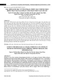
Landsat multi-temporal satellite images, after being collected from the USGS
database are pre-processed to remove spectral and geometric errors. Remote sensing data
used in the study are Landsat-7 TM satellite images taken from central Hanoi and
surrounding areas north of Hanoi [16], including image scenes on September 30, 2009
(Fig. 1). Satellite images are collected at a time not affected by weather. Experimental
area coordinates from 104° 39' 01.9986" E, 21° 38' 13.7121" N to 106° 27' 53.6258" E,
20° 53' 43.6835" N. Satellite image size 1916 × 831 corresponding to 1,592,196 pixels.
Landsat satellite image data is classified into six layers corresponding to six
corresponding land cover class types as follows:
Class 1: Rivers, lakes, ponds.
Class 2: Vacant land, roads.
Class 3: Field, grass.
Class 4: Sparse forest, low trees.

Section on Special Construction Engineering - Vol. 07, No. 02 (Dec. 2024)
174
Class 5: Perennial plants.
Class 6: Dense forest, jungle.
Fig. 1. Landsat image data in Hanoi area and surrounding areas on September 30, 2009.
2.2. Methodology
2.2.1. Semi-supervised fuzzy clustering
In data clustering problems, semi-supervised clustering is a hybrid technique between
supervised and unsupervised clustering. The advantage of this technique is that it uses a
very small amount of labeled data to improve the accuracy of the clustering results. This is
very suitable for datasets that cannot be applied to supervised learning techniques due to
difficulties in labelling or having very little labeled data. Many of these studies are semi-
supervised c-means fuzzy clustering algorithms (SFCM) [14]. The objective function of the
algorithm is supplemented with information about the labeled data.
The SFCM algorithm model is to optimize the following objective function:
2 * 2
11
( , , ) ( ( ) )
cn
m
m ik ik i i
ik
J U V X d v v
(1)

Journal of Science and Technique - ISSN 1859-0209
175
where
*
v
is the centroid computed from the labeled data,
[]
ik cxn
U
is a fuzzy MF,
12
( , ,..., )
c
V v v v
is a vector of (unknown) cluster centers,
{ , , 1,..., },
M
kk
X x x R k n
ik i k
d v x
. With the following constraints:
1
1; 0 1; 1; 1 ; 1
c
ik ik
i
m i c k n
(2)
The objective function
( , , )
m
J U V X
reaches the smallest value when and only if:
*
11
()
/
2
nn
mm
ki
i ik ik
kk
xv
v
(3)
1/( 1)
2 * 2
2 * 2
1
[ ( ) ]
1/ [ ( ) ]
m
c
ik i i
ik
jjk i i
d v v
d v v
(4)
Equation (3), (4) can be obtained based on the Lagrange multiplier theorem with
the constraints by objective function (2). SFCM algorithm will perform iterations
according to Eq. (3), (4) until the objective function
( , , )
m
J U V X
reaches the
minimum value.
2.2.2. Collaborative fuzzy clustering model on distributed systems
The idea of collaborative clustering is to locally cluster P subsets of data at
computers, the cluster centroids obtained after clustering are shared among computers to
calibrate the local cluster centroids. This process is repeated until all local cluster
centroids do not change significantly, then stop and give the final clustering result.
The collaborative fuzzy clustering problem has the objective function that needs to
be optimized as:
[ ] [ ]
2 2 2 2
[]
1 1 1 1 1
[ ] [ / ] ( [ / ])
N ii N ii
C P C
ii ik ik ik ik ik
k i jj k i
Q u ii d ii jj u u ii jj d
(5)
The above objective function consists of two parts, the first part is similar to the
objective function of the FCM algorithm [15]. The second part describes the collaboration
information between datasets on computers. In the above objective function,
ik
d
is the
distance between the kth pixel to the ith cluster center. The parameter
[ / ]ii jj
represents
the cooperation coefficient between datasets. The larger the value of
[ / ]ii jj
, the higher
the cooperation level, and the value
[ / ] 0ii jj
represents that there is no cooperation
between datasets ii and jj.
[]
ik
u ii
is the fuzzy partition matrix of object k into cluster i in


![Quy hoạch tổng thể Cà Mau: Tài liệu [mới nhất/chuẩn nhất]](https://cdn.tailieu.vn/images/document/thumbnail/2025/20250827/tghong1621@gmail.com/135x160/49401756278390.jpg)


![Bài giảng Hàng hải địa văn [chuẩn nhất]](https://cdn.tailieu.vn/images/document/thumbnail/2025/20250729/vijiraiya/135x160/43361753782101.jpg)
![Bài giảng Trắc địa cơ sở [mới nhất]](https://cdn.tailieu.vn/images/document/thumbnail/2025/20250729/vijiraiya/135x160/84_bai-giang-trac-dia-co-so.jpg)


![Atlas tài nguyên nước Việt Nam: Tài liệu [Mô tả/Hướng dẫn/Chi tiết]](https://cdn.tailieu.vn/images/document/thumbnail/2025/20250715/vijiraiya/135x160/348_tai-lieu-atlas-tai-nguyen-nuoc-viet-nam.jpg)
![Hệ thống câu hỏi ôn tập Vùng kinh tế [chuẩn nhất]](https://cdn.tailieu.vn/images/document/thumbnail/2025/20250709/kimphuong1001/135x160/76921752140578.jpg)
