
TUYEÅN TAÄP KEÁT QUAÛ KHOA HOÏC & COÂNG NGHEÄ 2017 - 2018
281 VIEÄN KHOA HOÏC THUÛY LÔÏI MIEÀN NAM
EXISTING SHORELINE, SEA DYKE, AND SHORE PROTECTION WORKS IN
THE LOWER MEKONG DELTA, VIETNAM AND ORIENTED SOLUTIONS FOR
STABILITY
Dinh Cong San1, Tang Duc Thang2, Le Manh Hung1
1Water Resources Research (SIWRR), manhhungvawr@gmail.com
2 Vietnam Academy for Water Resources
ABSTRACT
The coastal area of the Lower Mekong Delta (LMD) is influenced by waves, tidal
currents, changing sediment loads from the Mekong, and Sai Gon-Dong Nai rivers,
and storm surges from the East and West Sea. In addition, human activity has an
impact on erosion and deposition processes through dyke construction and drainage,
agriculture, aquaculture, and fishery exploitation along the coastal areas. In recent
years, the impact of upstream dams, especially on the Mekong main river, has
reduced sediment feeding into the LMD and its estuary. All of these impacts have
caused shore erosion along approximately two thirds of the total coastline length,
and a land loss rate of about 500 ha/year in the past ten years. In the future, climate
change and sea level rise will make this situation worse. In order to prepare a
national research program dealing with this issue, this paper presents the existing
situation concerning the shoreline, sea dyke, and shore protection works in the area
and an oriented solution for the stability of the LMD coast in Vietnam.
Keywords: Shore erosion, Shore protection works, LMD.
1. INTRODUCTION
The low elevation coastal zone in the world by the year 2000 occupied 2% area
and home of 600 million people in which eight of top ten largest city situated. Coastal
regions and populations are exposed to natural hazards and faced with unsustainable
practices. Most of the coastal areas of mega deltas are under the threat of accelerated
subsidence and erosion due to lacking of sediment from upstream, inappropriate land
use, climate change and sea level rise etc (Anthony et al. (2015), Ramesh, R et al
(2016), Toan et al. (2016), Liviu Giosan (2014)). The Lower Mekong Delta (LMD) is
one of these deltas.
The Lower Mekong Delta (LMD) covers 13 provinces and cities in the South of
Vietnam (Fig. 1) namely: Long An, Tien Giang, Ben Tre, Dong Thap, Vinh Long, Tra
Vinh, Soc Trang, An Giang, Kien Giang, Hau Giang, Bac Lieu, and Ca Mau and Can
Tho. The total area of the LMD is 3.95 × 10⁶ ha, accounting for 12% of the country,
with a population of 19 millions (21% of the national population) (Hung et al. (2013)).
Anthony et al. (2015) showed that the LMD provides 50%, 90%, and 60% of Vietnam’s
food, rice production (the world’s second most important rice exporter), and seafood,
respectively. The delta is also a very active area for agriculture and animal husbandry, it
281
TUYEÅN TAÄP KEÁT QUAÛ KHOA HOÏC & COÂNG NGHEÄ 2017 - 2018
VIEÄN KHOA HOÏC THUÛY LÔÏI MIEÀN NAM 282
has the most concentrated fish biodiversity per unit area of any large river basin in the
world and is ranked second only to the Amazon in overall biodiversity.
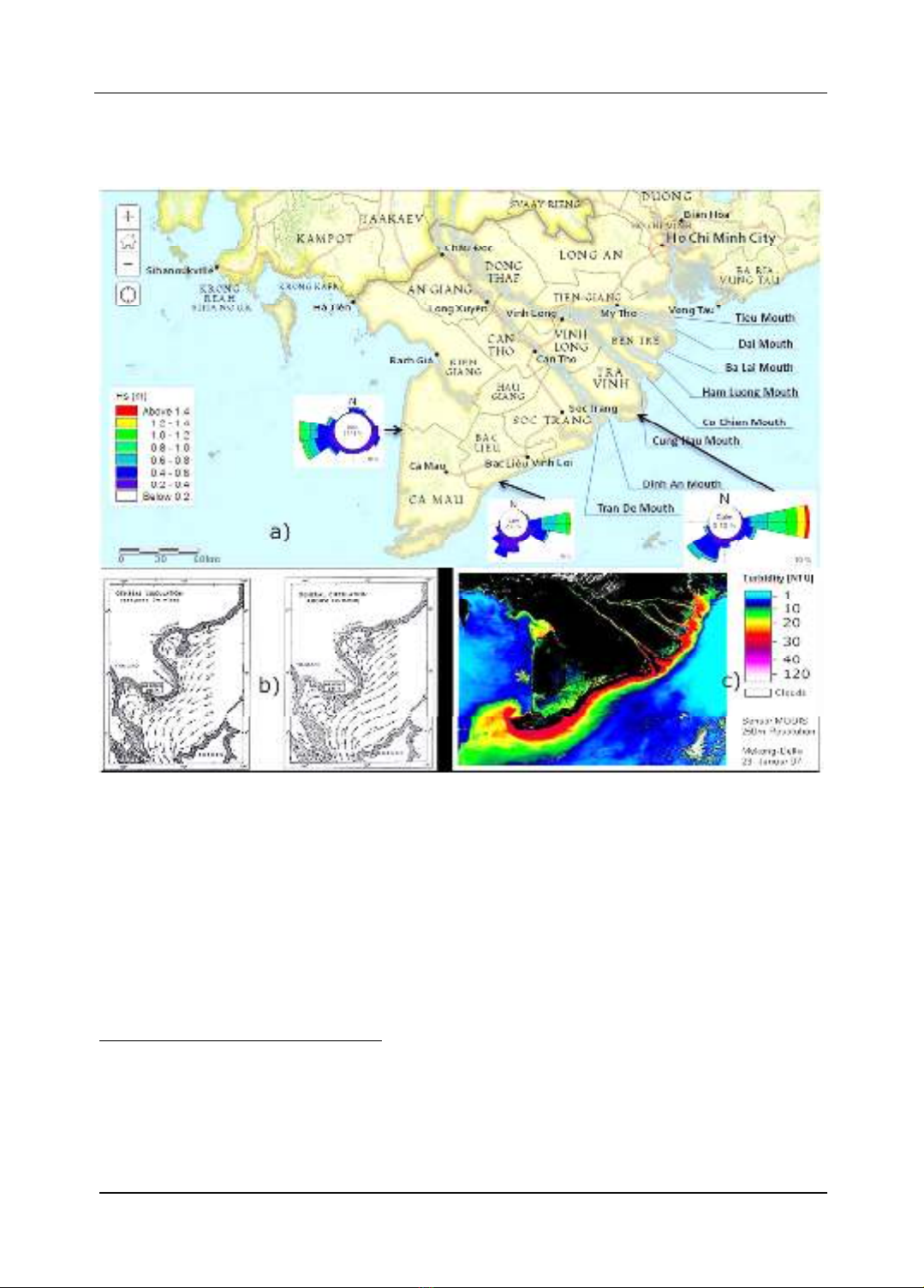
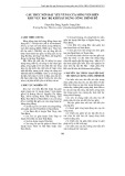
Figure 1. Map of Vietnamese Lower Mekong Delta and near shore wave roses (a), wind
directions in winter (b-left) and summer (b-right), and sediment concentration (turbidity) in
winter (c)1
However, the LMD is impacted by the development of the Upper Mekong
countries and also by influences from the East Sea. In the context of climate change, sea
level rise and especially the development of upstream countries, the risk of floods,
drought, salinity intrusion, erosion and deposition in the rivers, canals and coastal areas
of the LMD are great challenges.
1 a) Map of Vietnamese Lower Mekong Delta and nearshore wave roses (Source: SIWRR)
b) Winter and Summer ocean currents on the East Coast. Arrows denote the average flow direction, the
figures indicate the average flow rate in units kn (1 kn ≈ 0:51 m / s) (Source: U.S. Naval Occeanographic
Office, 1957)
c) Distribution coastal turbidity in the Lower Mekong Delta during the NorthEast monsoon (1/2007) built
from MODIS satellite image analysis (Source: EOMAP)
VIEÄN KHOA HOÏC THUÛY LÔÏI MIEÀN NAM
TUYEÅN TAÄP KEÁT QUAÛ KHOA HOÏC & COÂNG NGHEÄ 2017 - 2018
283 VIEÄN KHOA HOÏC THUÛY LÔÏI MIEÀN NAM
This paper discusses the existing shoreline, related impacts on sea dyke and shore
protection works, and presents an oriented solution for the stability of the LMD coastal area.
2. METHODOLOGY
The erosion, deposition, mangrove forest belts variation of coastal areas in the
LMD were reviewed and synthesized from previous projects of Chuong et al. (2008)
and Tuan et al. (2004) where satellite images with GIS method combined with field
observations (by GPS) were used to estimate erosion and deposition rates. The
mangrove forest belts and erosion/deposition rate have been recently updated (2016)
thank to Google earth toolbar where historical imagery and time slider are used to move
between acquisition dates. Most of available high resolution (1 meter) of Landsat
images are used (from 2000 to 2016). In addition, landmarks (such as houses, buildings)
are also used to correct the erosion/deposition rate results.
Sea dyke and shore protection works in the LMD are also field examined. The pros
and cons of them have been observed and examined from field survey as well as
referred to related literatures. Then the oriented solutions are proposed based on lessons
learned from protection measures.
3. RESULTS
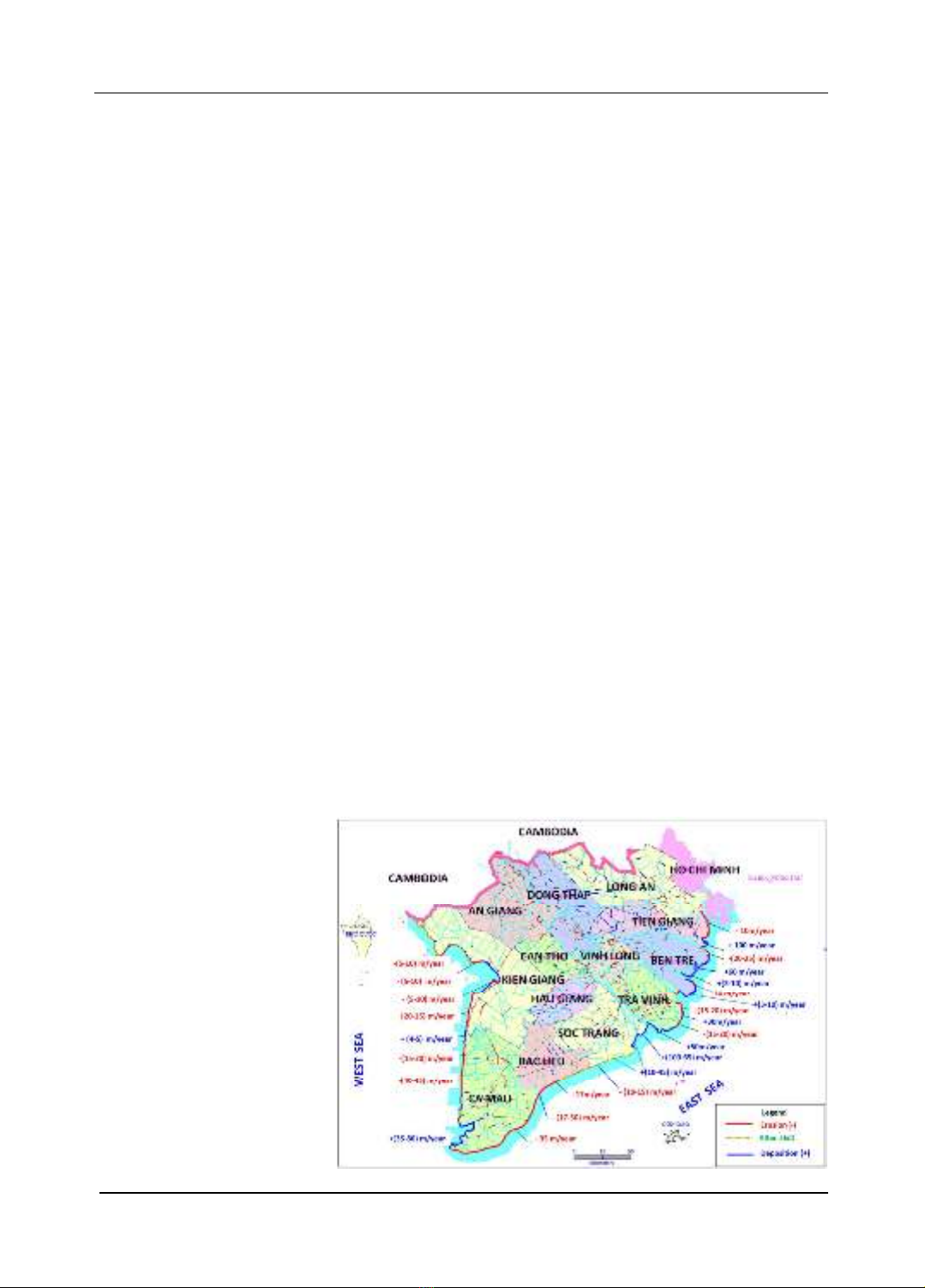
3.1. Existing and shoreline variation
The coastal-strip length from the Ho Chi Minh City to Kien Giang is about 774
km. The variation trends show constantly increasing erosion and reducing deposition,
causing damage to mangrove forests, land loss and threats to sea dyke systems - the
final defenses that protect inland production areas in the Delta from waves, storms
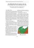
surges, etc. Figure 2 expresses the recent rates in m/year of erosion (red color),
deposition (blue color) and alternative erosion and deposition (dash green color) which
were synthesized from previous projects of Chuong et al. (2008) and Tuan et al. (2004)
and updated by Google earth maps overlaid in 2016.
Figure 2.
Existing erosion
and deposition situation
along the coastline of
LMD
283

TUYEÅN TAÄP KEÁT QUAÛ KHOA HOÏC & COÂNG NGHEÄ 2017 - 2018
VIEÄN KHOA HOÏC THUÛY LÔÏI MIEÀN NAM 284
Tien Giang province
In recent years, the 17 km key sea dyke at Go Cong Dong district, mangrove
forests have been gradually destroyed with increasing rate, up to 10 m/year. There is
only about 1.5 km of coastline which has been accreted about 10 - 15 m/year. The coast
between the Tieu and Dai river mouths experienced very strong accretion with an
average rate of 100 m/year.
Ben Tre province
The coastline of the Ba Tri and Binh Dai districts has not eroded, except for the
Dai river mouth, which has a maximum erosion rate of 25 m/year whereas the Ba Lai
river mouth has strongest deposition rate of 60 m/year. From the Ham Luong to Co
Chien River mouths, deposition prevails. From 1989 to date, alternative erosion and
deposition have taken place. From the Ham Luong river mouth southward 7 km the
erosion rate has been about 30 m/year. From that point to Co Chien river mouth, the
deposition rate has been about 60 m/year.
Tra Vinh province
In 50 km coastline, a part of 25 km from the Cung Hau river mouth to Dan Thanh
hamlet has an erosion rate of 15 - 20 m/year whereas from Dan Thanh hamlet to the Dinh
An river mouth has generally been deposited with the largest rate of 50 m/year to date.
Soc Trang province
The 12 km long of Cu Lao Dung coastline has been deposited with the rate over
100 m/year from 1965 to 1989 and then reduced to 65 m/year up to date. The 8 km from
the Tran De to the My Thanh river mouth, from 1965 to 1989 deposition rate was 10 -
15 m/year and 20 - 40 m/year to date. From the My Thanh river mouth to Bac Lieu
province, about 52 km length of the Vinh Chau district, erosion and deposition have
alternated. From 1989 to 2001, from Vinh Chau town to Bac Lieu province erosion
occurred at a rate of about 10 m/year. The current erosion rate is about 15 m/year. At a
location near Bac Lieu province, erosion has extended into the base of the sea dyke.
Bac Lieu province
With the coastline length of 56 km, from 1965 to 2008 there was seaward
deposition, except 6 km near Soc Trang province and 9 km near the Ganh Hao river
mouth, where erosion rate was 10 m/year. During the period 1965 - 1989 the Ganh Hao
river mouth erosion rate was 17 m/year and then up to 50 m/year over the period 1989 –
2001 before it was protected by a revetment.
Ca Mau province
From 1965 to date the 100 km East Sea coastal section has eroded at a rate of 35
m/year causing an area more than 1.5 km width lost to the sea. The 154 km long the
West Sea coast experienced alternating erosion and deposition in previous years but
increasing erosion rate recently. The largest deposition rate occurred at Ca Mau Cape.
From 1965 to 2001, an area approximately 3 km width expanded seaward at an average
VIEÄN KHOA HOÏC THUÛY LÔÏI MIEÀN NAM
TUYEÅN TAÄP KEÁT QUAÛ KHOA HOÏC & COÂNG NGHEÄ 2017 - 2018
285 VIEÄN KHOA HOÏC THUÛY LÔÏI MIEÀN NAM
rate of about 80 m/year. From 2001 to date, the deposition rate has reduced to 35 m/year
at the Cape.
Kien Giang province
Being influenced by the West Sea and the Gulf of Thailand, this coastal strip is
quite stable and deposition is the main occurrence in the past. From 1965 to 2008
deposition occurred at a rate of 5 – 10 m/year at the An Bien and An Minh district border
and expanded by about 2 km at a rate of 50 m/year. However, in recent years erosion has
occurred and threatened the safety of sea dykes in some local areas at An Minh – An
Bien, Mui Ranh, and Vam Ray. The maximum erosion rate reaches to 45 m/year to date.
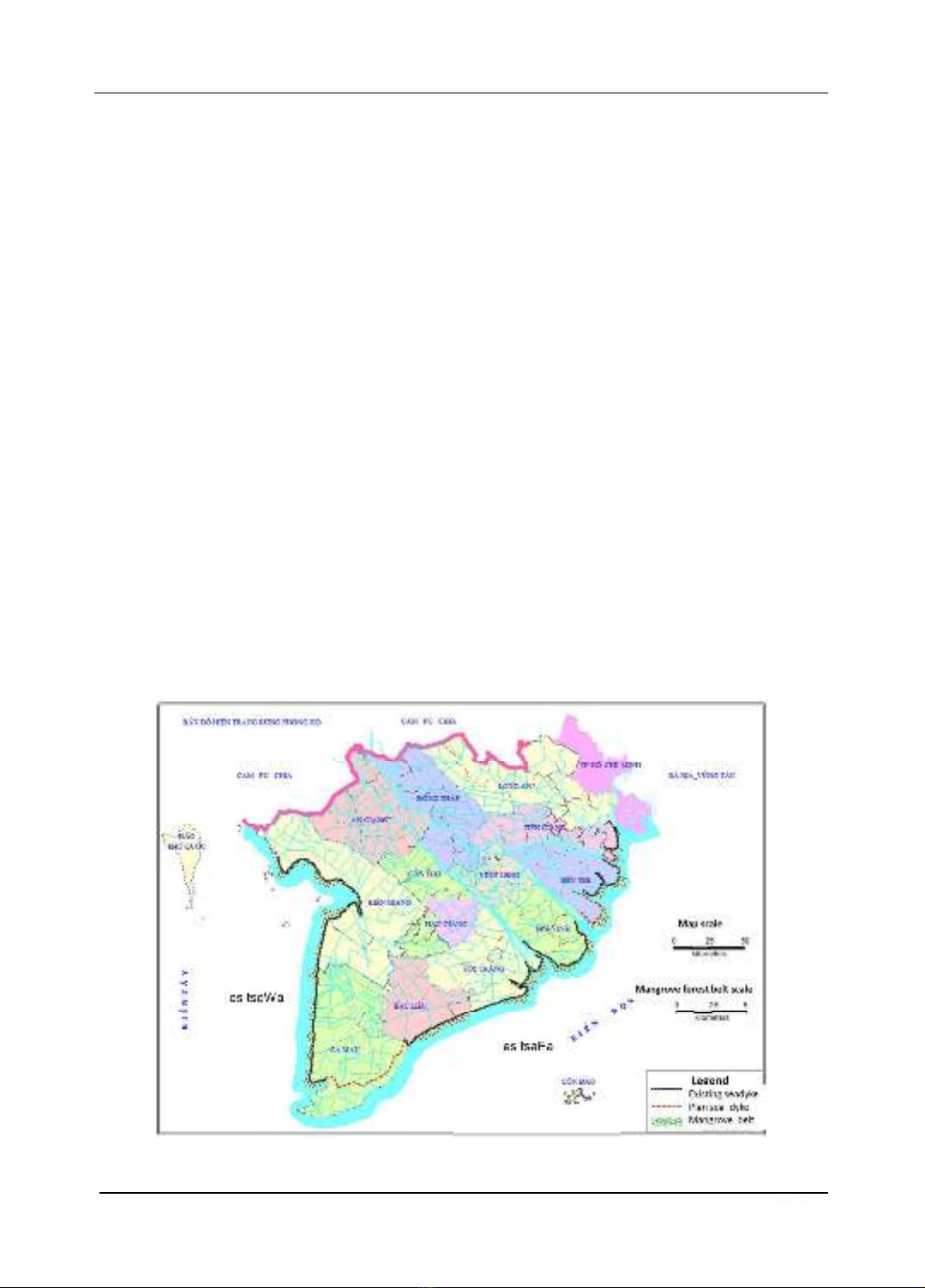
3.2. Existing sea dyke and mangrove forest belt
Sea dyke system in the LMD had been developed for few decades. The dykes
were, on average, 2 m of height, 6 m of width, with seaward slope of 1:3 and shoreward
slope of 1:2. Most of slope protection were grass cover.
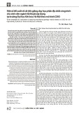
Total length of sea dykes in the LMD is about 630 km (Fig. 3). Sea dykes were
built on soft/weak soil with a small loading and slow consolidation capacity. Sea dykes
were made of in-situ soil and protected by the mangrove forest seaward.
The LMD has a mangrove forest area of about 51,000 ha. Because erosion and
human activities e.g. cutting forest for aquaculture and inshore fishing, the loss of
coastal mangroves is around 500 ha/year (about 1%). Currently, many coastal parts of
Bac Lieu, Ca Mau and Kien Giang have no mangrove forest belt seaward of the sea
dykes. The largest mangrove forest belt width in the LMD is less than 1 km.
Figure 3. Existing sea dykes and mangrove forest belt in the LMD
aWest se
aEast se
285


![Bài giảng Quản lý vận hành và bảo trì công trình xây dựng [chuẩn nhất]](https://cdn.tailieu.vn/images/document/thumbnail/2025/20251006/agonars97/135x160/30881759736164.jpg)