
Journal of Science and Technique - Vol. 19, No. 03 (Nov. 2024)
86
TRAJECTORY PLANNING FOR SEARCH-AND-RESCUE UAVs
USING A GREEDY ALGORITHM
Dinh Dung Nguyen1, Anh Tuan Nguyen1, Ngoc Hoa Nguyen1, Ngoc Linh Nguyen2,*
1Faculty of Aerospace Engineering, Le Quy Don Technical University
2International School, Vietnam National University, Hanoi
Abstract
This article presents a trajectory-planning program for research-and-rescue UAVs based on
the use of a local optimization greedy algorithm. Trajectories are generated over a search
domain characterized by a probabilistic score map. For multiple-UAV systems, the program
can assign each device to a search mission based on the probabilistic property or the
geometry of the search domain. Some parameters such as the maximum travelled distance
and trajectory resolusion could be input into the program. In this study, the program was
tested to run for a two-UAV system over a given probabilistic score map. The input
trajectory paremerters were selected based on the properties of each UAV and the
requirement of a search-and-rescue mission. The program may be seamlessly integrated
with UAV flight control software, enabling a direct translation of the obtained trajectories
into autonomous mission execution.
Keywords: UAV; search and rescue; greedy algorithm; trajectory planning.
1. Introduction
Unmanned aerial vehicles (UAVs) have been developed and widely used in many
fields of life, society, and national security. The current types of UAVs are diverse in
terms of characteristics, such as fixed-wing UAVs with the ability to operate over a
wide range and at high speeds; multirotor UAVs with the advantage of hovering,
observation, and target tracking capabilities; and hybrid VTOL (vertical take-off and
landing) UAVs that can combine the advantages of fixed-wing and multirotor UAVs.
One of the practical and essential applications of UAVs is to support search-and-rescue
(SAR) operations and to mitigate the impact of accidents, natural disasters, and
incidents. For this type of mission, flight trajectory-planning for UAVs must ensure the
coverage of sufficiently wide airspace while maximizing the probability of detecting the
target in the shortest possible time. Research on UAV trajectory optimization has been
of interest for recent years, in parallel with the application and development of
algorithms such as Particle Swarm Optimization (PSO) [1], graph search algorithms like
Dijkstra, A*, Theta* [2, 3], genetic algorithms [4], and potential field methods [5].
* Corresponding author, email: nlnguyen@vnu.edu.vn
DOI: 10.56651/lqdtu.jst.v19.n03.806

Tạp chí Khoa học và Kỹ thuật - ISSN 1859-0209
87
However, these algorithms mainly focus on finding the globally optimal trajectory when
the destination is known. For SAR UAVs, trajectories are complex due to the
uncertainty of final destinations. Hence, locally optimal algorithms like the greedy
algorithm are often used and combined with other techniques to enhance the
applicability [6].
Researchers have studied the use of UAVs for SAR missions. In the study by
Chen et al. [7], the importance of incorporating environmental information into the
path-planning process for UAV was emphasized. The authors proposed an online
approach that leverages the spatial correlation among target locations. Another piece of
research introduced an integrated assessment and search planning framework tailored
explicitly to 3D environments [8]. Additionally, some work has considered the
optimization of data transmission and surveillance path planning for UAVs [9]. More
recently, Wan et al. focused on the tradeoff between flight path length and terrain threat,
presenting an accurate 3D path planning method based on a multi-objective swarm
intelligence algorithm [10]. Collectively, these contributions highlight the significance
of factors such as environmental awareness, data communication, and comprehensive
path optimization in enhancing the effectiveness of UAV-based SAR operations.
For domestic UAV research, scientists have been focusing more on integrating
hardware systems and application technologies for UAVs rather than delving into
algorithm and software development [11, 12]. Optimal trajectory/path planning
algorithms are usually applied to robots [13, 14] rather than UAVs. One reason is that
UAVs and other aerospace objects are still relatively new. Some authors have studied
global UAV trajectory optimization algorithms under different flight conditions based
on graph search methods [15]. However, these algorithms do not apply to SAR UAVs,
which require comprehensive search coverage in a wide spatial area.
In this study, a program platform is presented for SAR UAVs based on an
improved greedy algorithm. The algorithm can be applied simultaneously to a system
with multiple UAVs deployed in parallel based on the search area's characteristics and
each UAV’s capabilities.
2. Methodology
2.1. Probabilistic score map and search domain
The rectangular search domain is modelled as a probability distribution of detecting
the missing object. In this study, the search domain is discretized into a Cartesian grid,
and the probability of detecting the missing object at grid node (i, j) (i-th along the x-axis
and j-th along the y-axis) is assumed to follow the Gaussian distribution:
Journal of Science and Technique - Vol. 19, No. 03 (Nov. 2024)
88
2
2
2
2
12
s
k ij
sk
N
ij k
kk
e
pw
rr
(1)
where Ns is the number of probability distribution sources within the search domain;
rij and
s
k
r
are the position vectors at grid node (i, j) and the k-th source, respectively;
σk and wk are the standard deviation of the probability distribution and the weight of the k-th
source. These weights represent the degree of influence of each source and are normalized
to ensure that the total probability over all grid nodes in the search domain is 1.
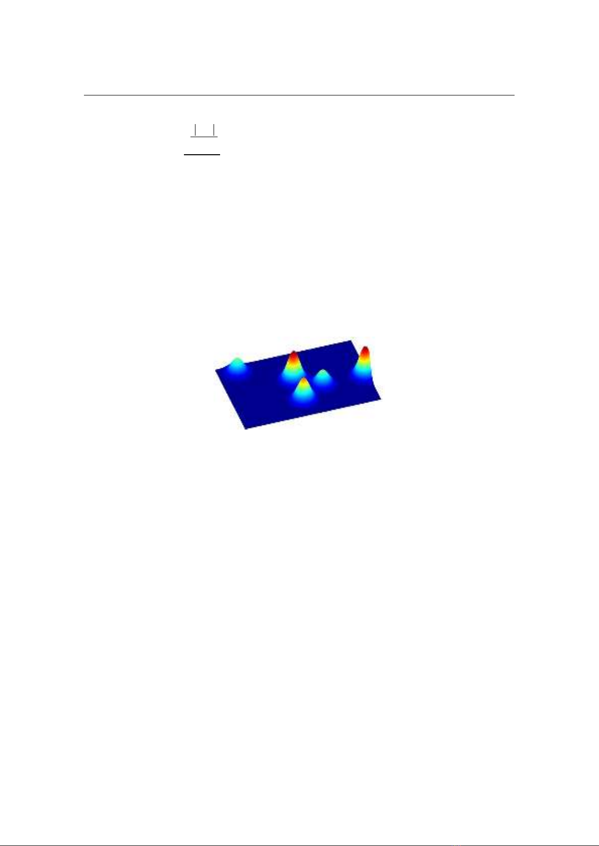
Figure 1 illustrates the probabilistic score map in the search domain with five
hypothetical sources. Here, the position vector, the magnitude and the weight of each
source are given; and the probabilistic score on each node is calculated by Eq. (1).
Fig. 1. Score map showing the probability distribution of detecting the missing object.
2.2. The greedy algorithm and trajectory-planning program
This study uses the greedy algorithm [6] to determine an appropriate trajectory of
the UAV to maximize the accumulative probability of detecting objects. Compared to
other globally optimal path-planning methods [1-5], this approach is more efficient in
generating wide-coverage trajectories. Instead of considering the whole map, the greedy
algorithm focuses on only neighboring nodes, and attempt to move the node of the highest
probability. Figure 2 shows the current node and its neighboring nodes, to which the UAV
can move in the next step. The visited node is then marked on the map and is prevented
from revisiting, except for special cases. To generate a suitable trajectory, some
improvements to the algorithm are introduced. Specifically, when all neighboring grid
nodes have been marked, the UAV is trapped; it is then guided to the unmarked grid node
with the highest probability within the whole search domain. The program is terminated
when the UAV has visited all the grid nodes in the search area or the total flight distance
(including the travelled distance and that expected to return to the starting position)
exceeds the allowed value. The details of the algorithm are show in Fig. 3.
Tạp chí Khoa học và Kỹ thuật - ISSN 1859-0209
89
Current node
Fig. 2. Current and neighboring grid nodes.
Read map and
input
Start
If all
neighboring
nodes have
been visited
Go to the highest-
probability
neighboring node
Move towards the
highest-
probability node
in the map
Check the
terminating
conditions
Stop
Update
probabilistic
score map
Fig. 3. Current and neighboring grid nodes.
The search area of each UAV may be defined either based on the geometry or the
probabilistic property. The algorithm can be applied to a system of UAVs, in which,
each UAV is responsible for a searching mission within a predefined probability range
or a given area.
The trajectory-planning program was developed to run in the MATLAB
environment with the source code written in FORTRAN. The program uses the graphics
of MATLAB to draw maps and flight paths.
Journal of Science and Technique - Vol. 19, No. 03 (Nov. 2024)
90
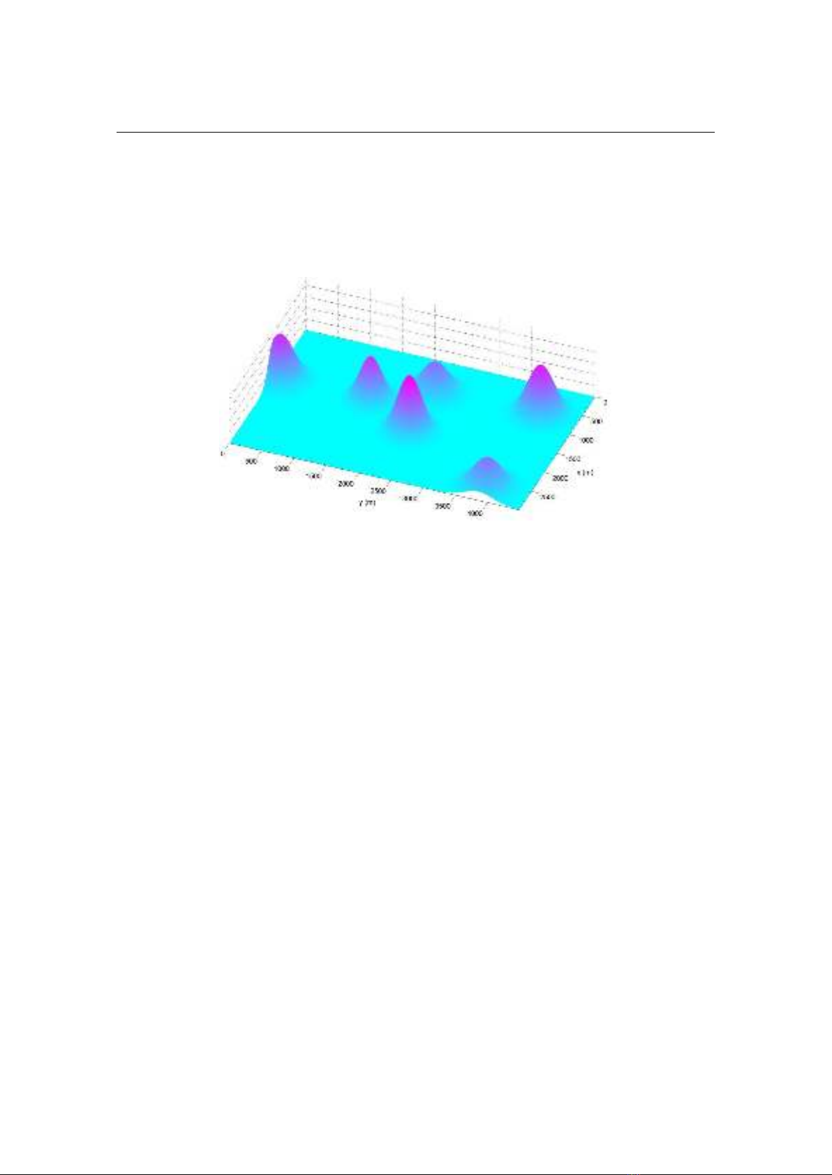
3. Simulation results and discussion
The algorithm was tested by running simulations to search within a
3 4.5
km
rectangular domain. Figure 4 illustrates the probability distribution of detecting the
mission object in this domain.
Fig. 4. Probability distribution of detecting the mission object.
The algorithm was applied to a system of two UAVs. For the first case, a search
mission was assigned to each UAV based on the probabilistic property. UAV1 was set
to search areas covering 60% highest probability while UAV2 was assigned to the
search mission over the remaining areas. The resolutions in the search map for UAV1
and UAV2 are 50 m and 200 m, respectively. The resulting trajectories of the two
UAVs are shown in Fig. 5. The flight distance travelled by UAV1 and UAV2 are 37 km
and 119 km, respectively. It is noted that the trajectory resolution of each UAV could be
selected based on the properties of on-board devices such as cameras used for the search
mission. Moreover, constrains in the flight maneuver of each UAV also needs
considering while setting the input parameters of the program. For fixed-wing aircraft,
due to the constraint on the minimum flight-path radius, lower map-resolution may be
applied. The grid size cannot be smaller than the allowed minimum radius. For
quadrotors, this type of constraint may be released.
Figure 6 shows the variation of normalized probability score of each UAV during
the search mission. It is obviously observed that UAV1 is in charge of high-probablity
regions (over 0.4), while UAV2 operates in the below 0.4 probability score regions.
While searching based on geometry, we can obtain the trajectories as shown in
Fig. 7. In these cases, two UAVs are assumed to have the same trajectory resolution.


![Bài giảng Thiết kế điều khiển 2 [mới nhất]](https://cdn.tailieu.vn/images/document/thumbnail/2025/20250516/phongtrongkim0906/135x160/5221747448741.jpg)


![Bài giảng Lý thuyết điều khiển TS. Nguyễn Thu Hà [mới nhất]](https://cdn.tailieu.vn/images/document/thumbnail/2025/20250515/hoatrongguong02/135x160/241747304992.jpg)


![Trắc nghiệm Điều khiển tự động [mới nhất]](https://cdn.tailieu.vn/images/document/thumbnail/2025/20250924/kimphuong1001/135x160/96131758686268.jpg)