Journal of Science and Transport Technology Vol. 4 No. 3, 39-52
Journal of Science and Transport Technology
Journal homepage: https://jstt.vn/index.php/en
JSTT 2024, 4 (3), 39-52
Published online 21/09/2024
Article info
Type of article:
Original research paper
DOI:
https://doi.org/10.58845/jstt.utt.2
024.en.4.3.39-52
*Corresponding author:
Email address:
hienhtt@utt.edu.vn
Received: 29/07/2024
Revised: 17/09/2024
Accepted: 19/09/2024
Enhancing Inland Waterway Safety and
Management through Machine Learning-
Based Ship Detection
Dung Van Tran1, Thu-Hien Thi Hoang2,*, Hai-Bang Ly2
1Port Authority of Inland Waterway Area 1, VIWA, Vietnam
2University of Transport Technology, Hanoi 100000, Vietnam
Abstract: Efficient ship detection is essential for inland waterway
management. Recent advances in artificial intelligence have prompted
research in this field. This study introduces a real-time ship detection model
utilizing computer vision and the YOLO object detection framework. The model
is designed to identify and locate common inland waterway vessels, such as
container ships, passenger vessels, barges, ferries, canoes, fishing boats, and
sailboats. Data augmentation techniques were employed to enhance the
model's ability to handle variations in ship appearance, weather, and image
quality. The system achieved a mean Average Precision (mAP) of 98.4%, with
precision and recall rates of 96.6% and 95.0%, respectively. These results
demonstrate the model's effectiveness in practical applications. Its ability to
generalize across diverse vessel types and environmental conditions suggests
its potential integration into video surveillance for improved maritime safety,
traffic control, and search and rescue operations.
Keywords: Computer Vision; Ship Detection; YOLOv8 algorithm; Artificial
intelligence; Roboflow platform;
1. Introduction
Ship detection in waterways is crucial for
diverse maritime management applications.
Accurate identification of vessels is the initial step
in tracking their positions, movement patterns, and
other pertinent data. This task is essential for the
surveillance of both inland and international
waterways [1, 2]. In the civilian sector, ship
detection aids traffic regulation, mitigates the risk
of collisions and accidents, and ensures vessel
safety. It also facilitates infrastructure planning,
improves cargo transport efficiency, and
contributes to environmental protection.
Additionally, it provides essential data for urban
planning along waterways and for responding to
emergencies. Precise ship detection is therefore a
key factor in enhancing the overall management
and fostering the sustainable development of
waterways, particularly inland waterways.
Multiple technologies and methods currently
exist for ship detection in inland waterways.
Among these methods, radar is widely used [3–6].
Radar systems detect and track vessels within a
designated area, operate under all weather
conditions, and provide precise information about
vessel location and movement. However, this
method presents some challenges, notably high
installation and maintenance costs and the
necessity for human interpretation and data
analysis. Surveillance camera systems installed at
strategic locations along waterways capture visual
data of traffic conditions. These systems may also

JSTT 2024, 4 (3), 39-52
Tran et al
40
incorporate pressure and sound sensors for vessel
detection and tracking [7]. This approach offers the
advantage of providing direct visual information
about the waterway traffic; however, its
effectiveness can be hindered by weather and
lighting conditions and requires substantial data
storage and analysis. Automatic Identification
Systems (AIS) enable vessels to transmit and
receive information regarding their position, speed,
course, and other relevant data [8–10]. This
system allows authorities and traffic management
to monitor vessel activities in real time. It also
readily integrates with other technologies, such as
radar and GPS. However, AIS requires vessels to
be equipped with compatible devices and may
experience limitations in areas with weak or absent
signal coverage. Other ship detection approaches
employed globally include Global Positioning
Systems (GPS) [11, 12], remote sensing and
satellite imagery [13, 14], and sonar hydroacoustic
sensors [15]. Each of these methods presents
unique advantages and disadvantages, with the
selection of an appropriate method depending on
specific requirements, environmental factors, and
budgetary constraints.
Existing ship detection methods for waterway
management are often limited by cost and
accuracy, and their performance is often affected
by weather and environmental factors. Modern
river and inland waterway management faces
additional challenges such as increased vessel
traffic, illicit activities, and personnel shortages
[16]. The continuous rise in vessel traffic in rivers
and inland waterways not only places a burden on
the transportation system but also elevates the risk
of collisions and accidents. Illegal activities, such
as smuggling and unauthorized resource
extraction, pose threats to both the environment
and security. Additionally, relying on manual
surveillance is expensive and risks human error. To
address these issues, the development of
automated, efficient, and affordable ship detection
methods is crucial.
In recent years, spurred by the rapid
advancement of the fourth industrial revolution,
Artificial Intelligence (AI) has found growing
applications across various societal sectors [17].
AI, a field in computer science, focuses on creating
computer systems capable of performing tasks that
typically require human intelligence. Machine
learning (ML), a subset of AI, involves the
development of techniques that enable systems to
learn from data and solve specific problems. By
constructing models for image-based object
recognition, AI and ML have been explored for
application in fields such as transportation [18],
healthcare [19], agriculture [20], and retail [21].
These advances have led to AI and ML becoming
integral components of science and technology,
offering solutions to various problems through
intelligent automation. Automating ship detection
using AI and ML offers several benefits [22]. This
enables continuous, 24/7 surveillance of all vessels
in a defined area, thereby enhancing the overall
monitoring efficiency. Automation also reduces the
risk of violations and accidents by quickly
identifying rule infractions and providing warnings
about potential collisions. In addition, incorporating
AI and ML into maritime surveillance systems
improves their adaptability and dependability.
With the progress of AI, numerous studies
have investigated ML models for ship detection.
The key criteria for these models include the
capacity to identify ships from different
perspectives, detect various ship types, and
achieve high accuracy. Recent research has
focused on enhancing ship detection under low
visibility conditions and across diverse image
scenarios, as demonstrated by Liu et al. [23]. In this
study, they applied AI and ML models, including
Random Forest, Decision Tree, Naive Bayes, and
Convolutional Neural Network (CNN), to 4000
satellite images of ships, resulting in a robust ship
detection model [24]. Among these models,
Random Forest demonstrated the highest
accuracy, achieving 97.2% with Red Green Blue
(RGB) images and 98.9% with Hue, Saturation,
and Value (HSV) images. Additional research has
JSTT 2024, 4 (3), 39-52
Tran et al
41
explored ML models for ship detection based on
radar and remote sensing data [25–27]. However,
to date, few studies have utilized ML to develop a
ship detection model based on surveillance
camera imagery. This highlights the need for a
robust AI/ML model capable of accurately
recognizing various ship types from multiple
angles. This research introduces a real-time ship
detection model that utilizes YOLO V8 and trained
on a diverse dataset of 17,707 images, with a
particular focus on leveraging surveillance camera
imagery, an approach not extensively explored in
previous studies.
2. Database description and analysis
The dataset used in this study comprises
17,707 images sourced from two primary locations:
(1) 756 images of various ship types, including
container ships, passenger vessels, barges,
ferries, canoes, fishing boats, and sailboats,
captured by the authors using a smartphone and
collected from the internet; and (2) 16,951 images
obtained from open database repositories.
To ensure dataset diversity and cover a wide
spectrum of real-world scenarios, the selected
images include various ship types, hull sections,
scales, viewpoints, lighting conditions, positions
within the frame, and occlusion levels. The images
also depict ships in complex environments. All
images in the dataset were manually labeled with
precise ship annotations and bounding boxes
using the Roboflow platform, a tool designed for
computer vision data management and
preparation. The dataset was divided into three
subsets for model development and evaluation:
training (80%), validation (10%), and testing (10%).
The training set is used to train the ML model,
allowing it to learn features and make predictions.
The validation set helps adjust model
hyperparameters and monitor training progress.
The test set provides an independent model
performance assessment. A sample of the
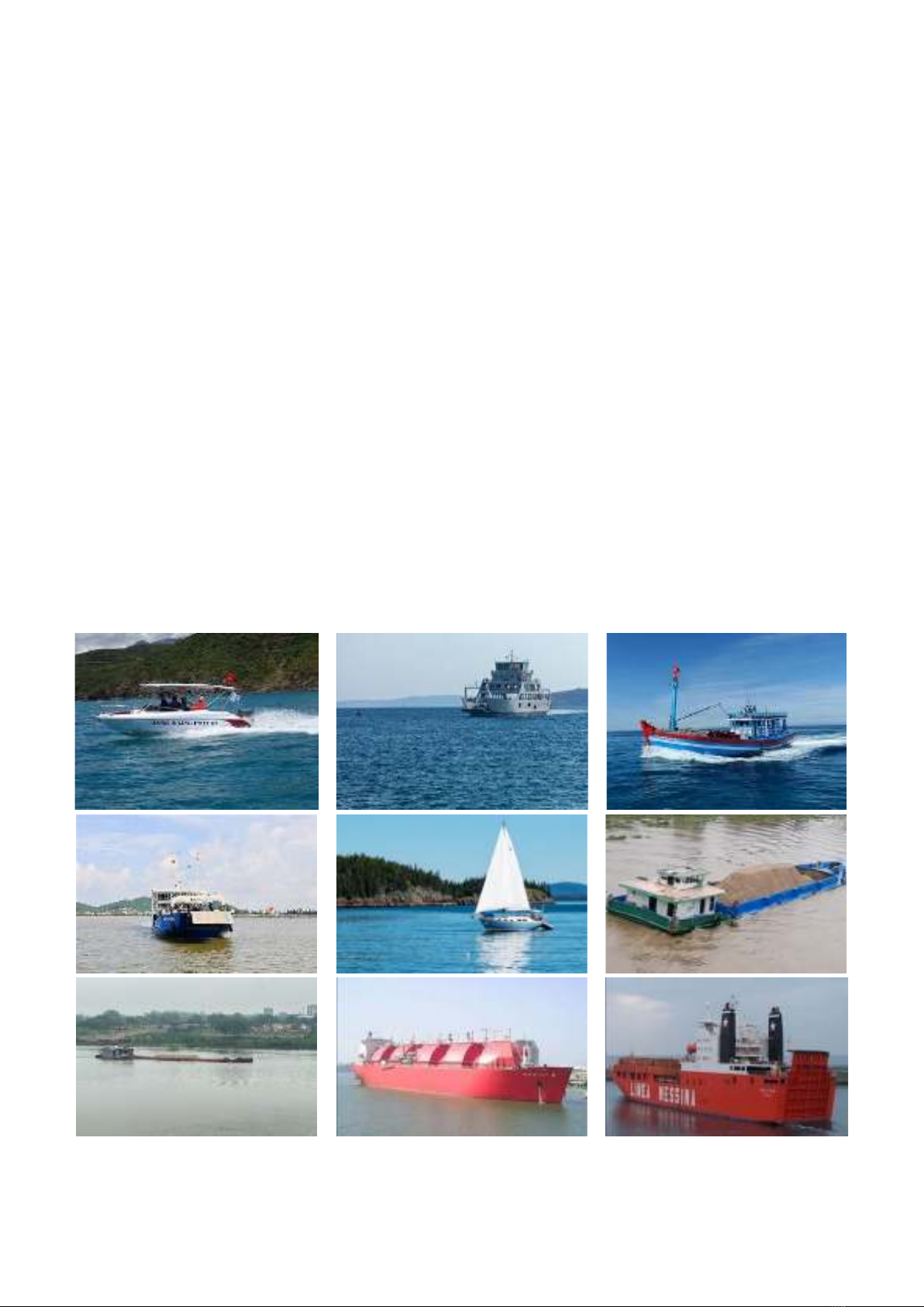
collected data is shown in Figure 1.
Fig. 1. Illustration of images collected in the dataset (includes open-source images from various online
repositories)
JSTT 2024, 4 (3), 39-52
Tran et al
42
3. Machine learning Methods
3.1. YOLO
3.1.1 Introduction of YOLO
YOLO (You Only Look Once), a computer
vision algorithm introduced in 2015 by Joseph
Redmon, is designed to detect objects in images
[28]. Unlike traditional methods, which often
require multiple processing steps, YOLO's unique
architecture enables it to predict both bounding
boxes and object classes in a single pass of an
image. This streamlined approach results in
exceptional computational efficiency, and thus,
YOLO is particularly well-suited for real-time
applications in which rapid object detection is
essential [29]. For example, in autonomous
vehicles navigating complex urban environments,
the onboard computer vision system must rapidly
and accurately identify pedestrians, other vehicles,
and traffic signs. YOLO's ability to process an
entire image and generate all necessary
predictions simultaneously makes it a strong
candidate for such tasks. This real-time capability
is vital for ensuring the safety and responsiveness
of self-driving cars. In addition to its speed
advantage, YOLO has received recognition for its
accuracy. Since its initial release, multiple versions
of YOLO have been developed, each iteratively
improving both speed and accuracy. This ongoing
development has made YOLO a popular choice for
various object detection applications, including
security, surveillance, robotics, and industrial
automation [29].
3.1.2. YOLO working mechanism
The YOLO model, which was initially trained
on the ImageNet dataset, was adapted for object
detection [28,30]. The final layer predicts both the
likelihood of an object belonging to a specific class
and the coordinates defining its location in the
image. YOLO realizes this by partitioning the input
image into an S x S grid. Each cell in the grid is
tasked with detecting objects whose centers fall
within its boundaries. Each cell generates multiple
bounding box predictions, each with an associated
confidence score indicating the model's certainty
that the box contains an object and the accuracy of
its prediction. To refine the output, YOLO selects
the most accurate bounding box for each individual
cell. This is achieved by calculating the Intersection
over Union (IOU), which is a metric measuring the
overlap between the predicted and actual bounding
boxes, and selecting the box with the highest IOU.
Non-maximum suppression (NMS) further
improves YOLO's accuracy by eliminating
redundant or inaccurate bounding boxes after the
initial predictions. This ensures that each object is
represented by a single, well-defined bounding
box.
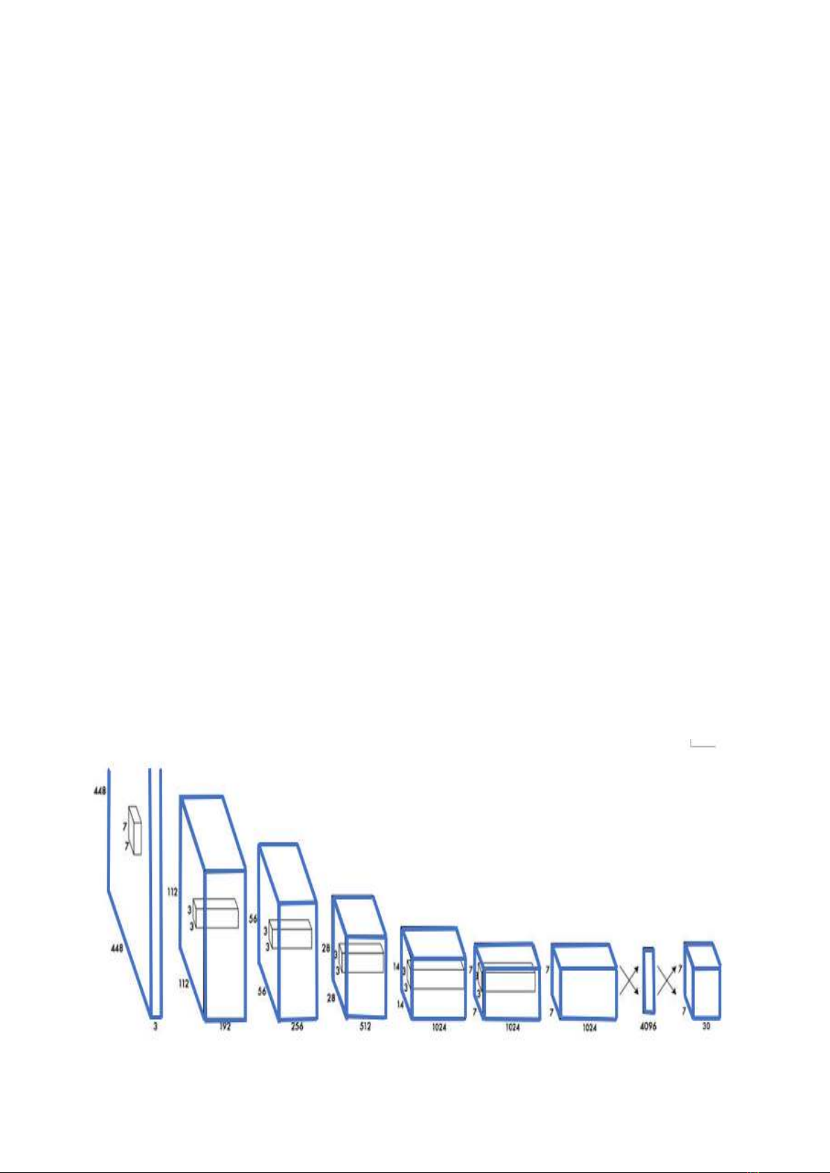
Fig. 2. Illustration of YOLO’s structure (adapted from [30])
JSTT 2024, 4 (3), 39-52
Tran et al
43
For instance, in an image of multiple ships,
YOLO first divides the image into a grid. Each cell
then analyzes its assigned area and predicts
multiple bounding boxes for potential ships. YOLO
then calculates the IOU for each box, selecting the
one with the highest overlap with the actual ship.
Finally, NMS removes any redundant or
overlapping boxes, leaving only accurate bounding
boxes for each ship in the image. This multi-step
process allows YOLO to efficiently and accurately
detect objects in real-time, making it useful in
various applications, such as autonomous
vehicles, security systems, and industrial
automation.
3.2. Performance indices of model
Performance metrics are the primary tools to
assess the accuracy and effectiveness of object
detection models. The key metrics were mean
average precision (mAP), precision, and recall [29].
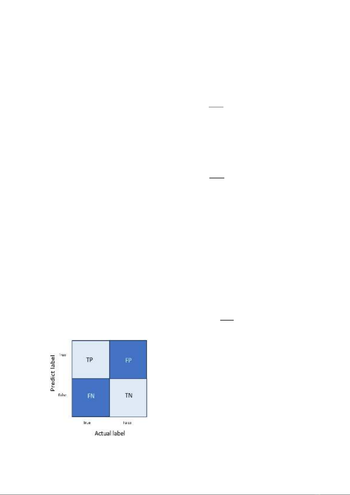
To understand these metrics, it is helpful to first
define four common variables using a binary
confusion matrix, as shown in Fig. 3. The axes of
this matrix represent two properties of the label:
'True' and 'False'. When both the actual and
predicted labels are 'True', the case is labeled as
true positive (TP). When both labels are 'False', it's
labeled as true negative (TN). False negative (FN)
denotes the situation where the actual label is
'True' but the predicted label is 'False'. Conversely,
false positive (FP) indicates that the actual label is
'False' while the predicted label is 'True' [31].
Fig. 3. Binary Confusion Matrix
Precision, ranging from 0 to 1, represents the
proportion of correctly predicted "True" labels
among all predicted "True" labels. In the ship
detection context, high precision indicates high
confidence in the identification of a specific ship
type:
P = TP
TP+FP ∈ [0, 1]
Recall, which ranges from 0 to 1, represents
the proportion of correctly predicted "True" labels
among the total number of actual "True" labels.
High recall for ship detection indicates the
algorithm's strong ability to detect all instances of a
particular ship type in the dataset:
R = TP
TP+FN ∈ [0, 1]
mAP is a metric used to evaluate the
performance of computer vision models. It is
calculated as the average of the Average Precision
(AP) metric across all classes in the model. The
mAP can be used to compare different models on
the same task or different versions of the same
model. Higher mAP values ranging from 0 to 1
indicate better performance. For a given category,
Average Precision (AP) refers to the area under the
curve plotted using recall and precision:
APi = ∫Pi
1
0(Ri)dRi
The mAP of multiple categories is defined as
follows:
mAP = ∑APi
n
1
n ∈ [0, 1]
In ML, optimizing the loss function is critical
for effective model training. For object detection
tasks using the YOLO algorithm, the loss function
is composed of three components: box loss, class
loss, and object loss.
Box loss measures the algorithm's capacity
to accurately locate an object's center and predict
its bounding box. It quantifies the discrepancy
between the predicted and actual bounding boxes
for objects in the training data. A smaller box loss
value indicates a close match between the
predicted and actual bounding boxes. Here, object
loss is the probability that an object exists within a


![Bài tập tối ưu trong gia công cắt gọt [kèm lời giải chi tiết]](https://cdn.tailieu.vn/images/document/thumbnail/2025/20251129/dinhd8055/135x160/26351764558606.jpg)