Transport and Communications Science Journal, Vol. 76, Issue 01 (01/2025), 64-78
64
Transport and Communications Science Journal
REAL-TIME MULTI-SENSOR FUSION FOR OBJECT
DETECTION AND LOCALIZATION IN SELF-DRIVING CARS: A
CARLA SIMULATION
Trung Thi Hoa Trang Nguyen1,2, Thanh Toan Dao2,*, Thanh Binh Ngo2
1Hanoi College of High Technology, Nhue Giang Street, Tay Mo Ward, Nam Tu Liem District,
Hanoi, Vietnam
2University of Transport and Communications, No 3 Cau Giay Street, Hanoi, Vietnam
ARTICLE INFO
TYPE: Research Article
Received: 10/12/2024
Revised: 06/01/2025
Accepted: 10/01/2025
Published online: 15/01/2025
https://doi.org/10.47869/tcsj.76.1.6
* Corresponding author
Email: daotoan@utc.edu.vn; Tel: +84979379099
Abstract. Research on integrating camera and LiDAR in self-driving car systems has
important scientific significance in the context of developing 4.0 technology and applying
artificial intelligence. The research contributes to improving the accuracy in recognizing and
locating objects in complex environments. This is an important foundation for further
research on optimizing response time and improving the safety of self-driving systems. This
study proposes a real-time multi-sensor data fusion method, termed "Multi-Layer Fusion,"
for object detection and localization in autonomous vehicles. The fusion process leverages
pixel-level and feature-level integration, ensuring seamless data synchronization and robust
performance under adverse conditions. Experiments conducted on the CARLA simulator.
The results show that the method significantly improves environmental perception and object
localization, achieving a mean detection accuracy of 95% and a mean distance error of 0.54
meters across diverse conditions, with real-time performance at 30 FPS. These results
demonstrate its robustness in both ideal and adverse scenarios.
Keywords: Camera-LiDAR Fusion, Real-Time, Object Detection, Object Localization,
Self-Driving Cars, CARLA.
@ 2025 University of Transport and Communications

Transport and Communications Science Journal, Vol. 76, Issue 01 (01/2025), 64-79
65
1. INTRODUCTION
In recent years, the advancement of autonomous driving technology has been driven by
the integration of sensor-based systems, with LiDAR emerging as a key player for
environmental perception [1-3].
Prominent companies like Waymo (Google) and Tesla have been pioneers in sensor
integration for autonomous systems. Waymo's system combines camera and LiDAR data to
enhance object detection and real-time decision-making, while Tesla focuses on multi-camera
setups complemented by LiDAR for precise object localization [4,5].
In our previous research [6], a single-beam LiDAR-based navigation system was
developed, utilizing neural networks to perform obstacle avoidance and ensure vehicle
navigation in controlled environments. This approach demonstrated notable effectiveness in
detecting and avoiding obstacles using cost-efficient and computationally lightweight setups.
However, it faced limitations when applied to real-world, complex environments, where
dynamic obstacles, varied lighting conditions, and intricate spatial layouts demand more
sophisticated perception capabilities.
To overcome these challenges, the integration of camera data with LiDAR offers a
compelling solution. Cameras excel in capturing high-resolution images, enabling advanced
object recognition and classification through visual processing. By fusing the spatial data from
LiDAR with the detailed imagery from cameras, the system can leverage the complementary
strengths of both sensors, significantly improving object detection, localization, and overall
environmental understanding.
This paper proposes a multi-layer data fusion framework that combines multi-beam
LiDAR and camera data for autonomous navigation in complex environments. The approach
addresses the limitations of single-sensor systems and enhances real-time decision-making by
incorporating:
• Layer 1 - Pixel-Level Fusion – Mapping LiDAR point clouds onto the camera’s image
plane to achieve spatial alignment between depth and visual information.
• Layer 2 - Feature-Level Fusion – Extracting and merging features from both sensors to
generate a unified dataset for robust decision-making processes.
The system integrates YOLOv8 for real-time object detection using camera data, while the
LiDAR sensor provides precise distance and angle measurements. The proposed fusion method
synchronizes data in both spatial and temporal domains, ensuring seamless integration and
accurate environmental perception.
Simulations conducted in the CARLA simulator validate the effectiveness of the proposed
method under varying environmental conditions, including complex traffic scenarios and
dynamic lighting. This enhanced framework not only demonstrates improved accuracy and
responsiveness but also holds significant potential for real-world applications, particularly in
the domains of dynamic obstacle avoidance and autonomous driving safety.
This research contributes to the development of safer and more efficient autonomous
systems capable of operating in real-world environments.
2. RELATED WORK
The integration of multi-sensor data, particularly from camera and LiDAR, has been a
critical focus in autonomous vehicle research. Existing methods can be categorized into three

Transport and Communications Science Journal, Vol. 76, Issue 01 (01/2025), 64-78
66
primary approaches: early fusion, late fusion, and hybrid fusion. Each approach has its
advantages and limitations, which have been extensively studied in the literature.
• Early Fusion: Raw sensor data is combined at the initial processing stages. For example,
X.Chen et al. (2017) proposed MV3D, which projects LiDAR point clouds onto a bird’s-eye
view and integrates them with camera image features for improved perception accuracy [7].
Similarly, J.Ku et al. (2017) introduced AVOD, which fuses raw sensor feature maps for robust
3D object detection [8]. These methods leverage raw data but face challenges due to their high
computational cost and stringent requirements for precise sensor synchronization. Moreover,
early fusion can struggle in dynamic environments where real-time processing is critical.
• Late Fusion: Sensor data is processed independently and merged during decision-
making. Geiger et al., (2012) demonstrated late fusion’s efficiency in reducing computational
overhead using the KITTI dataset [9]. However, this approach has limitations in unstructured
environments where the independence of sensor processing can lead to loss of spatial and
temporal alignment. Late fusion also suffers from difficulties in capturing inter-sensor
dependencies, which are crucial for complex perception tasks.
• Hybrid Fusion: Recent research emphasizes real-time multi-sensor integration using
hybrid approaches. For instance, Yin et al. (2020) integrated YOLOv4 with LiDAR for real-
time obstacle detection, achieving fast and accurate results [10]. Hybrid methods aim to balance
the strengths of early and late fusion but often require complex architectures and calibration.
In Vietnam, research remains in its early stages, with significant contributions from
universities and companies like Phenikaa Group, which integrates LiDAR and camera data for
urban autonomous vehicles. These efforts underscore the growing focus on sensor fusion for
enhanced perception and localization.
While the aforementioned methods have advanced object detection and localization, they
exhibit several limitations:
1) Environmental Conditions: Camera-based systems often fail in adverse conditions
like poor lighting, rain, or fog, while LiDAR systems struggle with highly reflective
or absorbent surfaces.
2) Real-Time Processing: Computational efficiency remains a significant challenge,
especially for methods relying on early fusion due to the volume of raw data.
3) Robustness: Many methods assume ideal conditions for both sensors, which limits
their effectiveness in real-world scenarios with dynamic obstacles and diverse
environmental factors.
To address these limitations, this paper proposes a multi-layer fusion approach that
integrates pixel-level and feature-level data from both sensors. By combining the high-
resolution imagery of cameras with the accurate spatial data of LiDAR, the proposed method
ensures robust perception across various lighting and weather conditions. Additionally, real-
time synchronization techniques mitigate latency issues, making the system practical for
dynamic environments.
3. PROBLEM FORMULATION
3.1. Proposed method and data fusion process
Transport and Communications Science Journal, Vol. 76, Issue 01 (01/2025), 64-79
67
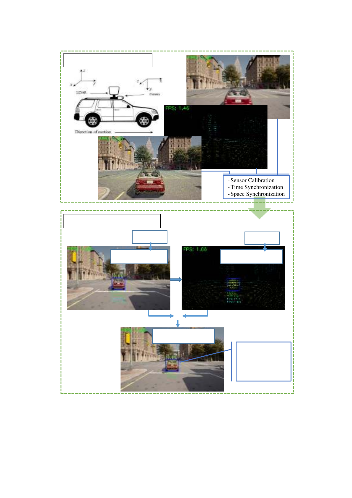
Figure 1. An illustration of the overall framework.
This section introduces a novel "Multi-layer fusion" method, which operates across two
layers: Pixel-level fusion and Feature-level fusion. The proposed approach optimizes the
advantages of each fusion method, enabling faster and more accurate system responses. An
overview of the proposed model is depicted in Figure 1.
- Sensor Calibration
- Time Synchronization
- Space Synchronization
Euclidean
Object Localization
Final Result
Object Detection
Layer 1: Pixel-Level Fusion
Layer 2: Feature-Level Fusion
YOLOv8
- Bounding box
- Class name
- Distance
- Angle

Transport and Communications Science Journal, Vol. 76, Issue 01 (01/2025), 64-78
68
• Layer 1: Pixel-Level Fusion
- Input: pixel data from camera and point cloud data from LiDAR
- Output: pixel coordinates
• Layer 2: Feature-Level Fusion
- Input: pixel coordinates
- Output: location and distance of object in 3D space
Here is the explanation of the mathematical details for the Multi-Layer Fusion method in
Pixel-Level Fusion and Feature-Level Fusion:
Algorithm Name: Multi-Layer Fusion for Camera-LiDAR Integration
Input:
• Camera data (Icamera): 2D image with pixel intensity values
• LiDAR data (PLiDAR): 3D point clound {(𝑥𝑖,𝑦𝑖,𝑧𝑖)}𝑖=1
𝑁, where N is the number of
LiDAR points.
• Camera Parameters: Intrinsic matrix K and extrinsic matrix [R t] for
transforming and aligning LiDAR data to the camera's coordinate frame.
Output:
• Fused image Ifused: A pixel-level combined representation of color and depth.
• Object-level features F: A set of features F={F1, F2 ,…, Fn}, where Fi includes
2D detection and 3D localization for each detected object.
# Pixel-level Fusion
1. Project the LiDAR point cloud PLiDAR onto the 2D camera plane using
perspective projection:
[𝑢
𝑣1]=𝐾∙[𝑅 𝑡
0 1]∙[𝑥
𝑦𝑧1] (1)
Where:
- K: Camera intrinsic matrix (focal length, principal point).
- [𝑅 𝑡
0 1]: Homogeneous Extrinsic matrix (rotation and translation) aligning
LiDAR to the camera frame.
2. Assign depth z values from PLiDAR to corresponding pixels in Icamera.
3. Generate a fused image:
𝐼𝑓𝑢𝑠𝑒𝑑(𝑢,𝑣)=𝛼∙𝐼𝑐𝑎𝑚𝑒𝑟𝑎(𝑢,𝑣)
𝐼𝑚𝑎𝑥 +𝛽∙𝐷(𝑢,𝑣)−𝐷𝑚𝑖𝑛
𝐷𝑚𝑎𝑥−𝐷𝑚𝑖𝑛 (2)
Where:
𝐼𝑐𝑎𝑚𝑒𝑟𝑎(𝑢,𝑣): Intensity (color) value from the camera, Imax is the
maximum value of the color intensity (usually 255 in 8-bit images).
- 𝐷(𝑢,𝑣): Depth value from LiDAR at pixel (u, v), where Dmin and Dmax are
the smallest and largest depth values in the entire image, respectively.
- α, β: Weights to balance contributions from both sources, with α + β=1.
Choosing 𝛼 and 𝛽 is important to ensure that the data from the camera and
LiDAR are properly combined. It is possible to determine the α and β
values automatically based on environmental conditions by building a
system that classifies environmental conditions (e.g., light, fog, rain)


![Gậy Dẫn Đường Thông Minh Cho Người Khiếm Thị: [Ưu điểm/Tính năng/Kinh nghiệm chọn mua]](https://cdn.tailieu.vn/images/document/thumbnail/2025/20250422/gaupanda088/135x160/6991745286495.jpg)