Journal of Science and Transport Technology Vol. 2 No. 3, 33-41
Journal of Science and Transport Technology
Journal homepage: https://jstt.vn/index.php/en
JSTT 2022, 2 (3), 33-41
Published online 29/09/2022
Article info
Type of article:
Original research paper
DOI:
https://doi.org/10.58845/jstt.utt.2
022.en.2.3.33-41
*Corresponding author:
E-mail address:
tmtuan@tlu.edu.vn
Received: 10/07/2022
Revised: 22/09/2022
Accepted: 26/09/2022
Application of secure semi-supervised fuzzy
clustering in object detection from remote
sensing images
Pham Quang Nam1, Nguyen Long Giang2, Le Hoang Son3, Tran Manh Tuan4*
1Graduate University of Science and Technology, Hanoi, Vietnam
2Institute of Information Technology, Vietnam Academy of Science and
Technology, Hanoi, Vietnam
3VNU Information Technology Institute, Vietnam National University, Hanoi,
Vietnam
4Thuyloi University, Hanoi, Vietnam
Abstract: In recent years, landslides are taking place very seriously, and tend
to increase in both scope and scale, threatening people's lives and properties.
Therefore, timely detection of landslide areas is extremely important to
minimize damage. There are many ways to detect landslide areas, in which
the use of satellite images is also an option worthy of attention. When
performing satellite image data collection, there are many outliers, such as
weather, clouds, etc. that can reduce image quality. With low quality images,
when executing the clustering algorithm, the best clustering performance will
not be obtained. In addition, the fuzzy parameter is also an important
parameter affecting the results of the clustering process. In this paper will
introduce an algorithm, which can improve the results of data partitioning with
reliability and multiple fuzzifier. This algorithm is named TSSFC. The
introduced method includes three steps namely as “labeled data with FCM”,
“Data transformation”, and “Semi supervised fuzzy clustering with multiple
point fuzzifiers”.
The introduced TSSFC method will be used for landslide detection. The
obtained results are quite satisfactory when compared with another clustering
algorithm, CS3FCM (Confidence-weighted Safe Semi-Supervised Clustering).
Keywords: Semi supervised fuzzy clustering; Safe semi supervised fuzzy
clustering; Multiple fuzzifiers: Fuzzy clustering.
1.
INTRODUCTION
Clustering is the process of dividing data
points into different data clusters, satisfying that the
elements in one cluster have more similarities than
the elements in other clusters [1,2]. In 1984,
Bezdek [3] et al introduced the first fuzzy clustering
algorithm, Fuzzy C-Means (FCM). This is an
iterative algorithm and at each step it adjusts the
cluster center and membership matrix to satisfy the
predetermined objective function. Semi-supervised
fuzzy clustering algorithms are built on top of fuzzy
clustering algorithms combined with additional
information. One of the most popular algorithms is
the C-Means Semi-Supervised Fuzzy (SSFCM)
method [4]. Many improvements of SSFCM were
introduced to deal with various problems [5-7]. In
the semi supervised fuzzy clustering algorithm,
some data is incorrectly labeled. Therefore, Gan et
al [8] proposed a safe semi supervised fuzzy
clustering algorithm named CS3FCM to solve the

JSTT 2022, 2 (3), 33-41
Pham & et al
34
above problem. CS3FCM is based on the
confidence-weight of each sample to get high
clustering performance. By changing the formula of
the objective function, the clustering performance
can be improved.
Fuzzy parameter represents
the uncertainty of each data element. Therefore,
to increase the performance of fuzzy clustering
algorithm, it is necessary to determine different
values of m for each data element [9].
Outliers and noise are also factor that
affect the performance of the clustering
process. In many cases, the data may contain
noise or inaccurate information. For example,
when collecting satellite images of a landslide,
due to the shooting angle or confounding
factors such as clouds, fog, etc., the resulting
image may contain noise. Therefore, when
applying treatment techniques, landslides can
be mistakenly identified as mountains.
Process of dealing with incorrect data and
noisy data is called the data partition with
confidence problem, including “safe
information” and “noisy data”. The objective of
the data clustering problem with confidence
can be stated that by using data clustering, the
unlabeled data points will be properly labeled
of clusters and incorrect labeled data points
will be relabeled exactly.
In this paper, an improved algorithm for
partitioning data with reliability problems using
multiple fuzzifiers named as
TSSFC
is
introduced. This method reconciles labeled
data using modified FCM with the weights of
unlabeled and labeled data neighbors instead
of working on the whole dataset as in [8]. The
differences
of
TSSFC
comparing with CS3FCM
is given as below:
i.
Although CS3FCM uses all labeled data
in the clustering process,
TSSFC
will either set
a very low membership value or remove the
data point from the original data set after
applying the modified FCM, which has been
labeled and has little impact on the clustering
process.
ii.
While CS3FCM only uses labeled data
as additional information,
TSSFC
applies
modified FCM and uses unlabeled data to
calculate membership values, thereby obtaining
cluster centers. Therefore, the member values
of the unlabeled and labeled data are contained
in the previous membership
degrees
(Ū)
.
The
supporting information in the TSSFC is a
combination of the labeled data and
previous membership
degrees
(Ū)
.
iii.
To control the data clustering
pro
cess,
TSSFC
uses multiple fuzzifiers for each data
point
.
In
this
step,
the
previous
mem
b
ership
degrees
(Ū)
are
used
to
support
clustering
progress in generating the final cluster centers
and membership values for all data points. We
use a semi supervised fuzzy clustering with
multiple fuzzifiers method in
order
to
partition
the
whole
dataset
with
the
in
itial
mem
b
ership
(Ū)
.
The introduced
TSSFC
method is
implemented on specific datasets and
experimentally compared with the CS3FCM.
The remainder of this paper consists of two
main parts. The TSSFC method is described in
Section 2. The test results of implementing
TSSFC and CS3FCM on the test dataset are
given in Section 3. We point out future research
directions and draw conclusions in the final
section.
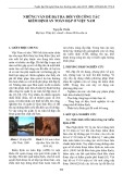
2. METHOD
2.1. Main idea of TSSFC
TSSFC consists of 3 following steps:
Step 1. (FCM for labeled data)
Split the original data points into clusters by
new weights based on unlabeled and labeled
neighborhoods using the improved FCM
algorithm.
Step 2. (Data transformation process)
To determine the membership levels of
unlabeled data points it is necessary to use the
cluster centers obtained in Step 1. The values of
membership in both unlabeled and labeled data
will pro
duce
the
previous membership
qualifications
(Ū) for
the
next
step.
JSTT 2022, 2 (3), 33-41
Pham & et al
35
Step 3. (Semi supervised fuzzy clustering
with multiple point fuzzifiers)
It is necessary to use a semi-supervised
fuzzy clustering algorithm with multiple fuzzifiers
to control the data clustering process.
The framework of
TSSFC
algorithm is
given in Figure 1
as follows.
Figure 1. The flowchart of TSSFC algorithm
2.2. Details of the TSSFC
2.2.1. Step 1 (FCM for labeled data)
In this step, the algorithm compares the
labeled data elements to identify the data elements
with low and high confidence. To do this, we
change the original FCM algorithm with the new
objective as follows
2
12
11 31
LC
m
kk
ki ki
ki k
nn
J u d Min
n
==
+
=→
+
(1)
u
ki
∈
[0, 1]; i
=
1, ..., C; k
=
1, ..., L
(2)
∑uki
C
i=1
=1 ; k =1,...,L
(3)
Where
3k
n
is the number of neighbors with
different label to
k
x
;
2k
n
is the number of neighbors
with the same label to
k
x
;
1k
n
is the number of
unlabeled data neighbors.
These neighbors are
defined based on the radius R and are
determined using the Euclidean distance. The
value of R is calculated as (d
max
− d
min
) /10 where
d
min
, d
max
are the minimum and maximum
distance between two universal data points. The
symbols C, L and d
ki
are the number of clusters,
expressed for the amount of labeled data, and
the distance between i
th
cluster center and k
th
data point.
Applying Lagrange method, the
membership values and cluster center of the
optimization problem (17-19) are specified as
below.
12
13
12
13
1; 1,..,
1
L
m
kk
ki k
kk
iL
m
kk
ki
kk
nn
uX
n
V i C
nn
u
n
=
=
+
+
==
+
+
(4)
2
1
1
1; 1,.., , 1,..,
ki
m
C
ki
jkj
u k L i C
d
d
−
=
= = =
(5)
When dealing with incorrectly labeled data,
we use defuzzification to reduce its membership
value. If the assigned cluster is different from the
data point's label, then the uik membership value is
correspondingly reduced according to equation (6).
2
if labelof cluster is same to label of
2( 1)
if and labelof cluster
is same to label of
ki
k
kj
ki
ki
k
u
ix
u
uuC
i j j
x
=+
−
(6)
The data point is labeled with small impact,
or is set to a very low membership value, or is
removed from the labeled data set. The modified
FCM algorithm is described in Algorithm 1 below.
Algorithm 1. The modified FCM algorithm
Input
:
Data set X with number of elements (N) in

JSTT 2022, 2 (3), 33-41
Pham & et al
36
d
dimensions, the number of labeled data in
X
:
LN
; threshold
; fuzzifier
m
; the number of
clusters: (
C
); exponent
and
MaxStep is
the
maximal number of iteration.
Output
: Membership matrices u and cluster
centers V.
BEGIN
1
: Set t = 0
2
: Initialize original cluster centers:
()t
i
V
← random;
i
=
1, . . ., C
//Repeat
3-7
:
3
: t = t + 1
4
: Calculate
()t
ki
u
for labeled data (k = 1, ..., L; i
= 1, ..., C) by (5).
5
: Defuzzied
()t
ki
u
according to (6).
6
: Calculate
()t
i
V
(i = 1, ..., C) using (4).
7
: Check the stop condition:
( ) ( )
1tt
ii
VV
−
−
or t >
MaxStep. If this condition is satisfied, the
algorithm is stop. Otherwise, return
3
.
END
2.2.2. Step 2 (Data transformation)
This is the transfer step between Step 1
and Step 3 (below). From the output of Step 1, we
collect the cluster centers V of the labeled data.
Unlabeled data points will use the result just
obtained as the initial cluster center. Membership
values of both unlabeled and labeled data will
generate previous membership qualifications
(Ū)
for
the
metho
d
in
next
step.
Thus, in our
implementation, the mixture of the prior
membership levels (Ū) and the labeled data is the
predefined information of the semi-supervised
fuzzy clustering.
2.2.3. Step 3 (Multiple point fuzzifiers for semi-
supervised fuzzy clustering algorithm)
Based on the previous membership values
(Ū), we set up the objective function of TSSFC for
all data points of TSSFC as follows:
JTSSFC=∑∑uki
2dki
2
C
i=1
N
k=1
+λ ∑∑(uki-uki)2dki
2
C
i=1
N
k=1
→Min
(7)
with the constraints:
uki∈[0,1],i=1,...,C ; k =1,...,L
(8)
1
1; 1,...,
C
ki
i
u k L
=
==
(9)
By using Lagrange and Gradient descent
methods below, these problems will be solved:
( )
( )
( )
( )
2
2
1
2
2
1
;
1,...,
N
ki ki ki k
k
iN
ki ki ki
k
u u u X
V
u u u
iC
=
=
+−
=
+−
=
(10)
( )
1
2
1
1
;
1
1
1,..., , 1,...,
C
kj
jki
ki C
ki
jkj
uu
u
d
d
k N i C
=
=
+−
=−
+
+
==
(11)
The TSSFC algorithm is shown in Algorithm
2. In our implementation, the entire dataset with the
initial membership (Ū) will be partitioned using the
TSSFC model described in the 2nd block.
Algorithm 2. Semi-supervised fuzzy clustering
algorithm
Input: Data set 𝑋 with number of elements (N) in
d
dimensions, the number of labeled data in
X
:
LN
; fuzzifier
m
; threshold
; the number of
clusters: (
C
); exponent
and
MaxStep
is the
maximal number of iteration; the previous
membership values for all data points (Ū).
Output: Final membership matrices
u
and cluster
centers
V
BEGIN
Step 1: Initialize the iteration:
=0t
Step 2: Repeat the following steps 3-6:
Step 3:
=+1tt
Step 4: Calculate
()t
ki
u
(i=1,...,C; k=1,...,N)
by equation (11).
Step 5: Calculate
()t
i
V
(i=1,...,C) by equation (10).
Step 6: Check the stopping conditions:
( ) ( )
1tt
ii
VV
−
−
or t >
MaxStep
. If satisfied then
stop.
END
JSTT 2022, 2 (3), 33-41
Pham & et al
37
2.3. Remarks
- Complexity Analysis: There are two
separate loops in the introduced method. In the
first, the labeled data is partitioned using FCM, then
its complexity is approx.
( )
2
1
O steps LC
, where
1
steps
was the number of the first loop. In the last
one, all datasets are clustered using TSSFC then
the complexity is about
( )
2
2
O steps NC
.
Obviously, L << N, then usually
21
steps steps
.
The complexity of the introduced
TSSFC
method
is
( )
2
2
O steps NC
compared to
( )
2
O steps NLC
of
CS3FCM. Therefore,
TSSFC
is better in terms of
time calculation.
- Advantages of the TSSFC algorithm:
The introduced algorithm can be better in
terms of computation time than other safe semi-
supervised fuzzy clustering methods. For
clustering, the algorithm performs two steps. The
first step performs a labeled data partition to
compute the initial membership of all the data in the
second step. The last one is modified based on the
semi-supervised FCM, then less complex than
other algorithms when partitioning the whole data.
By eliminating or reducing the influence of
data points labeled as suspicious, TSSFC can
provide better clustering quality than other safe
semi-supervised fuzzy clustering methods.
- Disadvantages of the TSSFC algorithm:
a) In the first step, the FCM algorithm may
have to perform more iterations when performing
the membership values reduction of the data
labeled with doubt.
b) Given the diverse distribution of data
points, it is difficult to accurately calculate the
radius to determine the neighbors of labeled data.
The first step becomes more complicated the
larger the radius.
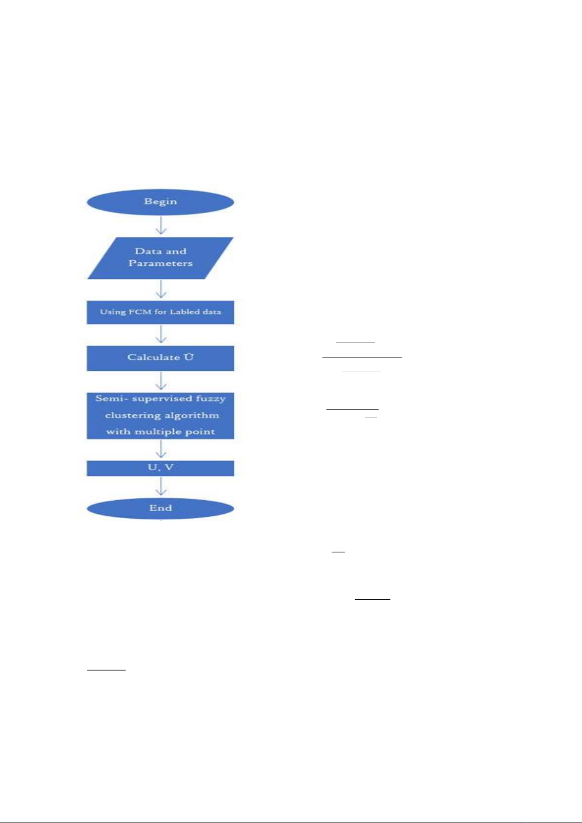
3. RESULTS
3.1. Environment setting
CS3FCM and
TSSFC
algorithms are
implemented on Lenovo laptop with Core i7
processor, using DevC++ IDE.
The dataset is provided by Faculty of
Water Resources Engineering - Thuy Loi
University which is satellite image of the Cua Dai
riverbank area, Quang Nam province, Vietnam.
The original size of the satellite image is 7651 x
7811 pixels. The original format of satellite
images was TIFF images. These images will be
converted to PNG image format for further
processing.
Figure 2. The origin satellite image
For processing convenience, we rotate the
image along the vertical axis by an angle of 13
degrees. Then, we split the image obtained from
the previous step into smaller images of size
201x201 pixcels
using the InterArea
interpolation
supported in the OpenCV image
processing library for the convenience of
algorithm implementation. Some images after
splitting as shown below.
From satellite images, we use cvat.org to
locate pixels containing landslides. Landslide
areas are areas where cracks appear in the soil
surface. The landslide areas will be marked with
different colors.
The number of attributes is reduced by
converting the RGB to a grayscale image. Using
a 3x3 sliding window to scan the surface of the
image, the obtained results are used to
synthesize the result of attributes in images. The
properties are saved to a text file that will be
used as input to the algorithm program. In the