ĐÁNH GIÁ SỰ BIẾN ĐỘNG ĐẤT MẶN VÀ ĐẤT PHÈN VÙNG ĐỒNG
BẰNG SÔNG CỬU LONG SAU 30 NĂM SỬ DỤNG
Hồ Quang Đức
1
, Nguyễn Văn Đạo
1
SUMMARY
Evaluating the changes of saline soils and acid sulfate soils in the Cuu Long river delta
after 30 years of using
Saline soils and acid sulfate soils are the main soil types in the Cuu Long River Delta which play
an important role for rice production in the delta as well as in Vietnam. Under the influences of
climate changes, land use and others, saline soils and acid sulfate soils in the delta have been
changing in both area and quality. Our survey for these soils in Cuu Long River Delta in 2005
showed that total area of the saline soils increased 177,714.5 ha compared to the data of
previous survey in 1975; of which the areas of the strongly saline soil and the moderately and
slightly saline soil increased 26,744.7 ha and 199,757.1 ha respectively, while the total area of
mangrove saline soil decreased 48,787.3 ha. Total area of the acid sulfate soils decreased
261,590.7 ha compared to the data of the survey in 1975; of which the potential acid sulfate soil
decreased 594,880.6 ha, while the actual acid sulfate soil increased 333,289.8 ha. By comparing
the soil analysis data from the survey in 1975 and from our survey in 2005, we found that the
quality of these soils was significant change after 30 years of using. The particle sizes were
slightly changed, especially in the top soil layers because of influences of water regime. The pH
value of the acid sulfate soils decreased in the most of soil samples. The total nutrient contents
such as organic carbon, nitrogen, phosphorus and potassium slightly changed in most saline soil
samples, but significantly decreased in acid sulfate soil samples, especially for organic carbon
and total nitrogen. The available nutrient such as phosphorus, potassium, calcium, and
magnesium slightly decreased in both saline and acid sulfate soils.
Keywords: saline soil, acid sulfate sois, Cuu Long River Delta.
I. §ÆT VÊN §Ò
Đồng bằng sông Cửu Long (ĐBSCL) là
vùng châu thổ lớn nhất của nước ta, có tổng
diện tích tự nhiên (DTTN) khoảng 40.602
km², chiếm 12,3% diện tích toàn quốc; là
vùng kinh tế có vai trò quan trọng trong quá
trình phát triển của cả nước. Đất đai nơi đây
về bản chất chủ yếu là đất phù sa. Tuy
nhiên do chịu tác động của thủy triều, rừng
ngập mặn đã hình thành nên nhóm đất mặn
và đất phèn với diện tích khoảng 2,4 triệu
ha (Chiếm 59,5% DTTN).
Qua nhiều năm khai thác và sử dụng
làm cho diện tích cũng như tính chất của
đất mặn và đất phèn đã có sự biến động
đáng kể. Vì vậy, việc đánh giá sự biến động
cả về số lượng và chất lượng của đất mặn
và đất phèn cần được quan tâm để kịp thời
nhằm đưa ra các giải pháp khai thác và sử
dụng hợp lý, có hiệu quả.
II. VËT LIÖU Vµ PH¦¥NG PH¸P NGHI£N CøU
1. Vật liệu nghiên cứu
Gồm 13 tỉnh có đất mặn, đất phèn ở
ĐBSCL: Long An, Tiền Giang, Bến Tre,
1
Viện Thổ nhưỡng Nông hoá
Đồng Tháp, Vĩnh Long, Trà Vinh, Hậu
Giang, Sóc Trăng, An Giang, Kiên Giang,
Bạc Liêu, Cà Mau và TP. Cần Thơ trên bản
đồ tỷ lệ 1/100.000, sau đó tổng hợp lên toàn
vùng ĐBSCL ở tỷ lệ 1/250.000. Tổng số
phẫu diện thu thập là 4.937 phẫu diện, trong
đó có 397 phẫu diện chính và 4.540 phẫu
diện phụ. Phẫu diện đất được lấy theo hình
“rẻ quạt”, tức là lấy dày lên từ tâm ranh giới
đất mặn và đất phèn ra phía ngoài ranh giới
các loại đất khác.
2. Phương pháp nghiên cứu
Phương pháp phân tích dựa theo Tiêu
chuNn N gành và phương pháp trình bày
trong “Sổ tay phân tích đất, nước và phân
bón” của Viện Thổ nhưỡng Nông hóa
(1998). Các chỉ tiêu phân tích đất bao gồm:
pHH
2
O và pHKCl; thành phần cấp hạt; các
bon hữu cơ (OC), N, P, K tổng số; P, K dễ
tiêu; Ca
2+
, Mg
2+
trao đổi; độ dẫn điện (EC);
tổng số muối tan (TSMT); Clo tổng số (Cl
-
);
SO
32-
tổng số, SO
42-
hòa tan; Fe tổng số,
Fe
3+
, Al
3+
hòa tan.
Phân loại đất theo phương pháp phân
loại của Việt Nam áp dụng cho bản đồ tỷ lệ
trung bình. Thống nhất cách gọi tên đất để
thuận lợi khi so sánh biến động. Đồng thời
bản đồ đất của hai thời kỳ cũng được thống
nhất chỉnh lý vào hệ tọa độ VN2000 để tiện
so sánh.
III. KÕT QU¶ Vµ TH¶O LUËN
1. Biến động về diện tích
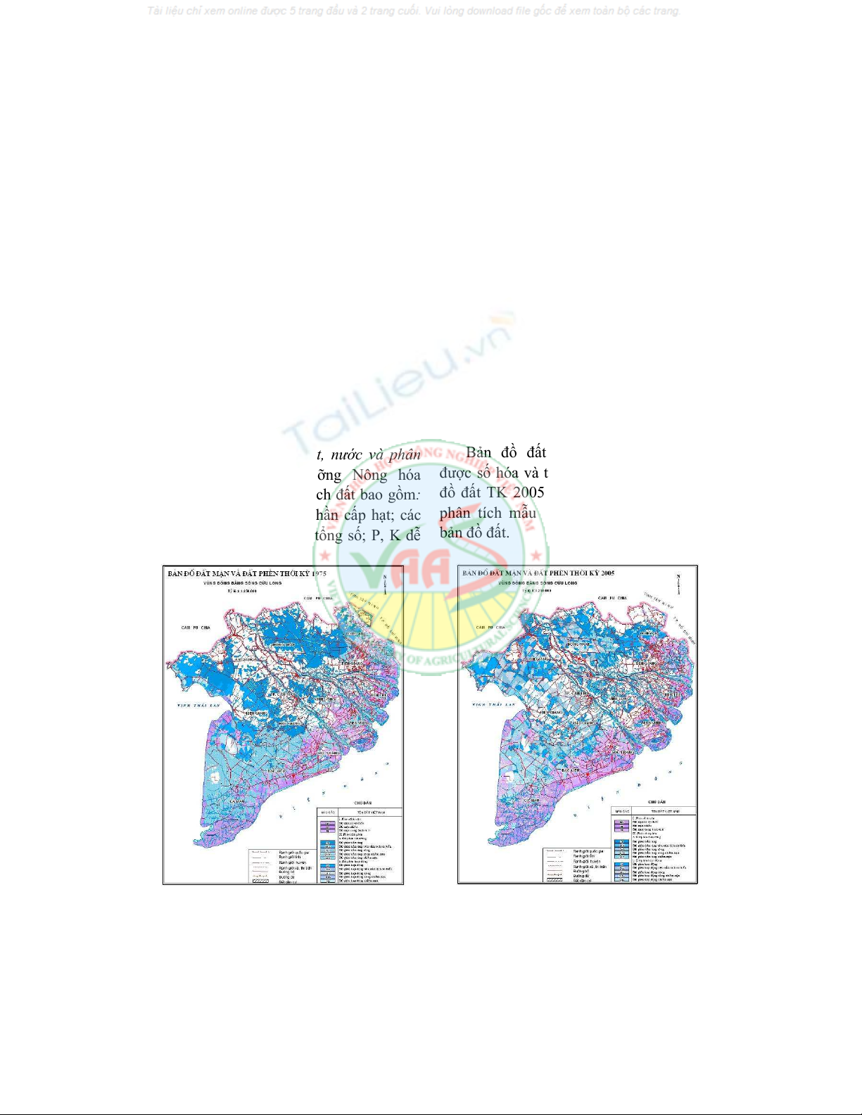
Bản đồ đất vùng ĐBSCL TK 1975
được số hóa và thống kê diện tích, còn bản
đồ đất TK 2005 được xây dựng trên cơ sở
phân tích mẫu đất, phân loại và chỉnh lý
bản đồ đất.
Hình 1. Bản đồ đất mặn và đất phèn TK1975
Hình 2. Bản đồ đất mặn và đất phèn TK2005
Sau khi xây dựng được bản đồ đất,
dùng phần mềm Mapinfo và Excel để thống
kê và so sánh biến động diện tích giữa hai
thời kỳ. Kết quả thể hiện ở bảng 1.
Bảng 1. Biến động diện tích đất mặn và đất phèn vùng ĐBSCL qua các thời kỳ
Tên đất Diện tích đất mặn, đất phèn qua các thời kỳ (ha) Biến động diện tích (ha)
TK 1975 % TK 2005 % 2005 - 1975
I. Nhóm đất mặn 706.485,2 28,26 884.199,7 36,60 +177.714,5
1. Đất mặn sú, vẹt, đước 168.697,9 6,75 119.910,6 4,96 -48.787,3
2. Đất mặn nhiều 256.830,1 10,27 283.574,8 11,74 +26.744,7
3. Đất mặn TB và ít 280.957,2 11,24 480.714,3 19,90 +199.757,1
II. Nhóm đất phèn 1.793.119,3
71,74 1.531.528,6
63,40 -261.590,7
4. Đất phèn tiềm tàng 1.513.173,3
60,54 918.292,7 38,01 -594.880,6
5. Đất phèn hoạt động 279.946,0 11,20 613.235,9 25,39 +333.289,8
Tổng diện tích: 2.499.604,5
100,00 2.415.728,3
100,00 -83.876,2
Qua số liệu Bảng 1 cho thấy: Đất mặn
sú, vẹt, đước giảm 48.787,3 ha; chủ yếu do
chuyển sang các loại đất phi nông nghiệp
khác: Nuôi trồng thủy sản, thủy lợi, đất ở.
Ngoài ra một phần diện tích chuyển sang
đất mặn nhiều (khoảng 11%) và đất phèn
(khoảng 2%). Đất mặn nhiều tăng lên
26.744,7 ha do đất mặn sú vẹt đước và đất
phèn tiềm tàng chuyển sang.
Biến động lớn nhất là đất mặn trung
bình và ít và đất phèn hoạt động. Trong
những năm qua ở ĐBSCL việc tái nhiễm
mặn đã trở nên phổ biến, đặc biệt vào giữa
mùa khô khi nước sông đầu nguồn cạn dần,
nước mặn từ biển theo các cửa sông tràn
sâu vào trong đất liền có nơi tới 50km (Bến
Tre) gây ra tình trạng tái nhiễm mặn, như ở
các tỉnh Bến Tre, Tiền Giang, Vĩnh Long,
Hậu Giang. Diện tích đất tái nhiễm mặn
chiếm khoảng 46% tổng diện tích đất mặn.
Tuy nhiên nhiều vùng đất mặn trung bình
và ít qua quá trình cải tạo và sử dụng hợp lý
đã trở thành đất phù sa như ở Long An,
Tiền Giang, Bến Tre, Trà Vinh, Sóc Trăng.
Ngoài ra một phần diện tích đất nằm gần
các cửa sông: Cửa Tiểu, cửa Đại, cửa Hàm
Luông, Cổ Chiên, Định An, Tranh Đề... đã
bị mặn xâm nhập, làm tăng diện tích đất
mặn trung bình và ít.
Việc đáng lưu ý nhất là diện tích đất
phèn hoạt động tăng mạnh (Tăng
333.289,84 ha), chủ yếu do đất phèn tiềm
tàng chuyển sang (khoảng 36%). Chứng
tỏ công tác cải tạo đất phèn chưa mang lại
nhiều hiệu quả, điển hình tình trạng này
đã diễn ra là ở các tỉnh Long An, Đồng
Tháp, Tiền Giang, Kiên Giang, An Giang
và Cà Mau.
2. Biến động về tính chất đất đai
2.1. Biến động tính chất đất mặn
Trong nhóm đất mặn thì đất mặn sú,
vẹt, đước ít có sự biến động về tính chất
nhất, do hầu hết diện tích được khoanh nuôi
trồng rừng ngập mặn. Sự tác động bên
ngoài chủ yếu do bồi đắp phù sa hàng năm
nên có chút thay đổi về cấp hạt cát ở tầng
mặt. Ngoài ra hàm lượng một số chất dinh
dưỡng như đạm, lân và đặc biệt kali có sự
tăng lên. Tuy nhiên mức độ thay đổi không
nhiều.
Qua số liệu Bảng 2 cho thấy: Đất mặn
nhiều cũng ít có sự biến động về độ mặn
(độ dẫn điện và tổng số muối tan ít biến
động). Hàm lượng Cl
-
giảm 0,53%, do quá
trình thau chua, rửa mặn làm giảm lượng
muối trong đất nên hàm lượng Clo cũng
giảm. Thành phần cấp hạt tăng lên ở cấp hạt
cát và thịt, còn cấp hạt sét giảm. Hầu hết
hàm lượng dinh dưỡng các chất tổng số đều
tăng lên so với trước đây, tuy nhiên sự tăng
đó là không đáng kể. Lân dễ tiêu có biến
động không nhiều. Hàm lượng kali dễ tiêu
tăng 2,87 mg/100 g đất. Hàm lượng Ca
2+
và
Mg
2+
tăng lên, tương ứng dung tích hấp thu
cũng tăng lên 2,10 me/100 g đất.
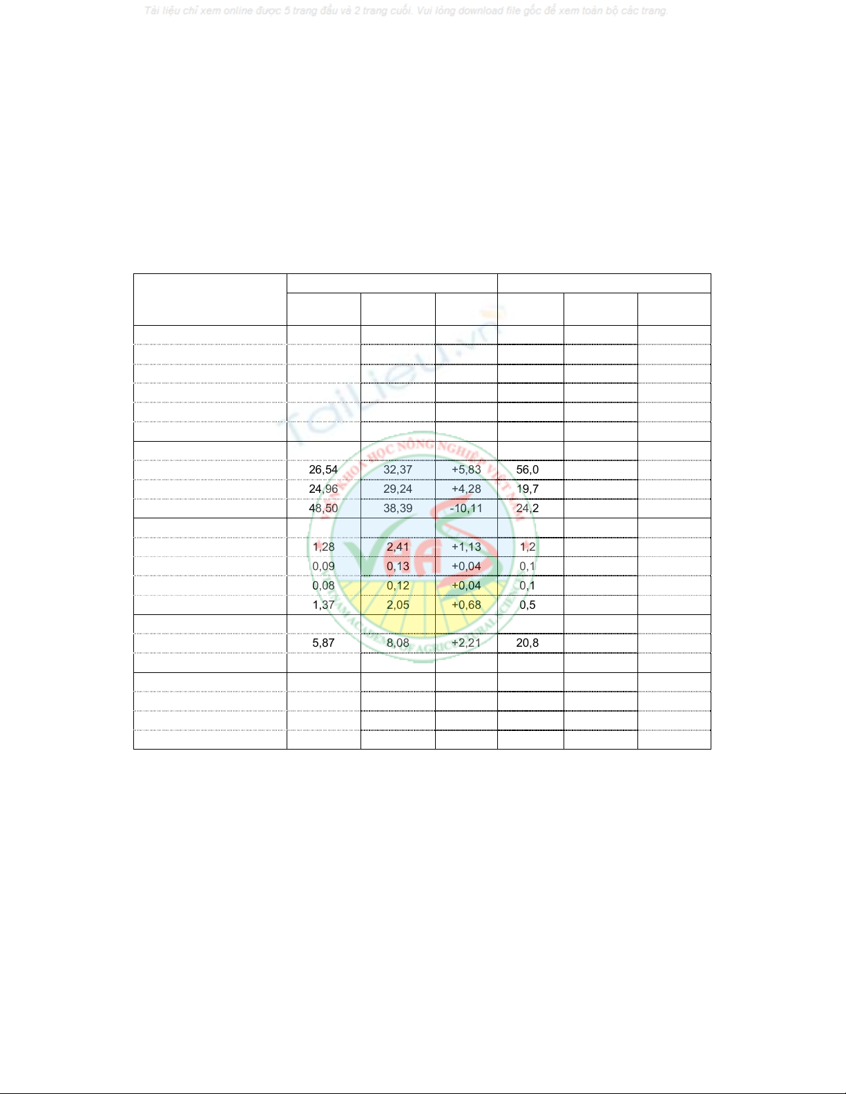
Bảng 2. Biến động một số chỉ tiêu chất lượng đất mặn vùng ĐBSCL
n: Số mẫu
Chỉ tiêu so sánh
(Tính trung bình
cho toàn vùng)
Đất mặn nhiều Đất mặn trung bình và ít
TK1975
(n=60)
TK2005
(n=140)
Biến
động
TK1975
(n=80)
TK2005
(n=250) Biến động
1. Tính chất mặn:
pHH
2
O 7,20 6,53 -1,17 6,09 6,32 +0,23
pHKCl 5,80 5,89 +0,09 5,27 5,39 +0,12
EC (mS/cm) 4,42 4,42 0,00 0,75 1,59 +0,84
TSMT (%) 1,83 1,82 +0,01 0,46 0,55 +0,09
Cl
-
(%) 1,18 0,65 -0,53 0,06 0,20 +0,14
2. Thành phần cấp hạt:
Cát (%) 26,54 32,37 +5,83 56,05 31,19 -24,86
Thịt (%) 24,96 29,24 +4,28 19,70 29,16 +9,46
Sét (%) 48,50 38,39 -10,11 24,25 39,65 +15,40
3. Các chất tổng số:
OC (%) 1,28 2,41 +1,13 1,27 1,55 +0,28
Nts (%) 0,09 0,13 +0,04 0,11 0,11 0,00
P
2
O
5
ts (%) 0,08 0,12 +0,04 0,12 0,08 -0,04
K
2
Ots (%) 1,37 2,05 +0,68 0,56 1,94 +1,38
4. Các chất dễ tiêu:
P
2
O
5
dt (mg/100g đất) 5,87 8,08 +2,21 20,84 4,42 -16,42
K
2
Odt (mg/100g đất) 70,02 72,89 +2,87 55,64 49,49 -6,15
5. Cation trao đổi:
Ca
2+
(ldl/100g đất) 1,73 2,04 +0,31 4,20 2,29 -1,91
Mg
2+
(ldl/100g đất) 3,62 4,09 +0,47 5,44 3,51 -1,93
CEC (ldl/100g đất) 15,64 17,74 +2,10 22,18 16,03 -6,15
Đối với mặn của đất mặn trung bình và
ít, các chỉ tiêu về độ mặn tăng lên qua quá
trình sử dụng. Cụ thể: EC tăng 0,84 mS/cm,
tổng số muối tan tăng 0,09% và hàm lượng
Clo cũng tăng 0,14%. Các chỉ số độ mặn
tăng lên do sự biến đổi thất thường của thời
tiết. Những năm lũ lụt nước biển dâng làm
cho các vùng ven biển bị ngập mặn, hoặc có
những năm hạn hán liên tục xảy ra, làm cho
mạch nước ngầm hoạt động mạnh, muối có
điều kiện theo các mao quản leo lên các
tầng đất phía trên. Ngoài ra vào mùa khô
khi mực nước sông Cửu Long giảm làm cho
nước biển theo sông và các kênh rạch tràn
sâu vào trong đất liền làm tăng độ mặn hoặc
gây tái nhiễm mặn cho các vùng đất. Khi độ
mặn tăng kéo theo độ chua giảm (pH tăng)
qua quá trình sử dụng.
Hàm lượng các chất tổng số: Cacbon
hữu cơ, đạm, lân tổng số trong đất mặn
trung bình và ít không có sự biến động
nhiều. Cụ thể: Hàm lượng OC tăng 0,28%;
hàm lượng N không thấy có sự biến động;
hàm lượng lân tổng số giảm 0,04%; hàm
lượng kali tổng số tăng 1,38%. Hàm lượng
lân dễ tiêu giảm 16,42 mg/100 g đất. Hàm
lượng kali dễ tiêu giảm 6,15 mg K
2
O/100g
đất. Hàm lượng Ca
2+
giảm 1,91 me/100 g
đất và Mg
2+
giảm 1,93 me/100 g đất).
Nguyên nhân do các cation bị rửa trôi
trong quá trình rửa mặn bằng biện pháp
thủy lợi.
2.2. Biến động tính chất đất phèn:
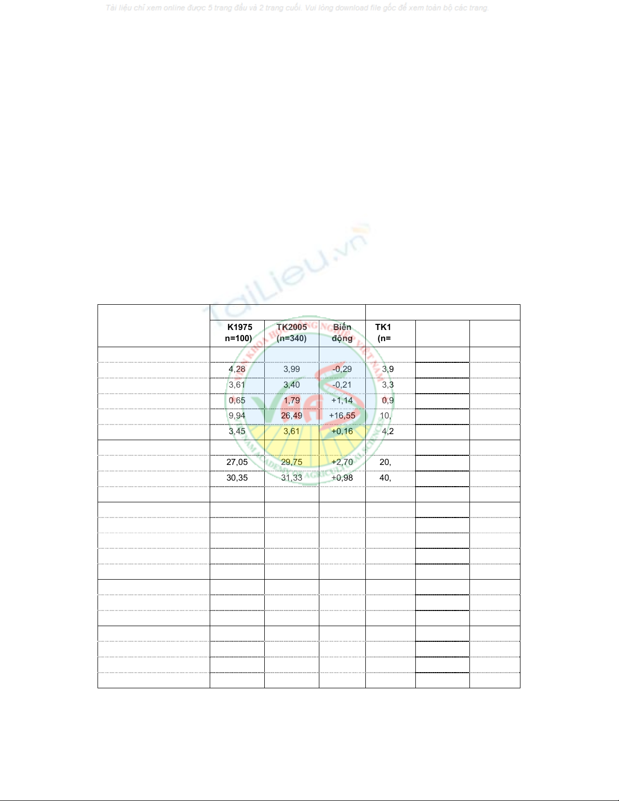
- Đất phèn tiềm tàng: Qua số liệu Bảng
3 cho thấy các tính chất phèn của đất phèn
ở ĐBSCL biến động không nhiều: Chỉ số
pHH
2
O giảm 0,29; pHKCl giảm 0,21. Hàm
lượng SO
32-
tổng số tăng 1,14%. Hàm
lượng Fe tổng số tăng 0,37%. Hàm lượng
Fe
3+
hòa tan tăng 16,55 mg/100 g đất. Hàm
lượng Al
3+
tăng lên 0,16 mg/100 g đất.
Bảng 3. Biến động một số chỉ tiêu chất lượng đất phèn vùng ĐBSCL
n: Số mẫu
Chỉ tiêu so sánh
(Tính trung bình
cho toàn vùng)
Đất phèn tiềm tàng Đất phèn hoạt động
TK1975
(n=100)
TK2005
(n=340)
Biến
động
TK1975
(n=80)
TK2005
(n=480) Biến động
1. Tính chất phèn
pHH
2
O 4,28 3,99 -0,29 3,90 3,96 +0,06
pHKCl 3,61 3,40 -0,21 3,35 3,35 0,00
SO
32-
ts (%) 0,65 1,79 +1,14 0,93 1,69 +0,76
Fe
3+
(mg/100g đất) 9,94 26,49 +16,55 10,78 42,92 +32,14
Al
3+
(mg/100g đất) 3,45 3,61 +0,16 4,28 3,24 -1,04
2. Thành phần cơ giới:
Cát (%) 27,05 29,75 +2,70 20,15 28,25 +8,10
Thịt (%) 30,35 31,33 +0,98 40,52 31,62 -8,90
Sét (%) 42,60 38,92 -3,68 39,34 40,14 +0,80
3. Các chất tổng số:
OC (%) 4,59 3,24 -1,35 3,23 2,19 -1,04
Nts (%) 0,25 0,17 -0,08 0,25 0,14 -0,11
P
2
O
5
ts (%) 0,05 0,07 +0,02 0,10 0,05 -0,05
K
2
Ots (%) 1,22 1,66 +0,44 1,34 1,69 +0,35
4. Các chất dễ tiêu:
P
2
O
5
dt (mg/100g đất) 4,84 3,63 -1,21 4,43 1,73 -2,70
K
2
Odt (mg/100g đất) 10,86 23,68 +12,82 8,80 17,76 +8,96
5. Cation trao đổi:
Ca
2+
(ldl/100g đất) 3,07 2,71 -0,36 3,69 1.79 -1,90
Mg
2+
(ldl/100g đất) 6,71 2,48 -4,23 5,85 2.34 -3,51
CEC (ldl/100g đất) 27,03 16,39 -10,64 27,12 16.85 -10,27


%20--%3e%3cdefs%3e%3cstyle%3e%20.st0%20{%20fill:%20%23fff;%20}%20.st1%20{%20fill:%20%237800fa;%20}%20%3c/style%3e%3c/defs%3e%3cpath%20class='st1'%20d='M117.78,12.18H43.11c2.9,3.47,4.65,7.94,4.65,12.82,0,5.6-2.3,10.66-6.01,14.29h76.02l7.22-13.56-7.22-13.56Z'/%3e%3cg%3e%3cpath%20class='st0'%20d='M53.58,26.17h-.59v-1.46h.59v-4.96h2.83c1.78,0,2.67.94,2.67,2.82v5.76c0,1.87-.89,2.81-2.67,2.81h-2.83v-4.96ZM55.36,21.37v3.34h1.1v1.46h-1.1v3.34h1.01c.61,0,.91-.37.91-1.1v-5.93c0-.74-.3-1.1-.91-1.1h-1.01Z'/%3e%3cpath%20class='st0'%20d='M65.99,31.14h-1.8l-.31-2.07h-2.19l-.31,2.07h-1.64l1.82-11.39h2.62l1.82,11.39ZM65.28,18.04c-.25.46-.51.77-.75.94-.21.15-.47.22-.79.22-.26,0-.57-.07-.92-.22l-.38-.15c-.14-.05-.26-.07-.37-.07-.3,0-.53.18-.71.54l-.91-.68c.25-.46.51-.77.75-.94.21-.14.48-.21.79-.21.26,0,.57.07.92.21l.38.15c.14.05.26.07.37.07.3,0,.53-.18.71-.54l.91.68ZM61.91,27.52h1.73l-.87-5.76-.87,5.76Z'/%3e%3cpath%20class='st0'%20d='M74.53,26.89v1.52c0,1.91-.89,2.86-2.67,2.86s-2.67-.95-2.67-2.86v-5.93c0-1.91.89-2.86,2.67-2.86s2.67.95,2.67,2.86v1.11h-1.69v-1.22c0-.75-.31-1.12-.93-1.12s-.93.37-.93,1.12v6.15c0,.74.31,1.11.93,1.11s.93-.37.93-1.11v-1.63h1.69Z'/%3e%3cpath%20class='st0'%20d='M81.4,31.14h-1.8l-.31-2.07h-2.19l-.31,2.07h-1.64l1.82-11.39h2.62l1.82,11.39ZM75.9,19.2l1.52-1.91h1.71l1.51,1.91h-1.61l-.76-.95-.75.95h-1.61ZM77.32,27.52h1.73l-.87-5.76-.87,5.76ZM83.1,15.99l-1.76,1.91h-1.26l1.17-1.91h1.86Z'/%3e%3cpath%20class='st0'%20d='M84.86,19.75c1.78,0,2.67.94,2.67,2.82v1.48c0,1.87-.89,2.81-2.67,2.81h-.85v4.28h-1.79v-11.39h2.64ZM84.01,21.37v3.86h.85c.58,0,.87-.36.87-1.08v-1.71c0-.71-.29-1.07-.87-1.07h-.85Z'/%3e%3cpath%20class='st0'%20d='M93.51,19.75c1.78,0,2.67.94,2.67,2.82v1.48c0,1.87-.89,2.81-2.67,2.81h-.85v4.28h-1.79v-11.39h2.64ZM92.66,21.37v3.86h.85c.58,0,.87-.36.87-1.08v-1.71c0-.71-.29-1.07-.87-1.07h-.85Z'/%3e%3cpath%20class='st0'%20d='M98.8,31.14h-1.79v-11.39h1.79v4.88h2.03v-4.88h1.83v11.39h-1.83v-4.88h-2.03v4.88Z'/%3e%3cpath%20class='st0'%20d='M105.36,24.55h2.46v1.62h-2.46v3.34h3.09v1.63h-4.88v-11.39h4.88v1.63h-3.09v3.18ZM108.17,17.29l-1.76,1.91h-1.26l1.17-1.91h1.86Z'/%3e%3cpath%20class='st0'%20d='M112.2,19.75c1.78,0,2.67.94,2.67,2.82v1.48c0,1.87-.89,2.81-2.67,2.81h-.85v4.28h-1.79v-11.39h2.64ZM111.35,21.37v3.86h.85c.58,0,.87-.36.87-1.08v-1.71c0-.71-.29-1.07-.87-1.07h-.85Z'/%3e%3c/g%3e%3ccircle%20class='st1'%20cx='25'%20cy='25'%20r='20'/%3e%3cpath%20class='st0'%20d='M32.78,19.27c2.92,0,4.43,2.55,5.28,5.33l.71,2.17c.14.38-.33.75-.71.75h-5.61c.19-.33.24-.71.09-1.08l-.75-2.45c-.43-1.32-.99-2.64-1.79-3.77.75-.57,1.65-.94,2.78-.94h0ZM25,18.38c3.25,0,4.9,2.78,5.89,5.89l.76,2.45c.14.42-.33.8-.8.8h-11.69c-.42,0-.94-.38-.8-.8l.75-2.45c.99-3.11,2.64-5.89,5.89-5.89h0ZM25,11.35c1.74,0,3.11,1.37,3.11,3.11s-1.37,3.11-3.11,3.11-3.11-1.41-3.11-3.11,1.41-3.11,3.11-3.11h0ZM17.27,19.27c1.08,0,1.98.38,2.73.94-.8,1.13-1.37,2.45-1.74,3.77l-.8,2.45c-.14.38-.05.75.09,1.08h-5.56c-.42,0-.9-.38-.75-.75l.71-2.17c.9-2.78,2.41-5.33,5.33-5.33h0ZM17.27,12.91c1.51,0,2.78,1.27,2.78,2.83s-1.27,2.83-2.78,2.83-2.83-1.27-2.83-2.83,1.27-2.83,2.83-2.83h0ZM32.78,12.91c1.56,0,2.78,1.27,2.78,2.83s-1.23,2.83-2.78,2.83-2.83-1.27-2.83-2.83,1.27-2.83,2.83-2.83h0ZM27.07,28.56v.09c0,.57-.24,1.08-.61,1.46h0v.05c-.38.33-.9.57-1.46.57s-1.08-.24-1.46-.61h0c-.38-.38-.61-.9-.61-1.46v-.09h1.41v.09c0,.19.05.38.19.47v.05c.09.09.28.19.47.19s.38-.09.47-.19v-.05c.14-.09.24-.28.24-.47t-.05-.09h1.41ZM30.99,28.56v.09c0,1.65-.66,3.16-1.74,4.24-1.08,1.08-2.59,1.79-4.24,1.79s-3.16-.71-4.24-1.79l-.05-.05c-1.04-1.08-1.7-2.55-1.7-4.2v-.09h1.41v.09c0,1.27.47,2.4,1.27,3.25h.05c.85.85,1.98,1.37,3.25,1.37s2.4-.52,3.25-1.37c.85-.8,1.37-1.98,1.37-3.25v-.09h1.37ZM34.99,28.56v.09c0,2.78-1.13,5.28-2.92,7.07-1.79,1.79-4.29,2.92-7.07,2.92s-5.23-1.13-7.07-2.92c-1.79-1.79-2.92-4.29-2.92-7.07v-.09h1.41v.09c0,2.4.94,4.53,2.5,6.08,1.56,1.56,3.72,2.5,6.08,2.5s4.52-.94,6.08-2.5c1.56-1.56,2.5-3.68,2.5-6.08v-.09h1.41Z'/%3e%3c/svg%3e)