ISSN 1859-1531 - THE UNIVERSITY OF DANANG - JOURNAL OF SCIENCE AND TECHNOLOGY, VOL. 22, NO. 11C, 2024 123
WATERSCAPES: THE CULTURAL HERITAGE FOR SUSTAINABLE
DEVELOPMENT IN THE URBAN STRUCTURE OF HUE CITY IN VIETNAM
Vo Ngoc Duc*
University of Sciences, Hue University, Vietnam
*Corresponding author: vngocduc@hueuni.edu.vn
(Received: September 08, 2024; Revised: September 27, 2024; Accepted: October 09, 2024)
DOI: 10.31130/ud-jst.2024.570E
Abstract - For many years, waterscapes have used as
indispensable architectural elements in urban design like
Amsterdam, Venice, etc. Similarly, from 1802 to 1945, the
integration of water into the layout of Hue city exemplified
sustainable urban planning. Additionally, Feng Shui method
positions water as a crucial component Hue city which represents
a unique harmony between humans and nature, reflecting Eastern
philosophical ideas and traditional Vietnamese architecture. The
waterway model was seamlessly integrated with the waterscape
and monuments, establishing the unique identity for the local
ecosystem. In recent decades, Hue’s waterscape has undergone
considerable change due to urbanization, environmental pollution,
flooding, and disruption of water flow. These factors have altered
the characteristics of traditional waterscape and negatively
affected the previous concept of water system. Identifying the
characteristics and values of the traditional water network is as
cultural heritage to preserve and promote a sustainable model that
adapts with local environmental self-regulating technology.
Key words - Waterscape; Identity; Feng Shui; Hue city;
Sustainability.
1. Introduction
For a long time, people have used the water as an
indispensable element for life such as drinking, washing,
main transportation and mental element, their needs were
interesting in the urban environment with the
enhancement in living conditions and enjoying the art so
that the water in urban planning had attracted more
attention, and the living spaces with water elements have
become more popular. This longstanding interest in water
is evident in the way civilizations historically established
their settlements near rivers, streams, lakes, lagoons, and
other water resources [1].
The water has been the basic element in urban
planning of Venice, Amsterdam, Suzhou... Water is used
to create the specific identity of the local places (Figure 1
and 2). The visual form and function of the water is
interesting in their planning. They relate to the
movements, form and models of water and its endless
transformation from sources to the sea [1]. Water is also
an important element that can be related in the landscape
design and it is a unique material in terms of landscape
design [2]. The water element in open spaces has a
relevant value because of its aesthetic value, sensory
stimulant, social function and psychological benefits for
landscape architects, environmental designers, and for the
community [3]. The various concepts and practices related
to waterscapes from Vietnam, Thailand, Cambodia, and
Indonesia, with the majority at the Southeast Asian
Geography Association (SEAGA, http://www.seaga.info/)
2014 [4]. Cultural differences, climatic and topographic
conditions have been the elements which have diversified
the use of water. The use of water elements in design and
urban planning has evolved over time, influenced by
various cultures that have impacted one another. This
influence continues today, with new trends sustaining and
reshaping these traditional styles [1].
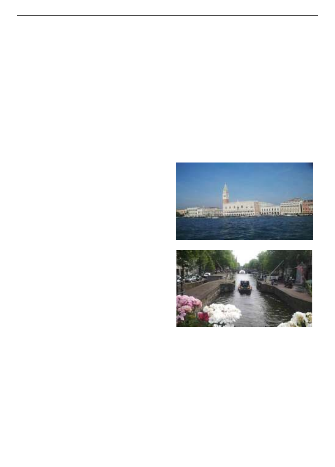
Figure 1. Waterscape in Venice, Italy (source: the author)
Figure 2. Waterscape in Amsterdam, Netherlands
(source: the author)
In Hue city of Vietnam, waterscape was applied as an
indispensable element for urban design by the Nguyen
Dynasty. During the period of urban construction from
1802 to 1945, the integration of water elements with Hue
city served as an exemplary model of sustainable urban
planning. Furthermore, Feng Shui method emphasizes the
importance of water as a vital component in urban design.
For instance, the waterscape of Hue city embodies a
unique unification of human and nature, reflecting Eastern
philosophical ideas and traditional Vietnamese
architecture [5]. The waterway model was seamlessly
integrated with monuments and the surrounding
waterscape, contributing to the unique identity of the local
ecological system. While numerous studies have explored
124 Vo Ngoc Duc
the influence of Vietnamese researchers, as well as
scholars from Japan, Italy, and France, there has not yet
been a full assessment of the role of water and the value
of waterscapes within the urban structures established by
earlier generations. Additionally, the significance of the
integration of urban design with natural water elements
have not been identified.
2. Materials and method
2.1. Ecological method
Hue's urban planning effectively utilized natural
resources and the tropical climate to develop a proper
living environment. It is important to understand the
formation of the Hue Citadel, ideas and geography’s
condition behind its construction. The urban structure is
closely tied to the local topography and water resources.
Ecological technology is properly adapted to local
geography, wind and water. The ecological value derived
from system features of the urban structure, functions and
components of the ecosystem.
2.2. Feng Shui method
The distinctive character of ancient Vietnamese cities
was rooted in Eastern philosophy. Utilizing available
natural elements, Feng Shui method was carefully applied
in selecting locations, orientations, and the overall layout
of the city. This approach was based on in three core
principles: the Yin and Yang theory, the Three Elements
theory (Heaven, Earth, and Human), and the Five
Elements theory (Metal, Wood, Water, Fire, Earth). Feng
Shui methodology includes concepts such as the "front
Screen", "back Pillow", "left Azure Dragon", and "right
White Tiger", emphasizing the importance of water and
the Ming-Tang element. It also reflected the philosophy
of Universal Changes, in which the city oriented to the
south and arranged according to the Five Elements:
placing the emperor's palace at the center, temples and
tombs to the west, and markets to the east. The Hue
Citadel serves as a notable example of the application of
Feng Shui principles in urban planning.
2.3. Field survey method
The survey data collection - which includes
measurements, archival research, and interviews - aims to
observe changes in the water system and ecological
structure of Hue's landscapes after 1945, in 1968, and
throughout the renovation period beginning in 1986.
Additionally, materials from Waseda University (Japan),
Polytechnic University of Marche (Italy), the Hue
Monuments Conservation Center, and the Faculty of
Architecture at Hue University of Sciences provide
insights into the structure of natural ecosystems, mountain
systems, water systems, and local community activities.
3. Results and discussion
3.1. Water elements with the history of the Hue Citadel’s
formation
The construction and completion period of Hue
Citadel from 1802 to 1883: it was designed as a defensive
rampart in the style of Western military architecture,
while the two inner walls - the Imperial City and the
Forbidden City - were constructed following ancient
Oriental architectural traditions. During this period, a
network of rivers, defensive moats, and lakes was also
established within the Citadel. Feng Shui method was
tightly applied to the direction, location, and layout of the
buildings, emphasizing the integration of water elements.
This relationship of water significantly shaped with the
urban morphology, contributing to the unique identity of
the Citadel (Figure 3 and 4).
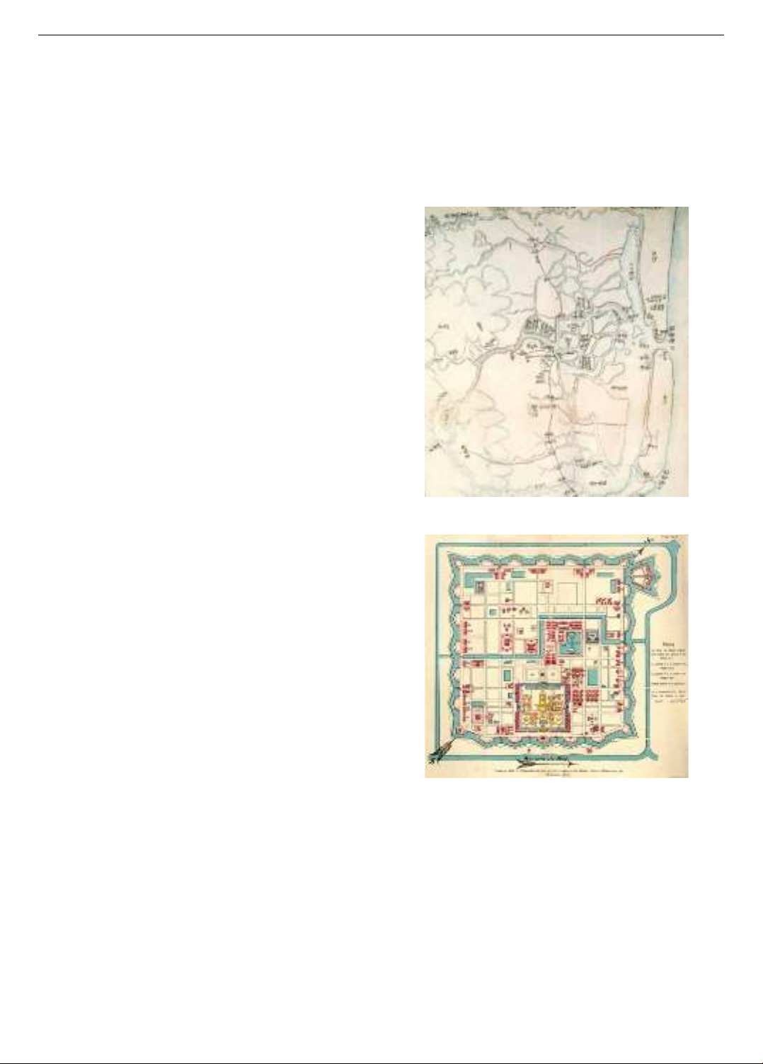
Figure 3. Map of the water system of Hue city in
Nguyen Dynasty (source: Dong Khanh dia du chi)
Figure 4. The water circulation system of Hue Citadel in
the colonial period [6]
The colonial domination period from 1884 to 1945:
traditional architecture in Hue underwent a transformation
that combined local styles with Western materials and
construction techniques. Under French protectorate rule, a
new urban landscape emerged alongside the traditional
areas in the northern part of Huong River, and characterized
by garden villas in the south. These villas were designed to
complement traditional architectural forms while adapting
to Hue's tropical climate, achieving a harmonious blend of
function and style. Huong River was the main part to
connect the north and the south of the city. The waterscape
of Huong basin created specific landscape of Hue city.
ISSN 1859-1531 - THE UNIVERSITY OF DANANG - JOURNAL OF SCIENCE AND TECHNOLOGY, VOL. 22, NO. 11C, 2024 125
3.2. The situation of surface water use in Hue Citadel
In recent decades, urbanization, population growth,
and land encroachment have significantly impacted the
areas surrounding the defensive moats, lakes, and Ngu Ha
River within Hue. Survey data indicates that residents
engage in a wide range of activities within these spaces,
including exercising, walking, resting, agricultural
practices, livestock raising, buying and selling goods,
festivals, and tourism. This diverse array of human
activities has become an integral part of daily life for the
community, as these areas serve not only as living spaces
but also as sources of income. However, these activities
have adversely affected the water system and local
heritage. Encroachments have led to the cultivation of
vegetables, littering, and even the construction of
structures that interfere with historical sites (Figure 5).
The discharge of domestic waste and various activities
have severely polluted the moats, leading to significant
environmental degradation and detracting from the visual
aesthetics of the urban landscape. These issues have
contributed to the overall pollution of the water system.
Additionally, ongoing construction and damming in the
area have caused the moat's water levels to decrease and
created blockages that disrupt the Citadel's water
management functions. This encroachment by residents
has further damaged the traditional landscape structure,
negatively impacting both the water system and the
integrity of the Citadel. The Figure 6 shows functional
layers’ analysis in Hue Citadel.
Figure 5. The situation of water surface use around Citadel and
defensive moat in 2016 (source: the author)
Figure 6. The spatial layers and water encroachment in
Hue Citadel (source: the author)
The project of relocating residents and clearing land in
area 1 of Thuong Thanh, Eo Bau in the Citadel and
defensive water’s moat phase 1 (2019-2021) contributes
to solving the problem of people's livelihood and
gradually restoring the image of Hue Citadel and the
water system. Promoting the value of heritage within the
contemporary context is a priority for both the
government and local communities. However, urban
expansion on Huong River to the south, with numerous
new development projects, has often overlooked ground
level considerations. This oversight has contributed to
recent flooding in the city, highlighting the need for a
balanced approach that integrates heritage conservation
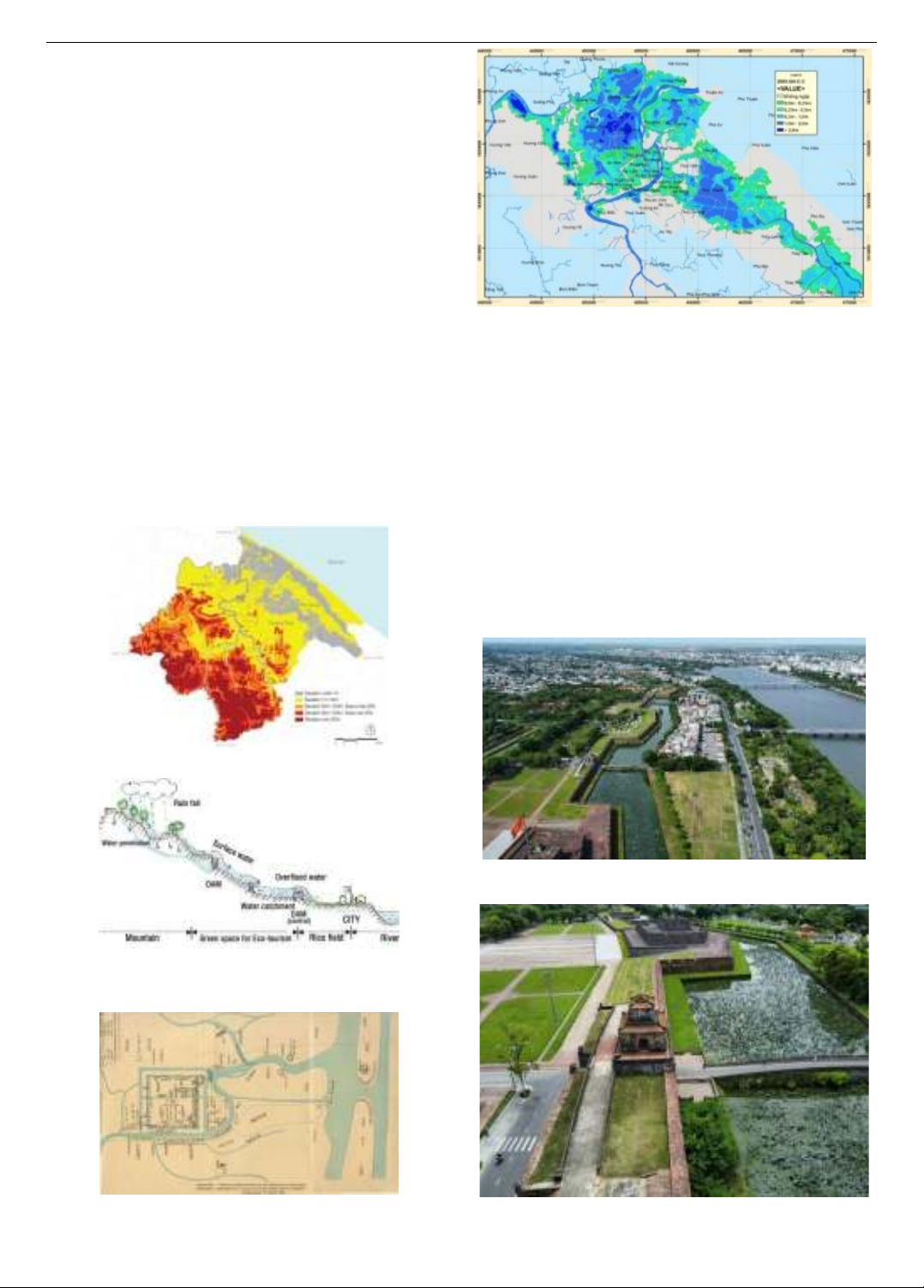
with sustainable urban planning (Figure 7). Additionally,
the activities of local residents and natural disasters
contribute to significant changes in the area. The Huong
River’s basin has a gentle slope and experiences
concentrated rainfall, resulting in a high frequency of
flooding events. Hue city is particularly vulnerable to
flooding. Data from the Kim Long station over a 27-year
period (1977-2003) indicates that there were 33 flood
events in which water levels exceeded 3.0 meters (with Le
Loi Street, along the river, at 3.2 meters). Of these, 10
events reached levels over 4.0 meters, and 5 events
surpassed 4.5 meters. These events are detailed in Table
1, which shows their monthly distribution.
Table 1. The data of flood events monthly in Huong River from
1977 to 2003 [7]
Over time, the water system and land use within the
Citadel have undergone significant changes due to
historical, natural, and human influences. These alterations
have impacted the original functions of the area, adversely
affecting the lives of residents and complicating the
preservation of cultural heritage in the region.
The big flood of Hue Citadel in
1999 (source: internet)
The flood of Hue city in 2022
(source: Tran Thien)
Figure 7. The flood in Hue city
3.3. Identification of the water elements of Hue city
Hue city in the overall structure of territory. It is
structured within a diverse geographical context that includes
various elements characteristic of a tropical climate. It
features a mountain range to the west, varied topography,
and plains rich with rivers, lakes, and diverse ecosystems. To
the east, there are marine systems, lagoons, and sand dunes
(figures 10 and 12). The city has been designed as an urban
center that closely integrates with its natural conditions,
aiming to create a model of sustainable development.
126 Vo Ngoc Duc
Ecological structure of Hue Citadel. The Citadel is
strategically positioned along the Huong River, providing
convenient water transportation and benefiting from the
protective surrounding mountains. The Citadel is
organized in layers, comprising the Imperial City, the
Forbidden City, and the outer Citadel. The Huong River
serves as the primary transportation route, while its
natural and artificial branches act as secondary pathways
that delineate the inner territories of the Citadel. These
river branches flow through the Citadel, interlinking with
over forty lakes and green spaces, thereby forming a rich
ecological landscape. This system not only supports self-
regulating water flow but also provides vital habitats for
local residents and wildlife, enhancing the overall
environmental quality of the area.
Historical records reveal that in early 1687, Phu Xuan
village was selected as the site for the capital of Annam.
The urban planning was guided by the principle of “using
the nearby Ngu Binh Mountain as a "Screen" and
involved constructing walls, building a palace, and
excavating a large lake in front” [8]. Feng Shui principles
were rigorously applied to determine the location,
orientation, and layout of the city. This methodology
included concepts such as the "front Screen", "back
Pillow", "left Azure Dragon", and "right White Tiger",
along with considerations for water surfaces and the
Ming-Tang element, all in alignment with the philosophy
of Universal Changes, which emphasized positioning in
the north and facing south (Figure 8 and 9).
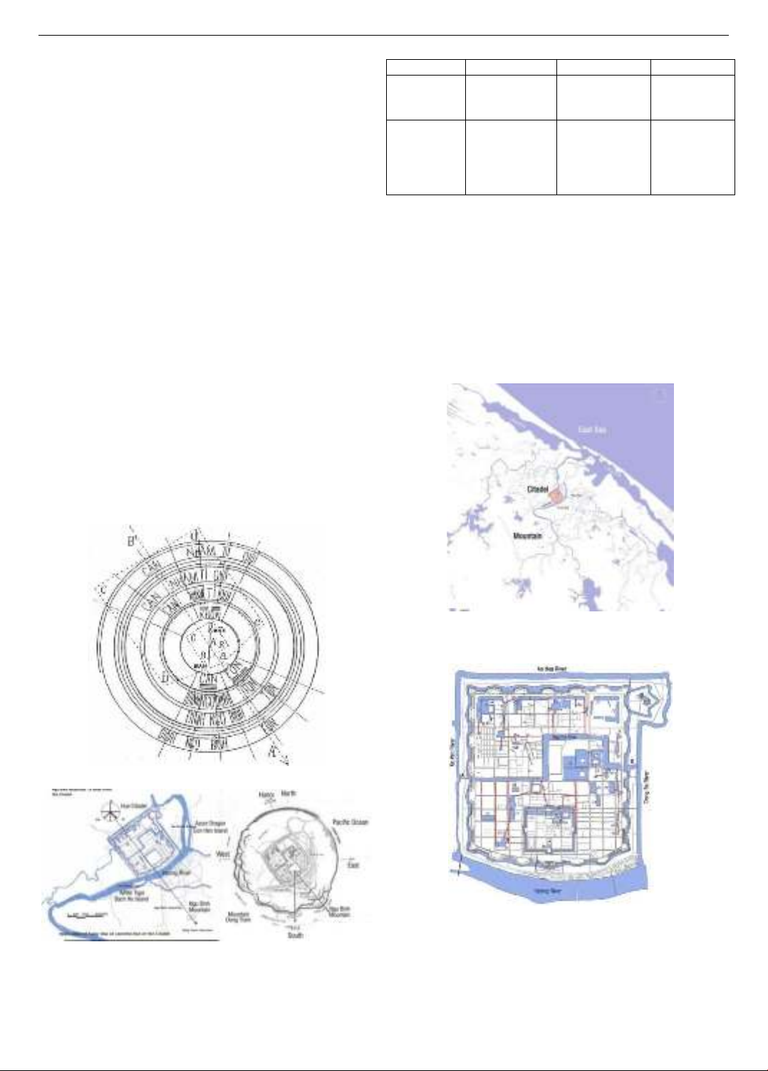
Figure 8. Compass for the direction choice [9]
Figure 9. The major axis and relationship with surrounding
natural elements in Hue Citadel [10]
Water system. The water system in Hue could be
divided two kinds, as follows:
Table 2. The kinds of water in the Hue city [1]
Category
Source
Signification
Type
Still water
from rain,
people
activity
Open space
Meaning full
Focus
Lake
Pond
Active
water
from
mountain
though the
city to lagoons
Orienting
Edging
Continuality
Waterfall
Stream
River
Lagoon
Sea
The water system of Hue Citadel functions as a
diverse ecosystem that is vital for environmental
protection, water regulation, and the overall waterscape of
the area. Key components of this system include the
defensive river, defensive moat, Ngu Ha River, and a
network of lakes (figures 10 and 11). The canals and
lakes, originally excavated to strengthen the citadel, were
historically interconnected with Huong River. Currently,
efforts are underway to restore these waterways, aiming
to reinstate their ecological functions and enhance the
Citadel's landscape.
Figure 10. The water system flows from mountains and
mountains through urban areas to lagoons and the sea
(source: the author)
Figure 11. Map of connection of the lakes in Hue Citadel
(source: the author)
3.4. The waterscape system in Hue Citadel and the lesson
for preservation and sustainable development planning
The ecological local technology of self-regulating
water flow. The lakes and river system in Hue Citadel
ISSN 1859-1531 - THE UNIVERSITY OF DANANG - JOURNAL OF SCIENCE AND TECHNOLOGY, VOL. 22, NO. 11C, 2024 127
were designed to facilitate self-regulating waterway,
serving as an ecological technology that enhances the
environment. The waterscape represents a unique
integration of human elements and nature, creating a
harmonious model that unites waterways with monuments
and landscapes, thereby shaping the local ecological
identity. This process has resulted in an urban
morphology that respects the region's architectural
heritage while offering a development model, adapting
with traditional features and the local climate. Ultimately,
this approach exemplifies a sustainable urban
development model that balances environmental, cultural,
and aesthetic considerations. The river system and lakes
were designed to maintain a self-regulating water flow.
This water management system is similar to a form of
local ecological technology aimed at protecting the water
environment. The waterscape of Hue city represents a
unique integration of nature and human. The waterway
design integrates seamlessly with local monuments and
landscapes, contributing to the identity of the ecological
system. This approach has led to an urban layout that
reflects local architectural characteristics while promoting
sustainable development that respects traditional elements
and the tropical climate of the region (Figure 12-15).
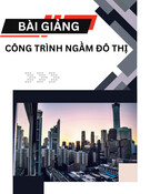
Figure 12. Topographic map of Hue city [11]
Figure 13. Topographic section from west to east illustrating
the water system's control for environmental self-regulation
(source: the author)
Figure 14. The connection of the lakes to river and lagoon of
Hue Citadel in Nguyen Dynasty [6]
Figure 15. The flood map of Hue (case study of
the regulation without water reservoir) [12]
Waterscape for city’s structure. Water has always
maintained its place as one of the most important design
elements in urban planning from the past to present.
Water has been used for different purposes for symbolic,
visual and auditory features. Each feature of water gives
life for a different application and space usage in
landscape design. The movement and silence factors
always give the effect of design related to water.
The waterscape, along with the visual form and
function of water, is applied in urban planning. It reflects
the movement, shape, and patterns of water and its
continuous transformation from source to sea. Water is
used to enhance the visual quality of the space in designs
[1] (Figure 16 and 17).
Figure 16. Waterscape of Hue Citadel and Huong River
(source: the author)
Figure 17. Waterscape of defensive moat
(source: the author)


![Bài giảng Quản lý vận hành và bảo trì công trình xây dựng [chuẩn nhất]](https://cdn.tailieu.vn/images/document/thumbnail/2025/20251006/agonars97/135x160/30881759736164.jpg)


![Ngân hàng câu hỏi trắc nghiệm Sức bền vật liệu 1: [Mô tả/Định tính Thêm để Tăng CTR]](https://cdn.tailieu.vn/images/document/thumbnail/2025/20250920/kimphuong1001/135x160/6851758357416.jpg)


![Trắc nghiệm Kinh tế xây dựng [chuẩn nhất]](https://cdn.tailieu.vn/images/document/thumbnail/2025/20250920/kimphuong1001/135x160/32781758338877.jpg)