
JOURNAL OF SCIENCE AND TECHNOLOGY DONG NAI TECHNOLOGY UNIVERSITY
366
Special Issue
CONTROL AND NAVIGATION OF MOBILE ROBOT IN ROS
SIMULATION PLATFORM
Son Huynh Thanh1*, Oanh Tran Thi Hoang2
1Dong Nai Technology University
2Binh Duong Economics and Technology University
*Corresponding author: Son Huynh Thanh, huynhthanhson@dntu.edu.vn
1. INTRODUCTION
Today, with the fast development of
robotic, it has attracted many attentions. As a
branch of robotics, mobile robot is a branch of
robotics and widely used in many cases, such as
industrial transportation, logistics, mobile
operations, logistic, etc. (Arkin, et al., 1990;
Köseoğlu, et al., 2017; Ochiai, et al.. 2014).
Mobile robots operate in many different
locations, different positions, so it is necessary
to have a precise position measurement device
for the robot (Siegwart, et al.. 2011). The
autonomous navigation of the robot to its target
location is simulated on Gazebo (Takaya, et al..
2016; Pietrzik, et al., 2019). To ensure
successfully navigation, SLAM localization
was employed to locate the TurtleBot3 in the
map (J. M. Santos, et al., 2019). The simulation
results were visualized using RViz and were
found to be satisfactory. This research not only
creates value for the industry, but also opens up
new opportunities for future creativity and
innovation.
2. METHODOLOGY
The Robot Operating System (ROS) is
introduce. In ROS, robot TurtleBot3 is used for
simulation. LiDAR is the tool described.
Additionally, the entire mapping, localization
and navigation process is simulated and
explained. TurtleBot3 can navigate different
obstacle environments and reached goal.
GENERAL INFORMATION
ABSTRACT
Received date: 06/03/2024
Control and navigation systems are two critical issues in
autonomous mobile robot control. In this paper, the Robot
Operating System (ROS) is studied. ROS is a free and open-
source platform, supported by large communities. It is not only
a platform for robot software development but also provides
programs with access to hardware resources. Localization and
mapping are performed on ROS using laser scanning data
from Light Detection and Ranging (LiDAR) with the
simultaneous localization and mapping (SLAM) method to
control and navigate the mobile robot. The simulation is
conducted in the Robot Visualization tool (RViz). The
mapping and path planning are demonstrated with various
obstacles, and the robot successfully reached its destination.
Revised date: 09/05/2024
Accepted date: 12/07/2024
KEYWORD
Autonomous mobile robot, controller;
LiDAR;
ROS;
RViz;
SLAM.

367
JOURNAL OF SCIENCE AND TECHNOLOGY DONG NAI TECHNOLOGY UNIVERSITY
Special Issue
2.1 TurtleBot3 Platform
TurtleBot3 is a compact, cost-effective
mobile robot, designed for education, research,
hobbies, and product development (Robotics,
2024). Its primary aim is significantly to reduce
the cost while maintaining its functionality and
quality, offering flexibility for expansion. The
TurtleBot3 can be customized in various ways
modifying the mechanical components and
optional parts like sensors and embedded
systems. Moreover. TurtleBot3 has been
developed to be the cost-effective and small-
sized mobile robot, making it is a suitable for
robust embedded system (Orkan Murat Çelik1,
Murat Köseoğlu, 2023).
2.2 Simultaneous Localization and Mapping
platform
Simultaneous Localization and Mapping is
a technique that enables a robot to create a map
of environment around robot and location itself
in the space. This technology permits establish
a mobile map. Allowing the efficient
digitization of large areas. SLAM systems
collect data, mapping space around
environments both indoor and outdoor (Takaya,
et al.,2016).
Mathematically, SLAM can be described by
following steps (Durrant-Whyte, et al., 2006):
XT is the position of robot. T is the sample
time.
𝑋𝑇 = {𝑥0, 𝑥1, 𝑥2, … 𝑥𝑇}
If UT is the robot’s movement between
times T-1 and T, assuming that this motion data
is derived from encoder readings or motor
control input, the robot’s time–dependent can
be written as:
𝑈𝑇 = {𝑢0, 𝑢1, 𝑢2, … 𝑢𝑇}
Accordingly, if it is assumed that the value
of 𝑚0, 𝑚1, 𝑚2… is presented objects around
the robot, M is written as:
𝑀𝑇 = {𝑚0, 𝑚1, 𝑚2, … 𝑚𝑛−1}
If each sensor on the robot captures only
one measure at a time, the complete set of
measurements ZT:
𝑍𝑇 = {𝑧0, 𝑧1, 𝑧2, … 𝑧𝑇}
The data obtained from position(XT),
odometer (UT) and observations (ZT) robot can
mapping the path. Two primary algorithms are
full SLAM and online SLAM that are used by
AMRs. AMR can navigate various areas
composed of successive point on the map to
reach a target. The probability of the next joint
to be followed by AMR along the full SLAM
XT, depends on various factors, and this
relationship is represented by the following
equation:
𝑝{𝑋𝑇, 𝑀 ∨ 𝑍𝑇, 𝑈𝑇}
A difference between the full SLAM and
online SLAM: In online SLAM, XT indicate
the next most probability path along M for the
next point. As seen, full SLAM aims to estimate
the entire path (XT) of the robot, while online
focus solely on the current trajectory.
2.3 Robotic Operating System (ROS)
The Robot Operating System (ROS) is an
open-source framework based on Linux,
designed for controlling robots (ROS Wiki,
2024). It facilitates peer-to-peer
communication, where executable programs
known as nodes interact with each other during
runtime. These nodes are registered with the
ROS master, which is essential for them to be
aware of one another. Instead of direct
communication between nodes, they exchange
information by publishing or subscribing to
messages on specific topics. For instance, if a
node requires data, it subscribes to the relevant
topic, while nodes generating data publish their
messages to that topic. This setup exemplifies a
decoupled system, allowing different parts of
JOURNAL OF SCIENCE AND TECHNOLOGY DONG NAI TECHNOLOGY UNIVERSITY
368
Special Issue
the robot to perform distinct functions
independently, ensuring that a failure in one
function does not disrupt the entire robot’s
operation. Another benefit of ROS is the
reusability of code, which allows researchers to
build upon existing codebases rather than
starting from scratch, thereby accelerating the
development process.
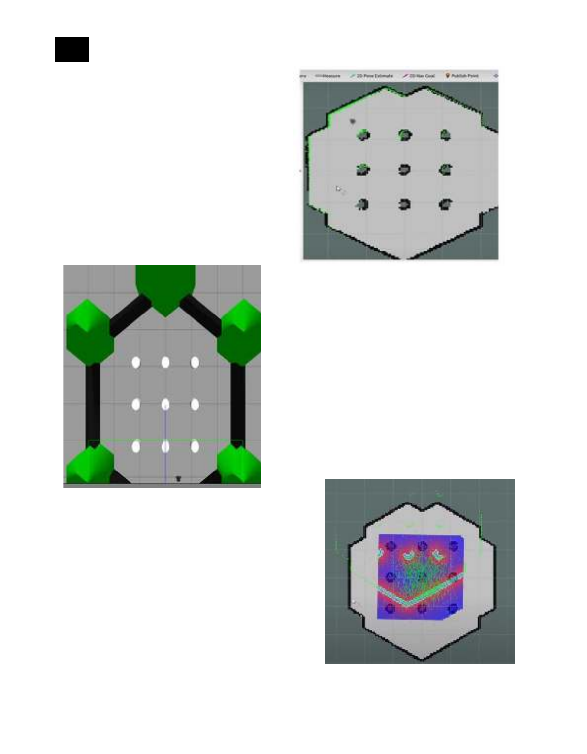
2.4. Simulation world
Gazebo is the platform to simulate and the
leader of in robot simulation. At figure 1, there
is a Hexagon wall. There are 9 obstacles inside.
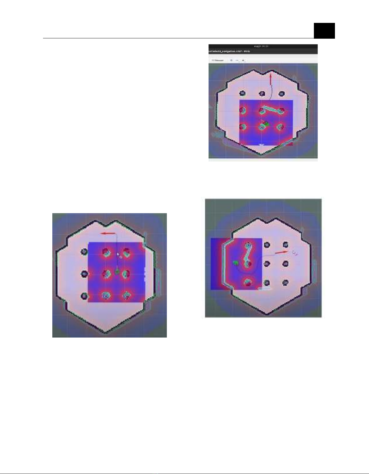
2.5 Simultaneous Mapping and Localization
For an autonomous robot to successfully
navigate within an unfamiliar environment, it
must be able to both map its surroundings and
determine its own location within that
environment. This is why Simultaneous
Localization and Mapping (SLAM) plays a
crucial role.
Figure 2. Robot maps the enviroment
3. FINDINGS AND DISCUSSION
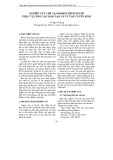
3.1. Mapping-localizing
To visualize the simulation results, I
utilized RViz, a 3D visualization tool
compatible with ROS. RViz allows for the
visualization of various elements such as 3D
robot models, sensor data, and camera inputs.
Figure 3 displays the projection map as
rendered in RViz. This figure illustrates the
displacement between the local and global
maps, highlighting the necessity of localization.
Figure1. Robot simulation environment
Figure 3. Global map and local map is not match
369
JOURNAL OF SCIENCE AND TECHNOLOGY DONG NAI TECHNOLOGY UNIVERSITY
Special Issue
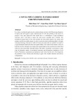
The TurtleBot3's movement is managed by
the move-base package, which includes a ROS
node named move-base. This package
maintains both local and global cost maps to
facilitate local and global planning. Figures 4
and 5 depict these cost maps. The cost maps
record obstacle information, with the global
cost map used for overall environment planning
and the local cost map utilized for short-range
planning and obstacle avoidance. The planner
assists the TurtleBot3 in navigating according
to its global plan and setting preferences for
movement.
3.2 Navigation without obstacle
Simulation showing that the robot is chosen
the line to the goal. And the destination is
satisfied.
3.3 Navigation with obstacle
From figure 4 and figure 5, we can easily see
that the goal is the same but from the figure 5,
we see the different path planning.
Figure 6. Robot is running to the goal with
vertical obstacle
Figure 5 and figure 6 is simulated with
different angles to check the path planning. In
environments with multiple obstacles, the
robot's ability to navigate effectively depends
on the accuracy of the sensors and the
responsiveness of the planning algorithms. The
quality of the local cost map is critical, as it
needs to quickly and accurately reflect changes
in the environment for the robot to make the
best decisions.
Figure 4. Robot is running to the goal
without obstacle
Figure 5: Robot is running to the goal
in horizontal obstacle

JOURNAL OF SCIENCE AND TECHNOLOGY DONG NAI TECHNOLOGY UNIVERSITY
370
Special Issue
4. CONCLUSION
The objective of our work was to simulate a low-
cost autonomous mobile robot in simulation
environment. The mobile robot can capable
map an unknown environment using an
inexpensive LiDAR. Additionally, the robot
model successfully localized itself within the
map generated by the SLAM platform and
navigated to the designated point. The entire
navigation process was visualized using
RViz. The robot effectively reached its point
with different simulation environments.
Effective navigation in the presence of obstacles
is a critical aspect of autonomous robotics,
requiring the integration of robust planning
algorithms, real-time sensor data, and
adaptive strategies. By continuously
updating its cost maps and adjusting its path
in response to obstacles.
REFERENCES
Arkin, R. C., & Murphy, R. R. (1990).
Autonomous navigation in a manufacturing
environment. IEEE Transactions on
Robotics and Automation, 6(4), 445-454.
https://doi.org/10.1109/70.59355.
Durrant-Whyte, H., & Bailey, T. (2006).
Simultaneous localization and mapping: part
I. IEEE Robotics Automation Magazine,
13(2), 99–110.
https://doi.org/10.1109/MRA.2006.1638022.
J. M. Santos, D. Portugal and R. P. Rocha.
(2019). An evaluation of 2D SLAM
techniques available in Robot Operating
System. IEEE International Symposium on
Safety, Security, and Rescue Robotics
(SSRR), Linkoping, 2013, pp. 1-6.ing.
Köseoğlu, M., Çelik, O. M., & Pektaş, Ö. (2017).
Design of an autonomous mobile robot based
on ROS. 2017 International Artificial
Intelligence and Data Processing Symposium
(IDAP),1-5.
https://doi.org/10.1109/IDAP.2017.8090199.
Ochiai, Y., Takemura, K., Ikeda, A., Takamatsu,
J., & Ogasawara, T. (2014). Remote control
system for multiple mobile robots using touch
panel interface and autonomous mobility.
International International Conference on
Intelligent Robots and Systems, 3272–3277.
https://doi.org/10.1109/IROS.2014.6943017.
Orkan Murat Çelik1, Murat Köseoğlu (2023). A
Modified Dijkstra Algorithm for ROS Based
for autonomous Mobile Robots. Journal of
Advanced Research in Natural and Applied
Sciences, 3272-3277.
https:// doi.org/10.28979/jarnas.1119957
Pietrzik, S., and B. Chandrasekaran (2019).
"Setting up and Using ROS Kinetic and
Gazebo for Educational Robotic Projects and
Learning." In Journal of Physics:
Conference Series, vol. 1207, no. 1, p.
012019. IOP Publish.
Robotics. (2024). TurtleBot3 simulation.
Retrieved July 28, 2024, from
https://emanual.robotis.com/docs/en/platfor
m/turtlebot3/simulation/
ROS Wiki. (2024). Documentation.
http://wiki.ros.org/Documentation.
Siegwart, R., Nourbakhsh, I. R., & Scaramuzza,
D. (2011). Introduction to Autonomous
Mobile Robots. (Second Edi, Vol. 5). The
MIT Press.
Takaya, Kenta, Toshinori Asai, Valeri
Kroumov, and Florentin Smarandache
(2016). "Simulation environment for mobile
robots testing using ROS and Gazebo." 20th
International Conference on System Theory,
Control and Computing (ICSTCC), pp. 96-
101. IEEE, 2016. 3272–3277


![Thiết kế sơ bộ robot chuyển động trong đường ống thủy lợi [chuẩn nhất]](https://cdn.tailieu.vn/images/document/thumbnail/2025/20250411/vimaito/135x160/2931744365389.jpg)


![Bài giảng Vi điều khiển Nguyễn Huy Hoàng: Tổng hợp kiến thức [Chuẩn nhất]](https://cdn.tailieu.vn/images/document/thumbnail/2026/20260316/hoatrami2026/135x160/72211773806757.jpg)


![Bài giảng Tự động hoá thiết bị điện [chuẩn nhất]](https://cdn.tailieu.vn/images/document/thumbnail/2026/20260312/hoabattu2026/135x160/61691773631881.jpg)
