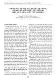
Journal of Mining and Earth Sciences Vol. 66, Issue 1 (2025) 31 - 42 31
Identification of inundated area by debris flow using
LAHARZ model - A case study in the Trong La
catchment in Ho Bon, Mu Cang Chai, Yen Bai
Hieu Trung Tran 1,*, Tien Van Pham 1, Quan Cong Nguyen 1, Cuong Quoc Tran 2, Hai
Thanh Pham 1, Dung Van Chu 3, Thanh Trung Nguyen 1, Anh Duc Nguyen 1, Thao
Phuong Bui 1
1 Institute of Geological Science - Vietnam Academy of Science and Technology, Hanoi, Vietnam
2 Ministry of Science and Technology, Hanoi, Vietnam
3 The Vietnam Geological Department, Hanoi, Vietnam
ARTICLE INFO
ABSTRACT
Article history:
Received 12th Sept. 2024
Revised 29th Dec. 2024
Accepted 08th Jan. 2025
Debris flow is one of the most common geological disasters in Vietnam,
occurring in mountainous areas and causing catastrophic impacts on
both the economy and human lives. This article shows the results of a
debris flow simulation that took place on August 5, 2023, in Trong La
village, Ho Bon commune, Mu Cang Chai district, Yen Bai province,
through an empirical model called LAHARZ and digital elevation model
(DEM). The debris flow also was assessed for damage to the built-up area.
The LAHARZ model is based on empirical equations that were derived
from historical debris flood statistics. The equations include A = 0.05
V^(2⁄3) and B = 200 V^(2⁄3), in which A is the cross-sectional area, B is the
planimetric area, and V is the volume. This study uses drone images and
digital elevation model with 0.5m spatial resolution, which were created
on August 12, 2023, by using the Phantom 3 Professional drone. The
debris flow's source area is roughly 78104 m2, corresponding to a volume
of 8,000÷10,000 m3. For this reason, the LAHARZ model is simulated with
volumes of 5,000; 8,000; 10,000; 15,000 and 20,000 m3. LAHARZ
simulation results were validated by comparing them to field survey
evidence. The result shows that the model results are quite similar to the
actual inundated area with TPR and TS values being 0.717 and 65.9%,
respectively. This study also demonstrates that the false irregular edges in
the delineated inundation zones supposedly originated because of a lack
of DEM accuracy. The LAHARZ model simulation has many advantages in
terms of time and the few parameters used, which enable rapid evaluation
of debris flow scenarios.
Copyright © 2025 Hanoi University of Mining and Geology. All rights reserved.
Keywords:
Debris flow,
Ho Bon,
LAHARZ,
Mu Cang Chai.
_____________________
*Corresponding author
E - mail: trunghieu95ctb@gmail.com
DOI: 10.46326/JMES.2025.66(1).04

32 Tạp chí Khoa học Kỹ thuật Mỏ - Địa chất Tập 66, Kỳ 1 (2025) 31 - 42
Đánh giá phạm vi ảnh hưởng dòng lũ bùn đá bằng mô hình
LAHARZ - Trường hợp nghiên cứu tại lưu vực đầu nguồn bản
Trống Là, xã Hồ Bốn, Mù Cang Chải, Yên Bái
Trần Trung Hiếu 1,*, Phạm Văn Tiền 1, Nguyễn Công Quân 1, Trần Quốc Cường 2,
Phạm Thanh Hải 1, Chu Văn Dũng 3, Nguyễn Trung Thành 1, Nguyễn Đức Anh 1, Bùi
Phương Thảo 1
1 Viện Địa chất- Viện Hàn lâm Khoa học và Công nghệ Việt Nam, Hà Nội, Việt Nam
2 Bộ Khoa học và Công Nghệ, Hà Nội, Việt Nam
3 Cục Địa chất, Hà Nội, Việt Nam
THÔNG TIN BÀI BÁO
TÓM TẮT
Quá trình:
Nhận bài 12/9/2024
Sửa xong 29/12/2024
Chấp nhận đăng 08/01/2025
Lũ bùn đá là một trong những tai biến địa chất phổ biến ở Việt Nam, xuất
hiện ở các khu vực đồi núi gây ra nhiều thiệt hại về kinh tế và sinh mạng con
người. Bài báo này trình bày kết quả mô phỏng một dòng lũ bùn đá tại xã Hồ
Bốn, huyện Mù Cang Chải, tỉnh Yên Bái xảy ra ngày 5/8/2023 sử dụng mô
hình thực nghiệm LAHARZ trên mô hình số địa hình, đồng thời sử dụng kết
quả này đánh giá thiệt hại với công trình xây dựng. Mô hình LAHARZ được
xây dựng dựa trên các phương trình thực nghiệm được tính toán từ các
thống kê các sự kiện lũ bùn đá trong quá khứ. Các phương trình sử dụng bao
gồm: A=0,05 V^(2⁄3); B=200 V^(2⁄3). Trong đó A là diện tích mặt cắt, B là
diện tích trên mặt phẳng, V là thể tích. Nghiên cứu sử dụng ảnh drone và mô
hình số địa hình với độ phân giải không gian 0,5 m được xây dựng tại thời
điểm 12/8/2023 bằng drone Phantom 3 Professional. Với diện tích vùng
nguồn xác định trong khoảng 78.104 m2 tương ứng thể tích dòng
8.000÷10.000 m3, mô hình LAHARZ được mô phỏng theo các thể tích 5.000;
8.000; 10.000; 15.000; 20.000 m3. Đối sánh với các vị trí khảo sát thực địa
cho thấy kết quả mô hình khá tương đồng với vùng ảnh hưởng thực tế. Việc
đánh giá mô hình được tính thông qua phần diện tích chồng lấn cho giá trị
TPR và TS lần lượt là 0,717 và 65,9%. Bài viết cũng chỉ ra hiện tượng các
cạnh không đều của kết quả bị ảnh hưởng nhiều bởi độ chính xác của DEM.
Việc mô phỏng mô hình LAHARZ có nhiều ưu điểm về thời gian, ít các thông
số sử dụng và có ý nghĩa thực tiễn trong việc đánh giá nhanh các kịch bản lũ
bùn đá có thể xảy ra.
© 2025 Trường Đại học Mỏ - Địa chất. Tất cả các quyền được bảo đảm.
Từ khóa:
Hồ Bốn,
LAHARZ,
Lũ bùn đá,
Mù Cang Chải.
_____________________
*Tác giả liên hệ
E - mail: trunghieu95ctb@gmail.com
DOI: 10.46326/JMES.2025.66(1).04

Trần Trung Hiếu và nnk./Tạp chí Khoa học Kỹ thuật Mỏ - Địa chất 66 (1), 31 - 42 33
1. Mở đầu
Lũ bùn đá thường thường chứa khoảng từ 10-
15% đến 40-60% hàm lượng các vật liệu rắn
(tảng, dăm, cuội, sạn, cát, bùn, sét). Lũ bùn đá
thường xuất hiện đột ngột với cường độ cao và tốc
độ lớn trên các sông, suối nhỏ ở vùng núi. Đặc
điểm của lũ bùn đá là thời gian xuất hiện rất ngắn
với hàm lượng chất rắn cao và có sức tàn phá lớn.
Nó có thể được hình thành do mưa lớn, hoặc khi
không có mưa do vỡ hồ, đập tự nhiên do hiện
tượng trượt lở chặn dòng sông, suối.
Lũ bùn đá là mối hiểm hoạ đối với cơ sở hạ
tầng, tính mạng con người và là thách thức lớn đối
với sự phát triển kinh tế xã hội ở nhiều nước trên
thế giới. Tại Việt Nam, lũ bùn đá là một trong
những thiên tai tàn khốc, hay xảy ra đặc biệt ở các
khu vực miền núi phía bắc. Một số trận lũ bùn đá
lớn đã xảy ra gồm Mường Lay (8/1996); Nam
Coong, Sìn Hồ, Lai Châu (10/2000); Tân Nam, Xín
Mần, Hà Giang (7/2002); Du Tiến, Yên Minh, Hà
Giang (7/2004); Khen Lên, Pắc Nam, Bắc Kạn
(7/2009); Nam Lục, Bắc Hà, Lào Cai (9/2012);
Bản Khoang, Sa Pa, Lào Cai (9/2013); Mù Cang
Chải, Yên Bái (3/8/2017); Nặm Păm, Mường La,
Sơn La (3/8/2017); Tà Cạ, Kỳ Sơn, Nghệ An
(10/2022); Hồ Bốn, Mù Cang Chải, Yên Bái
(5/8/2023),…
Với sự xuất hiện thường xuyên của các đợt
mưa lớn do biến đổi khí hậu, tần suất, quy mô và
mức độ phức tạp của dòng lũ bùn đá có thể tiếp
tục gia tăng trong tương lai. Do đó, việc xác định
chính xác vị trí, đường đi và phạm vi ảnh hưởng
tại các khu vực có nguy cơ lũ bùn đá có thể giúp
giám sát dòng bùn đá hiệu quả và thực hiện các
chính sách kinh tế xã hội kịp thời. Đã có nhiều tiến
bộ đáng kể về quá trình phát triển các mô hình mô
phỏng các đặc tính của các vụ lũ bùn đá. Trong đó
nổi bật với các kiểu mô hình chính là mô hình
thống kê thực nghiệm, mô hình động. Các mô hình
này đã được hiệu chỉnh lại trong nhiều nghiên cứu
(Bảng 1) và trong một số trường hợp chúng được
sử dụng làm công cụ dự báo tai biến lũ bùn đá
trong khu vực.
Bảng 1. Một số phần mềm mô phỏng lũ bùn đá hiện nay.
Phần
mềm
Phương pháp
Ưu điểm
Nhược điểm
Nguồn
LAHARZ,
DFLOWZ
Thống kê
thực nghiệm
- Giao diện dễ sử dụng
- Dự đoán nhanh vùng ảnh hưởng
Khu vực bị ảnh hưởng phụ thuộc
vào mức độ tin cậy của thể tích dòng
bùn đá. Do đó thể tích có thể được
đánh giá quá cao hoặc quá thấp
Berti &
Simoni,
2014;
Schilling,
1998.
FLO-2D
Sai phân hữu
hạn (Finite
Difference
Method -
FDM)
- Có khả năng tích hợp nhiều loại
dữ liệu không gian trong một mô
hình đơn lẻ (shape file, ảnh UAV,
DEM,…).
- Phần mềm có thể được kết hợp
với SWMM, MODFLOW.
- Không cần dữ liệu sự phân bố
khối trượt ban đầu.
- Các phần tử lưới đại diện cho một
giá trị độ cao duy nhất, hệ số nhám
manning và độ sâu dòng chảy.
- Dòng 1D (không có dòng thứ cấp,
hoặc sự phân bố vận tốc thẳng
đứng).
- Phần mềm có thể tính toán quá
vùng ảnh hưởng thực tế.
Cesca &
D’Agostino,
2008
Debris-
2D
FDM
- Không yêu cầu giá trị hệ số nhám
manning (n) và hệ số nhớt
- Thời gian kết thúc, độ sâu dòng
chảy tối đa và vùng bị ảnh hưởng
khớp với quan sát hiện trường.
- Dữ liệu đầu vào cần có sự phân bố
khối trượt ban đầu.
- Có giao diện phần mềm nhưng
chưa hoàn thiện.
Liu &
Wu, 2018
RAMMS
Thể tích hữu
hạn (Finite
Volume
Method-
FVM)
- Được sử dụng để mô phỏng áp
suất, chiều cao dòng tối đa, sự xói
mòn ở các phần khác nhau của
dòng bùn đá.
- Phân tích gần thời gian thực
- Cần hiệu chỉnh thông số ma sát và
hỗn hợp.
- Do không sử dụng ứng suất cắt nên
dòng chảy có cùng vận tốc trung
bình ở mọi điểm.
Bartelt &
nnk,
2017

34 Trần Trung Hiếu và nnk./Tạp chí Khoa học Kỹ thuật Mỏ - Địa chất 66 (1), 31 - 42
Các phương pháp mô hình động phát triển sử
dụng các mô hình vật lý, các định luật bảo toàn khối
lượng, động lượng và năng lượng cũng như cơ chế
dòng bùn đá. Một số mô hình thường được sử dụng
để mô tả đặc tính của dòng bùn đá là mô hình lực
cản ma sát Coulomb; mô hình Bingham; Coulomb-
Viscous và mô hình khả năng chống ma sát-hỗn
loạn Voellmy. Cách tiếp cận này cho phép xác định
đặc điểm hình học duy nhất và đặc điểm vật liệu địa
phương được tính đến một cách rõ ràng và nó cung
cấp các ước tính về vận tốc và độ sâu dòng chảy tại
các điểm khác nhau trên đường đi. Các mô hình này
thường được phát triển từ các mô hình thủy động
lực học trung bình theo độ sâu (dòng chảy nông),
mô phỏng chuyển động lũ bùn đá trên mô hình số
địa hình với nhiều các tham số cơ lý đất (Bảng 1).
Các mô hình điển hình dạng này như FLO-2D,
Debris-2D, RAMMS, Massmov2D,… Các mô hình
vật lý yêu cầu khá nhiều các tham số đầu vào như
DEM, hệ số nhám manning-n , hệ số nhớt, giới hạn
chảy (Pa), nồng độ thể tích (Cv), sự phân bố vật liệu
ban đầu,…
Các phương pháp thống kê thực nghiệm không
quan tâm nhiều đến các quá trình vật lý cũng như
độ phức tạp của các dòng lũ bùn đá. Chúng mô tả
dòng bùn đá như mô hình vật lý 1 pha dựa trên các
chỉ số thống kê từ các trận bùn đá trong quá khứ.
Một số phương trình mô tả mối quan hệ khoảng
cách dịch chuyển khối trượt, lũ bùn đá và thể tích
(Li, 1983; Nicoletti & Sorriso, 1991; Fell và nnk.,
2007) có dạng log(H/L)=-a log V+b. Trong đó a là
hệ số góc của đường thẳng, b là giao điểm của
đường thẳng tại logV = 0, H và L là chiều cao và
khoảng cách khối, và V là thể tích khối. Các giá trị
của hệ số a và b khác nhau với từng cách tiếp cận
và khu vực khác nhau. Li (1983) đã thu thập một
tập mẫu gồm 76 vụ trượt lở đất để tìm ra tương
quan giữa thể tích và H/L, cũng như giữa thể tích
trượt lở và diện tích lan rộng. Bỏ qua tất cả các sự
kiện với thể tích nhỏ hơn 105 m3, thu được công
thức log(H/L)= -0,1529 logV+0,664.
Ngoài ra một số phương trình thực nghiệm
khác mô tả mối tương quan thống kê giữa thể tích,
diện tích ảnh hưởng và diện tích tiết diện dòng
cũng đã được đề xuất (Iverson & nnk, 1998) với các
phương trình hồi quy thường có dạng A=cV^(2⁄3)
và B=d.V^(2⁄3). Điển hình là các mô hình như
LAHARZ (Schilling, 1998), DFLOWZ (Berti &
Simoni, 2014),… Tỷ lệ 2/3 cố định và đã được
chứng minh bởi Iverson & nnk (1998) bằng sự
tương đồng hình học. Tuy nhiên hệ số c, d có sự
khác biệt trong các nghiên cứu như c=0,05, d=200
(Schilling, 1998); c= 0,07, d=18 (Simoni & nnk,
2011),… Những khác biệt này được giải thích bởi
sự phân tán của dữ liệu do sự không chắc chắn của
các phép đo. Do trong thực tế, tính di động của dòng
bùn đá chắc chắn bị ảnh hưởng bởi hàm lượng
nước, phân phối kích thước hạt, hoặc sự có sẵn vật
liệu. Tuy nhiên không tìm thấy sự khác biệt có hệ
thống giữa các bộ dữ liệu thu thập trong các môi
trường địa chất khác nhau (Simoni & nnk, 2011).
Các mô hình động cho kết quả đáng tin cậy nhất, là
một trong những cách tiếp cận hiệu quả hiện nay
trong nghiên cứu tai biến địa chất như trượt lở và
lũ bùn đá. Tuy nhiên chúng yêu cầu về nhiều tham
số đầu vào như hệ số nhớt, giới hạn chảy (Pa), nồng
độ thể tích (Cv), sự phân bố vật liệu ban đầu,… hoặc
các thử nghiệm trong phòng thí nghiệm ở tỉ lệ nhỏ
hoặc tỉ lệ thực ngoài hiện trường rất phức tạp và
tốn kém chi phí.
Nghiên cứu này xác định diện tích ảnh hưởng
dòng lũ bùn đá sử dụng mô hình thực nghiệm
LAHARZ tại lưu vực đầu nguồn bản Trống Là, xã Hồ
Bốn huyện Mù Cang Chải , tỉnh Yên Bái. Khu vực
này xảy ra trận lũ bùn đá lớn ngày 5/8/2023, gây
thiệt hại về người và tài sản với nhiều công trình
nhà cửa ruộng vườn bị vùi lấp và cuốn trôi. Nghiên
cứu mang lại nhiều ý nghĩa thực tiễn trong việc áp
dụng mô hình LAHARZ trong quản lý rủi ro lũ bùn
đá tại Việt Nam.
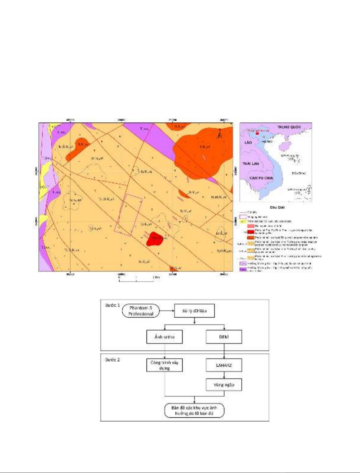
2. Khu vực nghiên cứu
Khu vực nghiên cứu thuộc bản Trống Là, xã Hồ
Bốn, Mù Cang Chải, Yên Bái nằm ở rìa bồn trũng Tú
Lệ -được coi là rift nội lục, là bồn độc lập dạng hình
máng, hình thành trong Mesozoi (Trần & Nguyễn,
1988). Các thành tạo nổi bật trong khu vực nghiên
cứu thuộc phức hệ núi lửa Nậm Kim, phức hệ Ngòi
Thia, phức hệ Phu Sa Phìn (Hình 1) bao gồm trachyt
porphyr, ryolit porphyr,…. Các đá núi lửa phức hệ
Nậm Kim bị biến đổi khá mạnh như albit hóa,
berezit hóa, thành phần nhiều khoáng vật sét tạo
điều kiện thuận lợi cho các tai biến trượt lở, lũ bùn
đá xảy ra. Vùng nghiên cứu có địa hình núi cao với
độ cao dao động từ 400÷2042 m. Địa hình khu vực
Hồ Bốn có độ chia cắt sâu lớn, độ dốc sườn trung
bình lớn (> 450). Do đó các suối nhánh thường
ngắn, dốc, lòng suối hẹp, phân bố dọc theo các đứt
gãy lớn trong khu vực. Do ảnh hưởng của mưa lớn,
hiện tượng trượt lở hàng loạt xuất hiện tại hàng
Trần Trung Hiếu và nnk./Tạp chí Khoa học Kỹ thuật Mỏ - Địa chất 66 (1), 31 - 42 35
trăm vị trí trên một khu vực rộng tại xã Hồ Bốn vào
ngày 5/8/2023. Dạng trượt lở chính gồm trượt
chảy và trượt tịnh tiến trên vỏ phong hóa mỏng.
Thảm thực vật khá thưa thớt chủ yếu là rừng thưa
tái sinh, … Lươ ng mưa trước và sau thời điểm xảy
ra lũ bùn đá tại khu vực khá lớn từ 41,8 mm
(03/8/2023) đến 163,4 mm (ngày 06/8/2023).
Trượt lở hàng loạt trên diện rộng xuất hiện đã phát
sinh nhiều dòng lũ bùn đá và lũ quét tàn phá nhiều
khu vực dân cư và sản xuất của xã. Đáng chú ý là
dòng lũ bùn đá xuất hiện dọc khe suối phía sau Ủy
ban Nhân dân xã Hồ Bốn thuộc lưu vực đầu nguồn
bản Trống Là gây thiệt hại nặng nề tại khu vực
trung tâm xã. Khe suối này bắt đầu từ bản Trống
Gầu Bua và đổ ra sông Nậm Kim phía trước Ủy ban
Nhân dân xã.
3. Dữ liệu sử dụng và phương pháp nghiên cứu
Quy trình nghiên cứu (Hình 2) gồm 2 bước
chính: (1) Thu nhận ảnh drone và xử lý số liệu xây
Hình 1. Bản đồ địa chất khu vực nghiên cứu tỷ lệ 1: 50.000 (Đinh, 2004).
Hình 2. Sơ đồ quy trình nghiên cứu.